Ijraset Journal For Research in Applied Science and Engineering Technology
- Home / Ijraset
- On This Page
- Abstract
- Introduction
- Conclusion
- References
- Copyright
ALERT MATE: Accident Detection and Smart Rescue System
Authors: Prathmesh Tangade, Digambar Bhangale, Aryan Varma, Yogita Dose, Dr. Vinod Wadne
DOI Link: https://doi.org/10.22214/ijraset.2024.65875
Certificate: View Certificate
Abstract
This project proposed \"Android-based accident detection and smart rescue with real-time location tracking\" to reduce the response time and increase the chance of survival in a car accident. The system uses the smartphone\'s accelerometer and gyroscope sensors to detect rapid, unusual movements that may indicate an accident. When detected, it immediately sends an alert to the emergency contact with the location of the incident and provides instant location to assist the rescue team. The front-end of the system is built using Flutter to provide a user-friendly interface, while the back-end is built using Spring Boot to manage files, user accounts, and reports. Firebase Cloud Messaging (FCM) integration is used for push notifications to ensure timely communication. With powerful data analytics, continuous location tracking, and timely notifications, the system demonstrates the ability of mobile devices to shorten emergency response times and save lives. The report outlines the design process, methodology, testing, and recommendations for future improvements, such as machine learning, to improve the accuracy of the nature sensing layer.
Introduction
I. INTRODUCTION
Road crashes are a major cause of injury and death worldwide, so it is important to develop solutions that shorten the time between crashes and the arrival of emergency services. Often, a delay in notifying emergency personnel can have a significant impact on the injured. This creates the need for reliable automated crash and intelligent rescue systems.
In this context, we propose a system that uses the capabilities of Android smartphones to search for real-time situations and find locations. The system uses sensors such as accelerometers and gyroscopes, which are found in most modern smartphones. These sensors allow the device to quickly detect changes that may indicate an emergency. When such an event is detected, the system automatically triggers an alert and shows the exact location of the incident using GPS data.
When an accident is detected, the system automatically triggers an emergency alert and uses Global Positioning System (GPS) data to find the exact location of the object. GPS coordinates are sent to the emergency contact list or directly to emergency services. This allows the service to be delivered to the actual location without affecting the user, which is important in cases where the user is incapacitated.
To ease the development of the integration and ensure compatibility across various Android devices, the system is implemented using Flutter, an open-source user interface toolkit created by Google. Flutter’s strong support for mobile development allows integration with hardware devices, including sensor APIs and service providers, making it a perfect choice for this application. The system architecture is designed to be lightweight, allowing it to run efficiently in the background without affecting the battery life or performance of the smartphone.
This next article discusses the design and use of intelligent accident detection and rescue, as well as the integration of sensor operating data, the process of eliminating blame for the accident, and the track. After rigorous testing, it was shown that the system can identify the situation and report precise details of the location to the rescue services, thus enabling the designed road safety improvement.
II. LITERATURE SURVEY
Many studies have investigated the potential for widespread use of smartphones and their onboard sensors in detecting car crashes and for instantaneous data processing. Manufacturers have integrated accelerometers, gyroscopes, and GPS components into smartphones to create systems that can recognize collisions and quickly warn of accidents.
Early research [1] suggests that smartphones can capture incidents by monitoring sensors such as accelerometers and GPS. These machines typically look for speed patterns to indicate a collision. However, some systems require users to interact with a web server or interface to report the incident, which can introduce delays.
One of the limitations of these diagnostic tools is that they can cause false alarms, as a phone drop or sudden movement can be interpreted as an accident that will cause unnecessary alarm. Using advanced algorithms or filters will help reduce errors.
Further research [2] has investigated the use of multiple sensors, such as accelerometers, impact sensors, and pressure sensors, to provide more accurate crash detection. These systems can detect the location and severity of the incident and notify emergency responders. However, the disadvantage is that using multiple sensors increases battery life and makes continuous monitoring impossible.
Time-based location finding, as seen in apps like Track, has gained attention for its ability to increase the chance of survival by allowing emergency services to respond quickly to the situation [3]. These features can also help emergency responders allocate resources efficiently in emergency situations. However, one limitation of the Track app is that it relies on a reliable network connection to deliver notifications and location information. In rural or remote areas with limited connectivity, the system may not work properly, which can delay emergencies.
Study by Smith et al. [7] highlighted the importance of user experience for emergency systems. Their results showed that [4] This research was designed to create a smartphone-based automated system that can detect car crashes and alert the nearest responders.
III. METHODOLOGY
The development of an Accident Detection and Smart Rescue System leveraging Android smartphones and Flutter for cross platform compatibility involves several key phases: Requirement Gathering, System Design, Sensor Data Processing, Algorithm Development, Emergency Notification, and Testing & Validation. Each phase ensures that the system is reliable, responsive, and user-friendly while being able to efficiently detect accidents and notify emergency responders.
A. Requirement Gathering 1.1Stakeholder Engagement:
The system's development begins with gathering insights from key stakeholders, including emergency responders, road safety experts, and potential users (e.g., drivers). This phase focuses on identifying user needs and system expectations. Surveys and interviews are conducted to assess the current state of accident reporting technologies and to gather qualitative feedback on desired system features. This helps ensure the system design meets practical safety and user experience requirements.
simple one-click interfaces are best in stressful situations and highlighted the need for user-friendly design in crash applications.
B. Analysis of Existing Solutions

A thorough analysis of existing accident detection systems is performed to understand current approaches, strengths, and limitations. Solutions that rely on smartphone sensors, including accelerometers and gyroscopes, are critically assessed. Additionally, research on existing emergency notification systems helps identify gaps, such as delays in response time or lack of accuracy in location tracking, which our system aims to address by integrating real-time location data through Google Maps API.
C. System Architecture

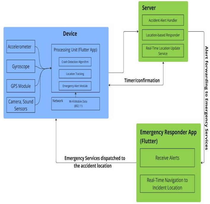
The design process for real-time monitoring and incident detection and resolution consists of three main components: the client device, the server, and the emergency response application. Consumer devices use sensors such as accelerometers and gyroscopes to detect sudden movements that may indicate an accident, while GPS modules provide real-time location information. The device also has a built-in Flutter app that includes collision detection algorithms, location tracking, and emergency notifications. When an incident is detected, the system sends a notification using Wi-Fi or mobile data. The server then processes these reports, maintaining real-time location information, and sending new coordinates in the request response, allowing accurate tracking even if the user is moving behind the scenes.
Emergency response applications are also built on Flutter and can receive emergency alerts and navigation instructions. It uses the server’s location to update in real time to guide responders to the situation, facilitating a fast and accurate response. The system architecture supports effective incident detection, reliable location tracking, and alerting systems that allow emergency personnel to locate and assist emergency personnel.
D. Sensor Data Processing & Accident Detection
Algorithm
1) Data Collection from Sensors
To maximize the system's reach, Flutter is selected as the development platform, enabling the creation of a single codebase for both Android and iOS devices. The system integrates with platform-specific APIs, including the Google Maps API, for precise location tracking and the device's sensor APIs for accurate accident detection.
2) Accident Detection Algorithm:
The core of the accident detection system lies in its algorithm, which filters out false positives (e.g., sudden braking) and focuses on detecting real accidents. The algorithm uses a combination of sensor readings to differentiate between normal driving behavior and accidents. Additional parameters, such as device speed before impact (calculated using GPS), are also considered to ensure accuracy.
E. Emergency Notification
1) Automatic Alert System:
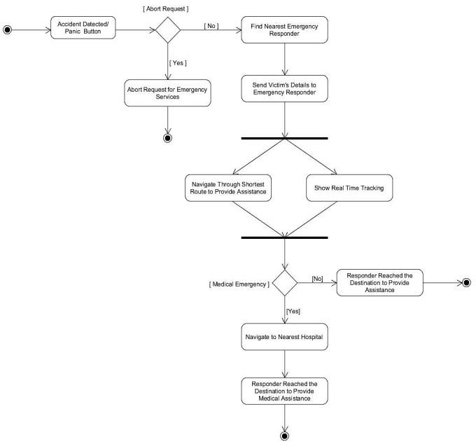
Upon detecting an accident, the system automatically triggers an emergency alert, sharing GPS coordinates with emergency contacts and, optionally, local emergency services.
The message sent includes the precise location of the accident and any additional relevant details, such as the time of the incident.
– DFD 0

Figure 4.1: DFD 0
– DFD 1

Figure 4.2: DFD 1
2) Google Maps API Integration:
The system uses the Google Maps API to provide accurate and real-time location tracking. It also identifies nearby rescue services or hospitals, sending the location details along with the alert to minimize response time.
F. Testing & Validation
1) Simulated Accident Scenarios:
Rigorous testing is conducted using simulated accident scenarios to validate the system's accuracy in detecting accidents and sending alerts. The system's performance is measured against various parameters, such as detection time, accuracy of location, and the system’s ability to filter out false positives.
2) Battery & Performance Optimization
Since the system runs in the background, it is optimized to ensure minimal battery drain and efficient use of resources, making it practical for continuous use on smartphones
3) Key Backend Calculations:
- Accident Detection Based on Accelerometer Data: The core functionality of detecting an accident relies on abrupt changes in motion, which can be detected using the smartphone’s accelerometer.
- Acceleration Formula:
The accelerometer provides readings on three axes: \( X \),
\( Y \), and \( Z \). The resultant acceleration can be calculated as:
 |
- Threshold Detection:
A threshold value for \( a_{total} \) is predefined. If \( a_{total} \) exceeds this threshold (typically above 25-30 m/s²), the system assumes a significant collision has occurred, signaling a potential accident.

- Gyroscope Data to Detect Rotation::
The gyroscope provides angular velocity data that can be used to detect abnormal spins or tilts in the device during an accident.
Angular Velocity Formula:
 |
- Impact Force Estimation:
To estimate the force experienced during an accident, the following formula can be applied:
F = m × a
constantly improved upon through actual usage in real world conditions. There would be specific attention given to audio prompts since user feedback can directly point towards a preference for styles or tones of guidance. Improvements would be done on the algorithms related to object detection based on the user experience in various environments to ensure that the application performs better and uniformly in different settings.
IV. IMPLEMENTATION
A. Release
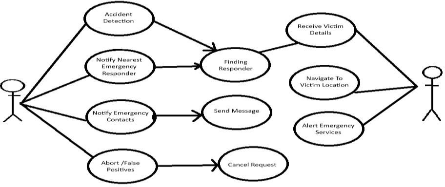
Using smartphone sensors, networking, and real-time data processing, emergency detection and rescue operations are divided into three main areas: consumer equipment, servers, and emergency response applications. This user guide explains the accident investigation and rescue operation, showing how to manage the accident and the next steps for users, emergency contacts, and responders.

- Problem Detection: The first system uses smartphone sensors to monitor for sudden disturbances or rapid changes. When an incident is detected, an alert is triggered.
- Notify nearest emergency personnel: When an incident is detected, the system will attempt to call the nearest emergency personnel. This will help ensure that help is dispatched quickly before the response team, depending on their proximity to the situation.
- Emergency contact notification: At the same time, the system will send an emergency contact notification from the user to notify family or friends. Be aware of the situation and provide additional support if needed.
- Cancel/False Alarm: The system allows users to cancel the alarm at short notice to reduce false alarms. If the user is confident that no incident has occurred, the alarm will be stopped to prevent unnecessary responses.
- Call Responders: The system then searches for available responders on the network. Once detected, the responder will receive a notification and relevant information about the incident to initiate the response process.
- Messages: In cases where direct communication is not available, messages will be sent to responders and emergency responders with the details of the incident and its location.
- Get details of victims: Emergency personnel will receive details about the incident, including the user location and time of detection. This information allows responders to better assess the situation and prepare for their arrival.
- Navigate to victim location: Once alerted, responders can use navigation services to locate the user. This guidance allows responders to get to the scene quickly and efficiently.
- Emergency Alert Service: If first responders are unable to assist or require additional support, the system can forward the alert to emergency services to ensure that service is provided even if it is available.
- Cancel Request: If the user is clear that there is no emergency, they can cancel the notification and prevent further notifications from being sent to the responder or person.
Conclusion
The Collision detection and intelligent rescue systems represent an important step in using modern smartphone technology to improve road safety. By integrating accelerometers, gyroscopes and GPS into the system, the app can instantly detect the situation and receive notifications with precise details of the area for emergency patients. The use of intelligent accident detection and rescue using location tracking devices has proven successful in strengthening road safety and improving procedures in emergency situations. Using the capabilities of modern Android smartphones, the system plays an important role in saving lives by increasing the accuracy of accidents and speeding up rescue operations. Integrating accelerometer and gyroscope data with a real-time operating system, the system can identify emergency situations and ensure timely notifications to emergency personnel and services. In addition, the use of GPS tracking provides important location information necessary for rapid intervention by the rescue team. This approach demonstrates the combination of new technology and security, showing that smart devices can be indispensable in emergency situations. As we have done before, it is important to continue research and development in this area to improve algorithms and increase the reliability of the system. In general, this basic measure aims to ensure that the roads are safer and that help is available when needed.
References
[1] University of the Cumberlands • Department of Information Technology Master of Science “ANDROID BASED ACCIDENT DETECTION AND SMART RESCUE SYSTEM WITH REAL-TIME LOCATION TRACKING”SSRN Electronic Journal ,Association of Academic Researchers and Faculties (AARF) Impact Factor- 5.489 Volume 6, Issue 10,October 2019 [2] UNAIZA ALVI, MUAZZAM A. KHAN KHATTAK,BALAWAL SHABIR, ASAD WAQAR MALIK,AND SHER RAMZAN MUHAMMAD,” A Comprehensive Study on IoT Based Accident Detection Systems for Smart Vehicles”,IEEE Access, 03 July 2020 [3] Goutam Kumar Sahoo; Harshit Srivastava; U. Nirmal Chathura Unagalle; S. Arachchige Pasindu Mihiran; K. Dhananjani Jayarukshi; Santos Kumar Das,” Accident Rescuing System for Vehicles in Road Traffic: A Smart Phone Application”, 08-09 October 2022 [4] A. Khan, F. Bibi, M. Dilshad, S. Ahmed, Z. Ullah and H. Ali, \"Accident detection and smart rescue system using android smartphone with real-time location tracking\", International Journal of Advanced Computer Science and Applications, vol.9, no. 6, pp. 341-355, 2018. [5] N. Girinath, J. D. Kumar, C. G. Babu, S. T. Yahzhini and P. K. Shopika, \"Automatic Alert for Accident Detection and rescue based on Wireless Technology\", 2021 5th International Conference on Intelligent Computing and Control Systems (ICICCS), pp. 211-215, 2021, May. [6] U. K. Singh, S. Yadav, S. Joshi, S. Singh and K. Jayavel, \"Rescue Alert-an accident detection and rescue mechanism\", International Journal of Electrical Computer Engineering, vol. 11, no. 4, pp. 2088-8708, 2021. [7] R. Rishi, S. Yede, K. Kunal and N. V. Bansode, \"Automatic Messaging System for Vehicle Tracking and Accident Detection\", 2020 International Conference on Electronics and Sustainable Communication Systems (ICESC), pp. 831-834, 2020.
Copyright
Copyright © 2024 Prathmesh Tangade, Digambar Bhangale, Aryan Varma, Yogita Dose, Dr. Vinod Wadne . This is an open access article distributed under the Creative Commons Attribution License, which permits unrestricted use, distribution, and reproduction in any medium, provided the original work is properly cited.

Download Paper
Paper Id : IJRASET65875
Publish Date : 2024-12-12
ISSN : 2321-9653
Publisher Name : IJRASET
DOI Link : Click Here
 Submit Paper Online

