Ijraset Journal For Research in Applied Science and Engineering Technology
- Home / Ijraset
- On This Page
- Abstract
- Introduction
- Conclusion
- References
- Copyright
Calculating the Volume of the Sediment Wedge in Retention Check Dams by Using Most Appropriate Models in Jammu and Kashmirs Budgam District
Authors: Dr. Bashir Ahmad Pandit
DOI Link: https://doi.org/10.22214/ijraset.2024.63542
Certificate: View Certificate
Abstract
Though their efficacy is currently under question, check dams are crucial for sediment retention globally. To estimate the retained sediment fast, readily, and with a suitable degree of approximation, 10 geometric models are proposed in this study together with their field technique and equations. The models were used to calculate the volume of trapped silt and compare them with other commonly used techniques on a sample of check dams in the Budgam district of Jammu and Kashmir based on the valley\'s form. Compared to topographic methods, our geometric method produced lesser volumes, but it produced larger volumes than basic methods. As a result, this approach minimizes fieldwork, computations, and expense when used as a preliminary approximation to estimate the sediment trapped by check dams and tiny silted dams. Additionally, compared to the outdated, basic procedures, it enables the selection of a higher precision and better match to the sediment wedge shape.
Introduction
I. INTRODUCTION
High rates of erosion are linked to loose soils (Poesen et al. 2003), which might have detrimental consequences on the drainage network by bringing sediment Because of this, it is predicted that reservoir storage capacity is lost on average by 10% globally, or 0.5% year (Avendano et al., 2000). Therefore, sediment control is crucial to guaranteeing high-quality surface waters. Therefore, retention check dams, also known as small size dams, are typically constructed in gullies, creeks, streams, and rivers worldwide. There is now disagreement about how effective they are calculated that there are only a few million tiny check dams constructed globally. Furthermore, despite a decline in check dam construction in Jammu and Kashmir in recent years, the volume erected in 2002—27201 m3—remains noteworthy. Check dams play a significant role in sediment control; by the end of 1999, about 1246 000 m3 of sediment were held in Jammu and Kashmir according to the Irrigation and Flood Control Department 2022. Once constructed, check dams typically receive little or no maintenance, and their advantages and roles are disregarded. Therefore, it is necessary to assess these works and how they have changed over time, particularly for projects where the function of check dams is called into question. A number of scholars have proposed potential adverse consequences that may arise later on (Castillo et al. 2007; Boix-Fayos et al. 2007; Castillo et al. 2011). According to Conesa-Garc?a & Garc?a-Lorenzo (2009), one of the fundamental elements for evaluating the efficacy of check dams is downstream bed scouring. Check dams are essential for retaining sediment, but their impact needs to be measured.
As a result, several techniques have been developed recently to address the issue of determining the amount of sediment trapped by check dams. While some methods, such prismatic methods (PM) (Romero-D?az et al. 2007; Castillo et al. 2007), are straightforward, others—Sougnez et al. 2011; Bell?n et al. 2011; D?az et al. 2014b—are more intricate because they are based on a thorough topographical survey.
Lastly, different techniques evaluate the silt that has been held over a period of time or sedimentation. However, the complexity, accuracy, and field efficiency of each method differ. Because of this, D?az et al. (2014b) suggested conducting more field measurements using topographical sections in order to increase accuracy. However, compared to the more straightforward methods suggested by Castillo et al. (2007) (Prism method) and Romero-D?az et al. (2007) (Pyramid method), this implies an increase in fieldwork time of between 71 and 93%. Even though it's necessary to ascertain the check dam wedge's exact shape in order to evaluate the retained sediment, these straightforward techniques provide a first approximation, which makes them a compelling substitute when extreme precision is not needed.
In order to calculate the sediment retained by check dams for dry riverbeds (ramblas) or valleys with U-shaped channels and low slopes (<10%), as well as for gullies or V-shaped valleys with prominent slopes (>10%), this study presents a series of straightforward, useful geometric models.
Additionally, we offer instructions on how to conduct field measurements in order to get exact and accurate computations and trustworthy outcomes. A sample of check dams constructed during the hydrological and forest restoration. Approximately 80 years ago were subjected to this set of models in order to evaluate their reliability in comparison to another topographic method that yields more precise and superior field measurements.
II. METHODOLOGY
We offer a simple technique for estimating the amount of sediment that check dams hold. Its foundation is a system that includes the majority of prismatic models discovered in this area of research. We provide a low complexity method using this system of common geometric models, which needs simple fieldwork to acquire an approximate measurement of the volume of confined sediment, which may also be sufficient for exploratory studies. The models that were suggested were derived from field observations of various shapes of sediment wedges among 30 check dams.
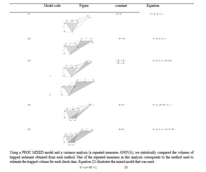
The study regions were categorized according to morphological type: gully areas (G1-G8) and dry riverbeds (called ramblas) (R1-R3). This made it easier to determine which model to use in each situation. The tables provide all of these together with the formulas for calculating their volumes and the requirements for calculating them. Other researchers have made extensive use of two earlier models that were based on the volume of a trapezoidal prism or a pyramid. Nevertheless, in order to acquire a good approximation of the wedge shape, additional geometric models are required, as they don't always accurately reflect the actual situation of the trapped silt.
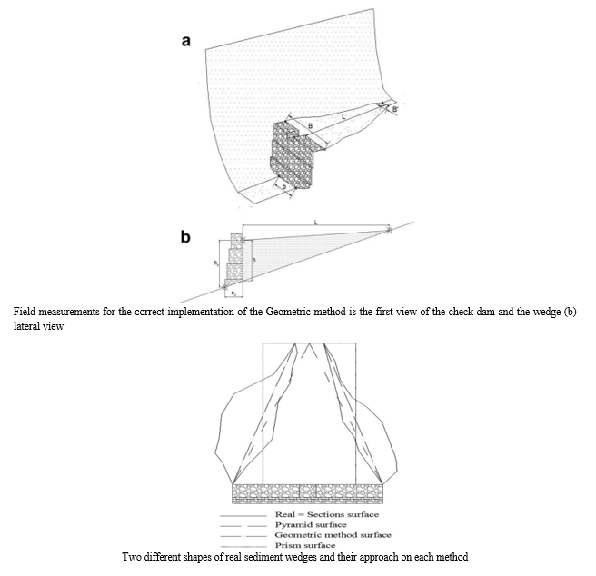
We suggest conducting a low intensity field survey on the essential basic terrain and check dam locations using a total topographic station or differential GPS in order to compute and identify the appropriate model to apply. The study consists of two parts: (1) the upstream check dam, which surveys the cross-section of the sediment wedge directly behind check dam (B), including the midpoint and end points, as well as the final point of the sediment wedge (B0); and (2) the downstream check dam, which surveys the channel width for trapezoidal channel shapes (b) or the mid-channel point, also known as the thalweg for triangular channel shapes. By surveying just these five to seven places, the sediment amount can be found both fast and easily. By connecting the end point of the sediment wedge and the cross-section directly behind the check dam, the horizontal length of the wedge (L) is calculated using graphic design software and the coordinates of the measured locations.
The initial bed slope prior to check dam siltation can then be ascertained by measuring the height of the sediment wedge (h) directly below the check dam and connecting its end point to the downstream channel's midpoint. The height of the sediment wedge (h), which is correlated with the sediment wedge length (L), can be found behind the check dam using equation (1).

where h is the height of the sediment wedge immediately behind the check dam;
hd, the height of check dam wall;
L, the length of the sediment wedge; and
ep is the thickness of check dam wall
Proposed geometric methods to estimate the volume of different sediment wedge types for dry riverbed area, model codes geometric conditions calculation equation

where Vi is the volume of trapped sediment;
l, the general mean;
Mi, the method used to determine the volume (Prism, Pyramid, Sections or GM); and
n is the error term
Errors were independent of the various check dams, normally distributed, and varied from zero for the various methods utilized inside a single check dam. Variances were also obtained for each method.
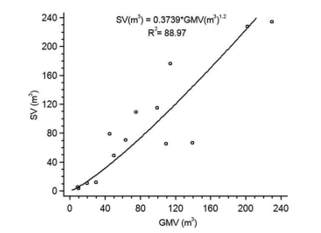
Additionally, we used a regression analysis to examine the relationship between our suggested GM and the SM. In order to determine the relationship between the Geometric models and the most accurate approach with regard to the actual sediment wedge (SM), we thus fitted the equation. The Statistical Analysis System (SAS) software, version 9.2 for Windows, was used for all analyses.
The findings demonstrated that the suggested GM (85.05 m3) was not as effective as the SM (87.89 m3) in terms of mean sediment volume. Our result, however, was superior than the results obtained using the Pyramid approach (64.55 m3) and the Prism method (69.15 m3) (PMs), both of which were lower. As a result, we were able to approximate the most exact volume found by the SM more accurately. However, check dam by check dam, when examining the sediment volume. According to results, employing the SM did not always result in higher volumes than using the GM or PMs. This is the situation with check dams 12, 18, or 21, where the SM and GM diverge further. The reason for this is that the form of the sediment wedge surface is either overstated or underestimated based on how various approaches approach the wedge. Comparing the overall outcomes of each approach, it appears that, as previously documented in studies (Ramos et al. 2013; Dz et al. 2014b), a theoretical error compensation occurs during the calculation of the total sediment volume. However, we saw that the GM had a better error ion than the PMs.


Regression analysis between the volume obtained using the Geometric method (GMV) and the Section method (SV)
These factors consequently raised the value of the confined sediment's volume since they were overlooked in the measurements and computations made using the PMs. We employed the root mean square error (RSME), which computes the difference between the most real volume (SM) and acquired volumes (GM and PMs), to assess the correctness of our method with regard to the PMs. In comparison to the PMs (Prism RSME 5 46.86 m3 and Pyramid RSME 5 48.96 m3), the GM method's RSME value was lower (12.15). It demonstrated that GM provides greater accuracy than PMs. The evaluation of fieldwork performance is a crucial component of using the scheme for improved Geometric models that is presented here. The complete station setup took only ten minutes, and finding and measuring the locations at each check dam required an additional thirty seconds. In the worst-case scenario (5 measuring sites), we calculated that it takes 13 minutes and 30 seconds per check dam; this means that, with the SM, it takes 30 minutes on average per check dam. Additionally, we saw that the results of our fieldwork performance were better than those obtained with the simple PMs. For the Prism and Pyramid methods, the increase in time compared to utilizing the GM was 4 minutes and 51 seconds and 6 minutes and 52 seconds, respectively.
Finally, when we fitted GM and SM using a multiplicative model, we discovered a quite good correlation between them (Correlation coefficient 6 0.821). At a 92% confidence level, R2 equaled 0.643 and was deemed statistically significant (P-value = 0.0001). This showed that when field measurements were properly implemented using GM, the inaccuracy in predicting the volume of trapped sediment was reduced, and the findings stayed quite close to those obtained using methods based on a comprehensive topographical survey. This strategy is consistent with findings from prior research.
As a result, the fitted equation can quickly convert the sediment volumes that were collected with less labor-intensive techniques into ones that resembled those obtained with the SM, which necessitates labor-intensive observations at each check dam. Thus, employing the GM could reduce operating expenses and time while also increasing accuracy through the use of the transformation equation.
Conclusion
The suggested approach is also cost-effective and offers a more accurate assessment of the impact of tiny dams erected in rivers over time and retention check dams utilized in hydrological restoration projects. Additionally, this model strategy corrects some of the incompatibilities observed in previous approaches, enhancing their estimations and bolstering their applicability in these kinds of data. Based on a scheme of geometric figures, the GM suggested in this work is a quick and simple instrument to provide an accurate estimate of the volume of sediment retained by check dams and tiny silted dams. These benefits are mostly attributable to the simplicity of field measurement and computations. Precise techniques utilizing a comprehensive topographical survey, like the SM, are required to ascertain the amount of silt held in check dams with precision. Additionally, the strong correlation between the suggested GM and the SM allows for simple adjustment of the data obtained by the GM, which lowers the expense of fieldwork.
References
[1] Mart?n-Moreno, C., Fidalgo Hijano, C., Martin Duque, J.F., Gonzalez Mart?n, J.A., Zapico Alonso, I. and Laronne, J.B. (2014) The Ribagorda Sand Gully (East-Central Spain): Sediment Yield and Human-Induced Origin. Geomorphology, 224, 122–138. [2] Navarro, J., De Araujo, J.C. and Mongil, J. (2014) Assessment of 80 Years of Ancient Badlands Restoration in Saldana, Spain. ~ Earth Surf. Process. Landforms, 39, 1563–1575. [3] Osti, R. and Egashira, S. (2008) Method to Improve the Mitigative Effectiveness of a Series of Check Dams Against Debris Flows. Hydrol. Process., 22, 4986–4996. [4] Poesen, J., Nachtergaele, J., Verstraeten, G. and Valentin, C. (2003) Gully Erosion and Environmental Change: Importance and Research Needs. Catena, 50, 91–133. [5] Ramos, I., Navarro, J., Bartolome, D., D ?az, V. and Mongil, J. (2013) Control de sedimentos y erosion en la restauraci on hidrologico-forestal de Salda na (Palencia). ~ Actas del VI Congreso Forestal Espanol ~ , Vitoria. [6] Romero-D?az, A. (2008) Los Diques de Correccion Hidrol ogica Como Instrumentos de Cuantificacion de la Erosi on. Cuadernos de Investigacion Geogr afica , 34, 83–99. [7] Romero-D?az, A., Alonso-Sarria, F. and Mart?nez-Lloris, M. (2007) Erosion Rates Obtained from Check-Dam Sedimentation (SE Spain). A Multi-Method Comparison. Catena, 71, 172–178. [8] Romero-D?az, A., Mar?n-Sanleandro, P. and Ortiz-Silla, R. (2012) Loss of Soil Fertility Estimated from Sediment Trapped in Check Dams. South-Eastern Spain. Catena, 99, 42–53. Sas Institute. (2008) SAS/STATVR 9.2 User’s Guide. Sas Institute Inc, [9] Cary, NC. Sougnez, N., van Wesemael, B. and Vanacker, V. (2011) Low Erosion Rates Measured for Steep, Sparsely Vegetated Catchments in Southeast Spain. Catena, 84, 1–11. [10] Verstraeten, G. and Poesen, J. (2000) Estimating Trap Efficiency of Small Reservoirs and Ponds: Methods and Implications for the Assessment of Sediment Yield. Prog. Phys. Geogr., 24, 219–251. Zema, D.A., Bombino, G., Boix-Fayos, C., Tamburino, V., Zimbone, S.M. and Fortugno, D. (2014) Evaluation and modeling of scouring and sedimentation around check dams in a Mediterranean torrent in Calabria, Italy. J. Soil Water Conserv., 69, 316–329. [11] Castillo, V.M., Mosch, W.M., Garc?a, C.C., Barbera, G.G., Cano, J.A.N. and Lopez-Berm udez, F. (2007) Effectiveness and Geomorphological Impacts of Check Dams for Soil Erosion Control in a Semiarid Mediterranean Catchment: El Carcavo (Murcia, Spain). Catena, 70, 416–427. [12] Castillo, V., Boix-Fayos, C., Vente, J. de, Mart?nez, M. and Barbera, G. (2011) Efectos Del Aumento de la Cubierta Vegetal y los Diques de Correccion en la Producci on de Sedimentos de Cuencas Mediterraneas. Cuadernos de la Sociedad Espanola de Ciencias Forestales ~ , 32, 153–158. [13] Catella, M., Paris, E. and Solari, L. (2005) Case Study: Efficiency of Silt-Check Dams in the Mountain Region of Versilia Basin. J. Hydraul. Eng., 131, 145–152. Conesa, C. and Garc?a, R. (2007) Litofacies de Relleno y Modelo de Sedimentacion de Los Diques de Retenci on en el Tramo Inferior de la Rambla Del Carcavo (Cuenca del Segura). Rev. C & G., 21, 77–100. [14] Conesa-Garc?a, C. and Garc?a-Lorenzo, R. (2009) Effectiveness of Check Dams in the Control of General Transitory Bed Scouring in Semiarid Catchment Areas (South-East Spain). Water and Environ. J., 23, 1–14. [15] D?az, V., Mongil, J. and Navarro, J. (2014a) Propuesta de Una Nueva Metodolog?a Para Determinar la Efectividad de Los Diques en la Retencion de Sedimentos. Cuadernos de Investigacion Geogr afica , 40 (1), 169–190. [16] D?az, V., Mongil, J. and Navarro, J. (2014b) Topographical Surveying for Improved Assessment of Sediment Retention in Check Dams Applied to a Mediterranean Badlands Restoration Site (Central Spain). J. Soils Sediments, 14, 2045–2056
Copyright
Copyright © 2024 Dr. Bashir Ahmad Pandit. This is an open access article distributed under the Creative Commons Attribution License, which permits unrestricted use, distribution, and reproduction in any medium, provided the original work is properly cited.

Download Paper
Paper Id : IJRASET63542
Publish Date : 2024-07-03
ISSN : 2321-9653
Publisher Name : IJRASET
DOI Link : Click Here
 Submit Paper Online

