Ijraset Journal For Research in Applied Science and Engineering Technology
- Home / Ijraset
- On This Page
- Abstract
- Introduction
- Conclusion
- References
- Copyright
Case Study of Traffic Control and Improvement Measures
Authors: Vikram M K, Aparna B P, Roopakala C G
DOI Link: https://doi.org/10.22214/ijraset.2024.66059
Certificate: View Certificate
Abstract
The objective of this study is to identify factors impeding traffic mobility and propose measures to improve the prevailing traffic conditions duly planning for the future keeping in view the growth pattern and the socio economic scenario envisaged.
Introduction
I. APPROACH AND METHODOLOGY
A methodology for the Study has been evolved giving due consideration to:
- Study Area Demographic and Travel Characteristics.
- Project Challenges.
- Issues and Concerns of all project stakeholders.
A systematic, phased and integrated approach will be adopted for conducting the study and delivering the results within the stipulated timeframe. The study will be conducted in three Phases:
- Phase 1: Inception & Surveys
- Phase 2: Planning of short term measures
- Phase 3: Planning of Medium & Long term measures
The Phase-wise methodology is explained in the sections below:
Methodology
A. PHASE -1: Inception & Surveys
1) Mobilization and Reconnaissnace:
Mobilisation of the Team :
During the mobilisation period, a detailed work program will be prepared. During the project, the weekly progress of work will be measured and compared with the planned work.
Meeting the Client :
Consultants have already visited the place and have had a preliminary understanding of the current traffic transport system, the problem areas etc. A good rapport and periodic contact with the client will be maintained throughout the study period.
2) Surveys
Traffic Surveys :
Good and adequate data is a prerequisite for any planning study. All aspects of the field process adhere to pre set norms and standards - recruitment, briefing & training, accompaniment, back check, back check by supervisor, and scrutiny.
The following surveys shall be undertaken to develop/ update the traffic and transportation data for the study:
3) Traffic Volume Counts:
Objective of the Survey:
The main objective of the survey is to estimate the classified vehicular volumes crossing the screen lines to be used for validation of the transport model.
Scope of Survey:
Defining the screen lines and designating the traffic count stations.
Counting of vehicles classified by the type of vehicle crossing the screen lines.
Conduct of the Survey:
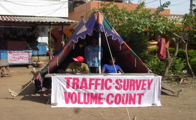
Manual traffic counts will be carried out at all locations where the road network cuts across the screen lines. Traffic counts will be carried out on a typical working day for 16 hours covering both peak and off-peak periods. At each identified station, both directional counts will be carried out by vehicle type. i.e; cars, jeeps, vans, buses, trucks, MAV’s, LCV’s tractors, motorised two wheelers and three wheelers, and slow moving vehicles. The locations are as indicated in Figure.
Data Entry and Analysis:
The traffic data collected from the field will be scrutinized and processed. The Passenger Car Unit (PCU) values recommended by Indian Roads Congress (IRC) will be used in the analysis. All results will be presented in tabular forms in a spreadsheet. The results of traffic survey will be presented for each count station.
Key Outputs:
Peak Hour Volume across the screen lines (Vehicle/Hr. and PCU/Hr)
Traffic by Vehicle type and hourly distribution of Traffic
Screen line flows
Pedestrian Count Surveys:
Pedestrian count data will be used frequently in planning applications. The data collected will be used to evaluate sidewalk and crosswalk needs, to justify pedestrian signals, and to time traffic signals. Pedestrian counts will be carried out at intersection crosswalks, midblock crossings, or along sidewalks for a period of six hours covering peak periods.
The survey may also be carried out at places where in the pedestrian facilities are provided like the subways, foot over bridges etc as existing in the study area.
Data from the Pedestrian traffic counts conducted at several locations on the selected stretches in the study area where pedestrians are exposed to risk of accidents will be determined. The stretches from the analysis where the movement of the pedestrians is high will be marked and presented in a map. This will enable in identification of the High Risk Pedestrian Zones in the study area and will enable in improvement options for pedestrian facilities in the study area.
Parking Surveys:
Consultants propose to conduct primary parking inventory surveys and parking space utilisation surveys to assess the existing parking demand. The existing demand for on-street parking facility will be determined by patrolling the parking area at regular intervals through a period covering the peak and off peak periods. The length of the road covered by a patrol (mobile monitoring team) will be limited by speed of walking and the frequency of patrol. The length of the road/street will be chosen such that the frequency of patrol is 30 minutes. The information collected will include time and the registration numbers of the vehicles. This survey will be conducted for a twelve hour period.
The survey in off-street parking locations will be carried out by noting the registration numbers of the vehicles and the time of entry and exit of the facility.
Parking utilisation refers to the extent to which the parking facility is being used. The analysis of parking accumulation and occupancy counts (this analysis will be made for the surveys carried out at the unauthorised parking areas also) will yield the following measures of parking utilization:
- Parking Accumulation.
- Parking Space Turn Over.
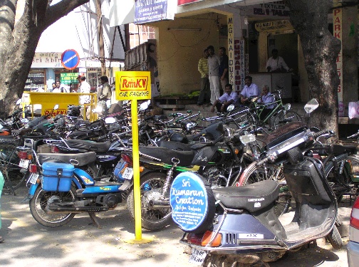
Parking accumulation refers to the total number of parked vehicles occupying spaces in the parking facility over a period of time. The time period usually adopted is one hour. The hourly variation in accumulation will be represented graphically as “Parking accumulation diagram”. The demand for parking by various types of vehicles will be assessed at each of the identified locations, which include peak demand, off peak demand in a day. From the nature of demand, the measures to solve the parking problems will be identified. The on-street parking locations will be marked on a map to enable the identification of the parking locations which will be used in deficiency analysis. Tentative locations identified are shown in Figure.
2) Road Network Inventory:
Need for the survey:
The main purpose of the field inventory will be to make a record of the existing conditions of the road network to be considered as base year transport network.
Methodology:
After having studied the existing available data and in depth discussions with relevant officials in concern with the study area and a detailed reconnaissance undertaken, a field inventory of the road network in the study area will be carried out. Consultants propose to use majority of this data from the past study reports and available commercial maps.
The following data will be collected during the field inventory survey –
Effective Road width.
No of lanes.
Availability of median, shoulder etc.
Parking along the road.
Adjacent land use.
Existing speed limit sign boards etc.
A team of three enumerators each shall traverse the road network with a specified format for the purpose of recording the data.
Network inventory will be collected for all arterial roads and sub-arterial roads in the city.
Use
To develop the base year network facilitating both qualitative and quantitative evaluation of the present sufficiency of road networks vis-à-vis existing standards and usage pattern.
B. PHASE 2: Planning Of Short Term Measures:
Based on the study of the existing traffic conditions and from survey data, we would identify the problematic areas. Hence, short term solutions based on the kind of problems shall be suggested. The suggestions made will not involve land acquisition, or it will be limited to a bare minimum. The improvement measures would generally maximize the utilization of the existing facilities, thereby providing low-cost traffic solutions. For example:
- Traffic weaving and congestion: Junction & improvements can be suggested. Introducing regulatory measures for controlling mixed flow of traffic. Managing freight movement by introducing special schemes for their entry and exit, like banning their entrance into the city cordon etc.
- Traffic congestion at major corridors: Suggestion of Street Parking locations & preparation of plans for critical areas. Installation of traffic control devices, introducing traffic management schemes and proposing locations for the placement of street furniture like road signs etc.
- Non-motorists (Pedestrians, bicycle users & other vulnerable road users) accidents: Improvement plans for pedestrian facilities and right of way for bicycle users, cycle rickshaws / etc, to guard their safety and to help their mobility.
C. PHASE 3: Planning Of Medium & Long Term Measures:
Once the traffic modeling Phase is complete, the total transportation demands, both for Passengers & Goods traffic (intra & inter zonal traffic) can be estimated. Based on this we would identify the deficiencies in the road network.
Medium term measures means, a proposal which would last for about 5-10 years time duration and this may involve land acquisition, relocation etc.
Long term measures are the developments that are required beyond the horizon period 2023 based on the projected demand.
Medium term Measures:
The medium term measures will broadly include:
Widening & strengthening of existing road network
Identify the missing road links, which can help to ease the traffic movement
For the through intercity traffic, identify the need for bypasses or the need for another one when it has out lived its purpose as in the case of this town
Augmentation of mass transport services.
Regulation and reorganization of IPT sector.
Development of integrated bus/IPT route system.
Long Term Measures:
The long term proposals covers planning of future transport development & network improvements such as development of parallel & transverse road corridors, bypasses for inter-city key corridors. It also will concentrate on pedestrian facilities like underpasses, grade separated interchanges, integrated terminals for passengers & goods etc.
Alternative forms of mass transport systems like Exclusive bus lanes, BRT, Light Rail Transit etc.
Study and choice of the systems
Planning Multi-Modal systems
Financial appraisal and Financial structure for implementation mechanism
Traffic management and road safety improvement training to be held for engineers, staff of municipality.
D. Traffic Problems And Deficiencies
Based on reconnaissance, the traffic problems perceived in the town in general are as given here under:
Facilities to pedestrians are seen to be neglected and remain a largely unaddressed problem. There is no footway and the areas at the edge of the carriageway are encroached forcing the pedestrians to spill over on to the carriageway.
The heterogeneity of the traffic adds to the problems of mobility with a sizeable number of slowing moving vehicles like bicycles and consuming the majority of the road space.
Increased ownership of private vehicles particularly motorized two wheelers is a prime contributor to traffic congestion and also has an impact on public transport patronage.
The growth of population in outlying areas and the dispersal of job Potential have placed the transport infrastructure under considerable strain.
The mushroom growth of auto rickshaws has impeded traffic mobility further.
Traffic congestion was noticed in the vicinity of the bus terminal and there is a need for improvements to the traffic situation at this location.
Central median for segregating the directional traffic is found wanting although a few roads are wide enough.
As the road system has not grown commensurate to the vehicle growth, traffic congestion is observed on many links. Traffic congestion is indicative of one such deficiency whereby an increased travel time and a reduction in efficiency particularly in the peak period is felt.
Several roads do not lend themselves for substantial improvements due to constraints of land space and the areas being heavily built up.
The frontage of the areas in the busier sections of certain roads has Commercial land use and the establishments do not provide for parking Place within their premises. Individuals owning vehicles tend to park in the vicinity of their place of visit and in the absence of parking facility in the complex; the vehicles are parked on the carriageway. As these vehicles consume valuable road space, the capacity of the link gets reduced besides they interrupt the free flow of vehicles causing traffic congestion and endangering road safety.
It is at the intersections wherein the chances of accidents are high and therefore geometrics of intersections assume significance due to the fact that the efficiency of operation speed safety and capacity are directly governed by the design. As the flow in various arms of the intersection involves conflicts, its proper design and traffic control can effectively reduce accidents and delay to traffic.
The problems arising due to roadside encroachments.
Bus stops are seen to be located too close to intersections.
Building abutting the major arterials, depriving of scope for widening.
Road signs and road markings are seen to be deficient.
II. DATA ANALYSIS
A. Traffic Volume Counts:
The classified traffic volume counts carried out at various count locations has been carried out to work out the traffic characteristics such as,
Traffic composition.
Hourly variation and Peak Hour share.
Directional distribution.
The various vehicle types having different sizes and characteristics were converted into equivalent passenger car units. The Passenger Car Unit (PCU) factors recommended by Indian Road Congress in “Guidelines for Capacity of Urban Roads in Plain Areas” (IRC-106-1990) have been used for conversion, and are presented in Table.
Table: PCU Factors Adopted for Study as per IRC.

III. TRAFFIC IMPROVEMENT MEASURES
With a view to improve the traffic situation without extensive investments and manage with the infrastructure facilities in the short time frame, all these Recommendations should be based on the reconnaissance from the field Survey. Care is taken to ensure that the implementation of these proposals require nil or minimum land acquisition.
A. Short Term Measures
1) Junction Improvements
Road intersections are substandard in terms of turning radius with the traffic police, post or rotary located eccentrically. Hence, it is very critical that the intersections be properly designed. As such it is very critical that the intersections be properly designed.
The reconnaissance survey as well as the topographic surveys was done on the major junctions to know the present geometrics, the availability of sight distance, the signs, markings etc. It was observed that the junctions were not up to the standards. So the following improvements were suggested at junctions as part of medium term recommendations:
Providing adequate corner radii.
Providing sufficient turning radii.
Flaring approaches towards intersections.
Providing channelizers / division islands.
Providing signs / lane markings / lighting.
2) Parking Strategy
An appropriate parking scheme should be evolved for maintaining the unique, economic, social, and environmental character of the place.
Proposal for parking strategies should consists of the following objectives:
Minimizing the harm to local businesses that depend upon visitors to the area.
Maintaining continued reasonable level of access to the attractions of the area and facilitate all types of short term visits to the area.
Achieving comprehensive rather than piecemeal improvements to avoid the problems.
Be simple to introduce, to understand, and to manage.
Be flexible enough to adjust to changing circumstances.
Keeping the above objectives and specific parking needs, the following Recommendations are made:
3) Parking Regulations and Enforcement
It is recommended that strict parking enforcements should be carried out by patrolling police to prevent haphazard parking. It is also a good idea to introduce limited time parking scheme or a paid parking facility with a view to discourage long term parkers on this road. Parking should not be permitted in front of the driveways from the houses and other buildings.
4) Pedestrian Facilities
Short-distance pedestrian trips are performed by all sections of society. As is the case with many urban centers where in provision of pedestrian facilities is the most neglected aspect of transportation infrastructures, that place also lacks proper facilities for pedestrians even though footpath exists on some sections of roads.
A zebra crossing for pedestrians is good in theory, but it has been observed that most drivers do not give right-of-way to pedestrians. Therefore enforcement is necessary to ensure the safety of pedestrians. In order to ensure smooth and safe Pedestrian movement with passage of time some of these zebra-crossing facilities need up gradations to pedestrian signals and later to a grade separated pedestrian facility like Subways. The authorities should ensure that footpath is available for walking and not for hawkers. It is also recommended to provide guard rails near the junctions.
5) Traffic Segregation
There is a need to segregate the traffic by space and time. In the first instance, there is a need for segregating the pedestrians from the general traffic stream by providing footpath and guard rails.
6) Traffic Control Devices:
When properly used, traffic control signals are valuable devices for the control of vehicular and pedestrian traffic. They assign the right-of-way to the various traffic movements and thereby profoundly influence traffic flow. Traffic control signals that are properly designed, located, operated, and maintained will have one or more of the following advantages:
They provide for the orderly movement of traffic.
They increase the traffic-handling capacity of the intersection.
They reduce the frequency and severity of certain types of accidents, especially right-angle collisions.
They are used to interrupt heavy traffic at intervals to permit the pedestrians to cross the road.
7) Traffic Signs and Markings:
Traffic signs are devices placed along roadway to guide, warn, and regulate the flow of traffic. Traffic signs perform a number of functions, of which few are listed below:
They give timely warning of hazardous situations when they are not self evident.
They are of great help in regulating traffic by imparting messages to the drivers about the need to stop, give way and limit their speeds.
They give information as to highway routes, directions and points of interest.
In general, it was observed that the traffic signs are found wanting in that particular place. It is recommended that proper signs be installed at appropriate locations. Road signs are classified into three categories:
Mandatory/Regulatory Signs
Cautionary/Warning Signs
Informatory Signs
All the traffic signs should be facilitated as per the guidelines provided in IRC publication 67-2001 “Code of Practice for Road Signs”.
Road markings are important on roads and intersections as they promote road safety and bring about smooth and harmonious flow of traffic along guided paths of travel. The main advantage of the road markings is that they convey the required information to the driver without distracting his attention from the carriageway.
The following road markings are proposed:
Stop Lines.
Traffic Lane lines.
Pedestrian Crossings.
Parking Bays.
Bus Bays.
8) Traffic Management Schemes:
Relocation of Bus Stops:
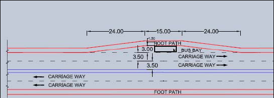
Many of the bus stops are located immediately after major junctions and no recessed bus bays exist. There are several instances when the buses are forced to stop in the middle of the road and having the queues behind the buses spilling back up to the junctions and disrupting the regular vehicular movement at the junction.
It is recommended that the bus stops be moved at least 60 meters away from the junction and wherever feasible to provide a bus lay by. A typical Bus bay is as shown below.
Accident Prevention:
Poor road geometry and inadequate street lighting along with limited road space and lack of traffic sense both to drivers and pedestrians increase the incidence of accidents. Mainly they are caused due to the casual approach of the road users towards driving rules, safety precautions, and regulations.
With the view of curbing accident hazard, the Traffic Police should identify Accident Zones. Road improvement measures should be designed by Municipality Engineering Staff for implementation which includes upgrading street lighting and junction geometry, provision of cannalization and guard rails for pedestrians, construction of speed breakers etc.
B. Medium / Long Term Measures
1) City Bus System:
For an urban transportation to be sustainable there should be a proper number of public and private modes of transport. IPT’s and personalized vehicles consume a good amount of road space but are capable of moving only a very limited people. From the ‘Mobility’ aspect public transport system is very essential for any city/town. Hence, public transport is needed where people have the only option of using private vehicles/IPT to a large extent to travel.
Bus service is needed for the following reasons:
Control the growth and usage of private vehicles on city roads
Reduction in congestion, pollution etc.
Reduction in Parking Problems.
2) Other Medium Term Measures:
Road Safety Public Campaigns:
Periodic road safety public campaigns including exhibitions, lectures and film shows are also necessary for road user education. The municipality should approach the NGO associations and look for sponsors and volunteers for such Drive / campaigns.
The Road Safety programs should be aimed principally at adult road users and serve three main purposes:
To inform the public of new regulations or changes to the traffic regulation System.
To influence the attitudes towards road safety.
To persuade road users to change their behavior in relation to identified causal factors in road accidents.
Benefits:
Improves road sense among the users.
Better enforcement.
Road User Education:
It has been noticed that overall awareness of the traffic discipline and compliance with the traffic rules by road users is much below the desired level. At present, Traffic Police will have to offer positive leadership in this direction to make people responsible and rule abiding road users. Special traffic drives are to be planned by them for making the public aware of the traffic rules. Also imposing fines at the spot procedure for defaulters may be reviewed in view of large backlog of pending traffic offence cases.
Strengthening Of Traffic Personnel & Enforcement Equipments:
Providing proper infrastructure / road furniture and educating the drivers to follow and respect the traffic rules is one thing, but strict enforcement is what really matters when it comes to safe driving habits.
The traffic police were found to regulate the traffic at critical junctions in the place. After the junction improvements are made and a few signalized, the police could be used for the enforcement activity. If deemed necessary, the department should be strengthened. The traffic police division should also be provided with enough numbers of necessary equipments like speed radar guns, patrol vehicles etc. for better enforcement. Spot fines for the traffic offenders would also be a deterrent and would ensure better road discipline.
Roadway Improvements:
The following long term improvements are recommended:
Road widening.
Central median.
Paving shoulders.
Black topping metalled roads.
Drains.
Street lighting.
IV. IMPLEMENTATION
A. Coordination
The responsibility of taking care of traffic engineering does not lie with just one entity or organization. Coordination and cooperation among various entities are required for the effective traffic management towards achieving the desired results. In this regard, there must be a coordinated effort from the following in the place:
The city Municipal Corporation
The city Traffic Police
The city Municipal Transport Corporation
The Regional Transport Authority
The Road Safety Council
The State or National Highways
The ideal scenario would be the one where all the authorities like the Corporation, Police, the Transport Corporation, and State Highways etc. would work in coordination with one another in order to sort out any traffic related issues.
The city Municipal Corporation is responsible for providing the infrastructure required for the traffic movement.
The city Traffic Police is responsible for managing the traffic movement through the town.
The other agencies like the RTO etc. play only a minor role as far as the town related issues are concerned.
A committee could be formed to look into all the traffic related matters with members from all the concerned stake holders. The committee could be lead by either the Commissioner of the Corporation or the Police and have a working team which could have hands on the on ground problems.
B. Advertisements
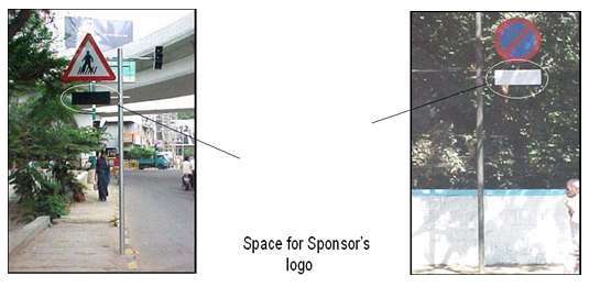
There are possibilities that funds for traffic improvements could be tapped from Advertisements like bill boards and promoting sponsor’s logos on traffic sign boards.
V. TRAFFIC FORECASTING
A. Need
To plan the construction of a new facility of the improvement of existing facilities.
Accurate estimate of future traffic will influence the engineering design of the facility and the economic decision whether to take up the project or not.
B. Data for estimation
Data on traffic flows.
Capacities of different links in the network.
Locational pattern of future projects of potential traffic generation etc.
C. Improvements
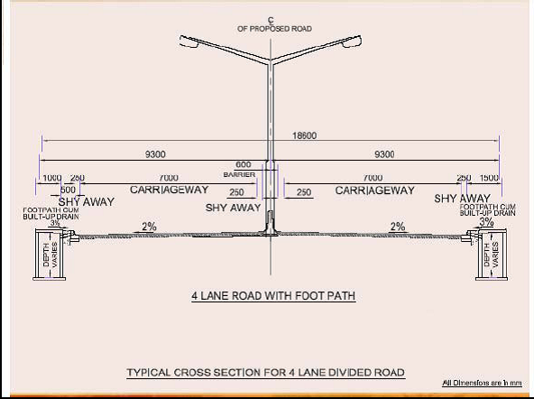
According to IRC 64-1990 such a section of road has a capacity of 15000 PCU/day. If the actual traffic runs beyond the capacity of the road. The capacity of the road can be increased by providing paved shoulders. This increases the traffic handling capacity of the road by 15%. By keeping in mind all the realistic data obtained and by anticipating the future growth of traffic, a four lane carriageway with unpaved shoulders which can carry 35000 PCUs/day, would conveniently cater to the needs of the road section.
A typical cross section for 4 lane divided road is given in figure.
The following improvements are recommended:
Road widening.
Central median.
Paving shoulders.
Black topping metalled roads.
Drains.
Street lighting.
Conclusion
1) Traffic forecasts for improvement of junctions and impr0vement of roads for free flow of traffic. 2) Improvements to roads like widening, provision of footpath, drains, bus-bays etc for smooth flow of traffic. 3) Parking surveys indicated the necessity of organised parking. 4) Pedestrain facilities like sky walk may be recommended at some locations for the safety of road users. 5) Overall smooth flow of traffic network for the future traffic of city with improvements to junctions.
References
[1] ‘Highway Engineering’ by Khanna and CEG Justo, Nem Chand & Brothers, Roorkee (UP) (Eight Edition) 2001. [2] IRC: 65-1976 for Recommended Practice for Traffic Rotaries. [3] IRC: 103-1988 for Guidelines for Pedestrian facilities. [4] IRC: 92-1985 for Guidelines for the Design of interchanges in Urban Areas. [5] IRC: 99-1988 for Tentative Guidelines on the provision of Speed Breakers for Control of Vehicular Speeds on Minor Roads.
Copyright
Copyright © 2024 Vikram M K, Aparna B P, Roopakala C G. This is an open access article distributed under the Creative Commons Attribution License, which permits unrestricted use, distribution, and reproduction in any medium, provided the original work is properly cited.

Download Paper
Paper Id : IJRASET66059
Publish Date : 2024-12-22
ISSN : 2321-9653
Publisher Name : IJRASET
DOI Link : Click Here
 Submit Paper Online

