Ijraset Journal For Research in Applied Science and Engineering Technology
- Home / Ijraset
- On This Page
- Abstract
- Introduction
- Conclusion
- References
- Copyright
A Comprehensive Study on Detection of Water Bodies using Satellite Imagery
Authors: Dr. Rajkumar L. Biradar, Akhila Mucharla, Sowmya Thatipalli, Sathvika Adepu, Pujitha Mandava
DOI Link: https://doi.org/10.22214/ijraset.2024.61706
Certificate: View Certificate
Abstract
Satellite imagery plays a crucial role in overseeing and safeguarding natural resources, particularly water bodies like lakes, rivers, and oceans, which hold significant environmental and human value. Detecting water body pixels in satellite images is a key aspect of environmental management and planning. Recent advancements in deep learning, particularly convolutional neural networks (CNNs) and recurrent neural networks (RNNs), offer promising solutions for tasks like object detection and segmentation in image processing. This study leverages CNNs and RNNs to precisely identify water body pixels in satellite images, aiming to develop a model capable of accurately distinguishing between water and non-water pixels. Such a model holds practical significance for environmental monitoring and management efforts.
Introduction
I. INTRODUCTION
Identifying water bodies in satellite imagery is crucial across various fields like environmental monitoring, disaster management, and urban planning. Traditionally, this task relied on manual interpretation or spectral indices, which are time-consuming, labor-intensive, and prone to errors. In contrast, deep learning methods offer a groundbreaking alternative, automating the process and improving accuracy significantly.
The main goal here is to develop a robust model for automatically detecting water bodies in satellite images. The potential impacts are extensive, including monitoring water resources, pinpointing changes in water bodies, planning flood control measures, and assessing climate change effects on aquatic systems.
Deep learning brings a host of advantages to the table when applied to water body identification. Its automated nature expedites the process, eliminating the need for extensive human intervention and reducing time consumption. Moreover, it substantially curtails the subjectivity inherent in manual interpretation, ensuring consistent and objective results.
Furthermore, the scalability of deep learning algorithms equips them to handle voluminous datasets and facilitates the continuous monitoring of water body dynamics and changes over time. This synergy between the efficiency of deep learning and the wealth of available satellite data promises valuable insights into water body distribution and behavior, ultimately enhancing the management of environmental resources, urban planning, and hydrological research through more accurate and efficient means of water body identification in satellite imagery.
II. LITERATURE SURVEY
A. Utilizing Deep Learning for Detecting Water Bodies in Satellite Imagery
Advancements in surface water detection utilize various sensors such as optical and microwave sensors, including LANDSAT and Sentinel-2 data. Microwave sensors like Synthetic Aperture Radar (SAR) penetrate clouds and vegetation for day and night monitoring.
Optical sensors offer high spatial and temporal resolutions. Techniques like NDWI and MNDWI extract water from optical images, while SAR mitigates cloud cover issues. Data from satellites like Quickbird and IKONOS are chosen based on water body scale. Integration of UAV data enhances water body extent precision.
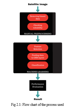
Satellite image dataset analysis involves data preprocessing and neural network training. Preprocessing includes dividing data into 85% training and 15% testing sets, enhanced by shape file mapping for accuracy. The neural network comprises a 64x6 convolution filter layer with rectified linear activation, addressing gradient issues. Max pooling reduces feature map dimensions, and SGD with parameters like learning rate and momentum handles classification. The model achieved 96.38% accuracy, varying with data content and image resolution. Training time depends on computational power.
- Advantages
- Accuracy: CNN-based methods often achieve high accuracy in detecting water bodies, thanks to their ability to learn intricate patterns and features from satellite imagery.
- Scalability: Deep learning models can be scaled to process large volumes of satellite data efficiently, making them suitable for monitoring vast areas and providing near-real-time insights.
2. Disadvantages
- Overfitting: CNN models are susceptible to overfitting, particularly when the training dataset is limited or not representative, resulting in a lack of effectiveness when applied to new, unseen data.
- Data Requirements: Deep learning models require large and diverse datasets for training, which may be challenging to obtain and label accurately.
B. Monitoring water resources using satellite images through Convolutional Neural Networks (CNNs)
Employing a perceptron algorithm, this study extracts water constituents from Landsat imagery using feature vectors. These vectors, combined with weights, shape a dual threshold function incorporating water body characteristics like low SWIR reflectance and a modified aqua index. This method efficiently distinguishes water from land features, promising automated extraction of water constituents for enhanced water resource management and environmental monitoring.
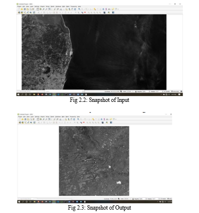
The project employs machine learning to monitor surface water bodies, favoring automated extraction from satellite images. It utilizes ISRO's Bhuvan geoportal for data collection, followed by cleaning, normalization, and labeling for AI training.
Convolutional Neural Networks (CNNs) analyze images, while Geographic Information Systems (GIS) aid in water resource management. Modules like Rasterio, GDAL, TensorFlow, PyRSGIS, and Pandas handle data processing, leading to a graphical display of the neural network's performance. The project aims to enhance water constituent analysis in satellite imagery through advanced technology.
- Advantages
- High Accuracy: CNN models can achieve high accuracy in detecting water bodies, making them suitable for precise monitoring.
- Automation: Upon deployment, CNN-based systems can automate ongoing water resource monitoring, diminishing reliance on manual intervention.
2. Disadvantages
- Interpretability: CNN models are commonly seen as opaque, posing difficulties in comprehending their decision-making mechanisms. This lack of transparency can pose challenges in applications where interpretability is crucial.
- Overfitting: CNN models can overfit the training data if not properly regularized, leading to poor generalization on unseen data.
C. An Innovative Approach to water detection in multispectral images, utilizing data simulation and Random Forest
Surface water bodies, crucial resources affected by climate and land use changes, pose challenges for traditional monitoring methods. Remote sensing, particularly satellite imagery and water indices, has transformed their mapping. However, fixed threshold values for water indices hinder accuracy across diverse scenes. A novel approach integrating hyperspectral data and simulation mitigates this issue, validated across various spectral resolutions and timeframes using AVIRIS, Sentinel-2, and Landsat 8 OLI imagery, enhancing mapping precision and efficiency.
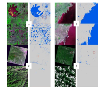
Fig 2.4: showcases water body results from two Sentinel-2 scenes and two Landsat 8 scenes. (a) depicts a Sentinel-2 scene from T51RTQ on May 3, 2020. (b) shows another Sentinel-2 scene from T50SQE on February 26, 2020. (c) presents a Landsat 8 scene from p125_r038 on December 4, 2013. (d) displays a Landsat 8 scene from p119_r027 on October 2, 2017.
This study's methodology included constructing a hyperspectral sample dataset from 36 AVIRIS images, encompassing various water and non-water features. Data simulation converted hyperspectral to multispectral data for sensor compatibility. Feature extraction employed 12 spectrum features for classification, including reflectance and vegetation and water indices. A Random Forest classifier with optimized hyperparameters was utilized, followed by accuracy assessment using metrics like overall accuracy and F1 score to evaluate water detection effectiveness.
- Advantages
- Accuracy: Random Forest models are known for their accuracy and robustness in classification tasks, making them suitable for reliable water detection.
- Applicability: This approach can be applied to multispectral images from different sources and environments, making it versatile for various applications, such as remote sensing and environmental monitoring.
2. Disadvantages
- Dependency on Simulation Quality: The system's effectiveness is closely tied to the precision and quality of the data simulation process. If the simulations are inaccurate, it can result in subpar performance of the model.
- Computational Resources: Training Random Forest models may demand substantial resources, especially when dealing with extensive datasets, possibly necessitating robust hardware for optimal performance.
- Limited Interpretability: Random Forest models are known for their accuracy but are often perceived as black-box models, posing challenges in understanding their decision-making mechanisms.
D. Identification of Water Bodies using Color Component Analysis combined with Morphological Operations
In color image representation, the RGB model is prevalent, with each pixel comprising three components: red, green, and blue, ranging from 0 to 255. This model requires 24 bits per pixel, determining the pixel color. Image erosion and dilation, fundamental in image processing, refine results by eliminating small components and enlarging them, respectively, using a structuring element. These operations are employed in the proposed scheme to adjust image features.
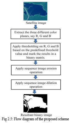
The proposed water body detection algorithm analyzes color data, particularly red and blue components, from satellite images. It consists of three algorithms: Algorithm I determines threshold values using water body images; Algorithm II generates binary images representing water regions; morphological operations enhance results. Algorithm III assesses performance by comparing output with ground truth masks, computing accuracy, precision, and recall to evaluate water body identification accuracy.
- Advantages
- Remote Monitoring: Facilitates tracking surface water extent across vast and frequently unreachable regions, supplying vital data for diverse applications such as environmental management, disaster response and agriculture.
- Timely Information: Satellite-based detection offers near-real-time or historical data, allowing for the tracking of changes and trends in surface water extent over time.
2. Disadvantages
- Limited Resolution: Satellite imagery may have limited spatial resolution, making it challenging to detect small or narrow water bodies accurately.
- Cloud Cover: Cloud cover can obstruct satellite imagery, leading to gaps or inaccuracies in the data.
- Data Processing Complexity: Data preprocessing and analysis can be complex, requiring specialized software and expertise in remote sensing.
F. Support Vector Machine for Remote Sensing using Satellite Images
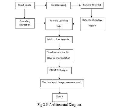
Shadows in images impact quality, hindering segmentation and object detection. Classified as soft or hard based on density, they affect accuracy. A proposed method integrates native patch data with boundary info, using Support Vector Machine (SVM) for binary classification. Conditional Random Field (CRF) models refine labeling and eliminate outliers. This enhances shadow detection and removal, crucial in remote sensing and medical imaging.
The method proposed includes a replacement technique for estimating shadow presence and an automated shadow removal process using shadow matte extraction. The percentage difference between the shadow-eliminated and input footage is calculated using Grey Level Co-Occurrence Matrix (GLCM). Preprocessing involves denoising satellite images for improved quality and bilateral filtering for edge preservation. Support Vector Machine (SVM) classifiers learn features at the super pixel level, enhancing shadow detection accuracy. Quantitative analysis demonstrates notable enhancement in image quality following shadow removal.
- Advantages
- High Accuracy: SVMs are renowned for their capacity to attain superior classification accuracy, rendering them well-suited for remote sensing applications where precision holds paramount importance.
- Effective for Non-Linear Data: SSVMs utilize kernel functions to handle non-linear data relationships, enabling the capture of intricate patterns in satellite imagery.
2. Disadvantages
- Computational Demands: SVM training may pose significant computational demands, especially with extensive datasets and intricate kernel functions.
- Parameter Tuning: Choosing the right kernel and fine-tuning hyperparameters such as the regularization parameter (C) can be complex and demand expertise.
- Limited Interpretability: SVMs are frequently regarded as opaque models, presenting difficulties in comprehending the rationale behind their classification decisions.
- Imbalanced Data: Imbalanced datasets, where one class substantially outnumbers the other, can challenge SVMs, potentially resulting in biased outcomes.
III. DETECTION OF WATER BODIES USING SVM
The Support Vector Machine (SVM) stands out as a supervised machine learning algorithm widely employed for classification and regression tasks. Within the realm of detecting water bodies in satellite images, SVM emerges as a valuable asset for image classification. This entails training the SVM with labeled satellite images to precisely identify and categorize water bodies.
A. Methodology Overview
Here's how SVM can be utilized for detecting water bodies in satellite imagery:
- Data Preprocessing: This step involves acquiring and preprocessing satellite images to extract relevant features for classification. Common preprocessing steps include image enhancement, noise reduction, and feature extraction.
- Feature Extraction: Extracting features from satellite images is crucial for training the SVM model. Features might include spectral characteristics, texture, shape, and spatial information, which are used to differentiate water bodies from other land cover types.
- Training Data Preparation: The satellite images are labeled to indicate the locations of water bodies. These labeled data are then used to train the SVM model.
- SVM Model Training: The SVM algorithm learns from labeled data to create a boundary that effectively distinguishes water bodies from other land cover types. It optimizes a hyperplane during training to maximize the margin between classes, thus achieving optimal classification.
- Model Testing and Validation: Once trained, the SVM model undergoes testing with a distinct set of labeled data to evaluate its accuracy and performance. Cross-validation techniques are commonly employed to ensure the model's ability to generalize effectively to new, unseen data.
- Classification of Satellite Images: Once the SVM model is trained and validated, it can classify new satellite images into various categories, including identifying water bodies.
SVM's adeptness at managing intricate classification tasks and its efficacy with high-dimensional data render it an apt option for detecting water bodies in satellite imagery. However, its effectiveness in this context hinges on factors like the quality of training data, feature selection, and parameter tuning. Furthermore, alternative approaches like convolutional neural networks (CNNs) are also prevalent for similar image classification tasks, presenting viable alternatives to SVM.
IV. RESULTS AND DISCUSSION
The dataset comprises 2,841 satellite images from the Sentinel-2 Satellite, each paired with a corresponding mask. These masks are grayscale, with white denoting water and black representing non-water regions. Generated using the Normalized Water Difference Index (NWDI), typically employed for vegetation detection, these masks were adjusted with a higher threshold to target water bodies specifically.
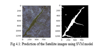
The SVM model attained 69.72% accuracy and a precision of 0.7846 on the test set. In the confusion matrix, it correctly classified 1,052 water pixels and 857 non-water pixels. However, it misclassified 291 water pixels as non-water and 532 non-water pixels as water.
Conclusion
This approach outperforms others by utilizing supervised algorithms like SVM to effectively learn and classify shadow features. It integrates shadow detection masks to precisely distinguish objects such as glass from shadows, facilitating the removal of shadows from satellite images. By computing the disparity between input and shadow-free images, this method guarantees improved image clarity. These enhancements are vital for landscape recognition, providing a clearer view for landscape analysis and offering valuable insights with widespread applications.
References
[1] Mikic, A.Prati, M.Trivedi, R.Cucchiara. Detecting moving Shadows: Algorithms and Evaluation, IEEE Transactions on Pattern Analysis and Machine Intelligence.Vol.25, Iss.7.2017. [2] Ratnadeep Roy,Archek Praveen Kumar, Ashwani Kumar Yadhev, Cheruku Sandesh kumar. Segmentation on moving Shadow Detection and Removal by Symlet Transform for Vehicle Detection. Third Int. Conf on Comp. for Sust. Global Devel., IEEE,2016. [3] V. Kushwaha, D. Gupta, P. K. Singh and A. Gupta, \"Deep Learning based Detection of Water Bodies using Satellite Images,\" 2021 International Conference on Intelligent Technologies (CONIT), Hubli, India, 2021, pp. 1-4, doi: 10.1109/CONIT51480.2021.9498442. [4] Clement Fredembach, Domininc Rufenacht, Sabine Susstrunk.Automatic and Accurate Shadow Detection Using Near Infrared Information. IEEE Transactions on Pattern Analysis [5] Gharbia, R. Deep Learning for Automatic Extraction of Water Bodies Using Satellite Imagery. J Indian Soc Remote Sens 51, 1511–1521 (2023). https://doi.org/10.1007/s12524-023-01705-0 [6] V. M. Manikandan,K. Jagruth and R. K. Kumar, \"Water Body Identification from the Satellite Images using Color Component Analysis with Morphological Operations,\" 2021 12th International Conference on Computing Communication and Networking Technologies (ICCCNT), Kharagpur, India, 2021, pp. 01-07, doi: 10.1109/ICCCNT51525.2021.9579839. [7] D. Sai Siva Teja , D. L Rama Charan, R. Subhashini and G. Meera Gandhi,” Convolutional Neural Network based Water Resource Monitoring Using Satellite Images”, Proceedings of the Fifth International Conference on Communication and Electronics Systems (ICCES 2020) IEEE Conference Record # 48766; IEEE Xplore ISBN:978-1-7281-5371-1 [8] A NEW WATER DETECTION FOR MULTISPECTRAL IMAGES BASED ON DATA SIMULATION AND RANDOM FOREST, IGARSS 2022 - 2022 IEEE International Geoscience and Remote Sensing Symposium [9] Support Vector Machine based Remote Sensing using Satellite Data Image, Proceedings of the Second International Conference on Smart Electronics and Communication (ICOSEC). IEEE Xplore Part Number: CFP21V90-ART; ISBN: 978-1-6654-3368-6
Copyright
Copyright © 2024 Dr. Rajkumar L. Biradar, Akhila Mucharla, Sowmya Thatipalli, Sathvika Adepu, Pujitha Mandava. This is an open access article distributed under the Creative Commons Attribution License, which permits unrestricted use, distribution, and reproduction in any medium, provided the original work is properly cited.

Download Paper
Paper Id : IJRASET61706
Publish Date : 2024-05-06
ISSN : 2321-9653
Publisher Name : IJRASET
DOI Link : Click Here
 Submit Paper Online

