Ijraset Journal For Research in Applied Science and Engineering Technology
- Home / Ijraset
- On This Page
- Abstract
- Introduction
- Conclusion
- References
- Copyright
Developing a Scalable Public Bus Tracking System with IOT Technology
Authors: Pallam Venkatapathi, Maripeddi Vaishnavi, Kouru Kumar Ram, Vodamalla Nuthan Kumar, Haripal Reddy Kota
DOI Link: https://doi.org/10.22214/ijraset.2024.65141
Certificate: View Certificate
Abstract
Due to erratic schedules, millions of commuters lose important time waiting for public transportation. This study suggests a method based on the Internet of Things (IoT) to improve the dependability of public transit. Our method gives precise anticipated arrival times at bus stops and destinations by utilizing road conditions and real-time bus location data. Our approach provides an economical and effective substitute for conventional GPS-based tracking systems by utilizing the internet-enabled devices that are already on buses and a scalable Message Queue Telemetry Transport (MQTT) backend. Simple access to location data is made possible by an intuitive web interface, SMS, and Android application. By addressing the scalability issues with current solutions, our method guarantees a stable and dependable public transit experience.
Introduction
I. INTRODUCTION
`One of the biggest problems facing cities today is transportation. Increasing the efficiency of public transportation networks is imperative due to their constantly growing load. Public buses are late and unreliable because of heavy traffic, crowding, and numerous other related problems. This problem needs to be addressed immediately. In addition to facilitating service enhancement, the necessary answer need to be a catalyst for a rise in public bus transportation systems' credibility.
When passengers are aware of the exact time a bus will arrive at the bus stop or arrive at their destination, public transportation will be more reliable. The method put forward in this paper leverages the buses' real-time locations to estimate how long it will take to get to a specific destination. We can use services like Google Maps to estimate the time it will take for a bus to arrive at a bus stop or to reach a destination by storing location data and associated timestamps on the server.
In order to make public transportation services "smart," this article offers an easy and affordable option. The concept, technological stack, elements, and results of the solution's implementation will all be covered in the paper. Reducing deployment costs and developing a backend that can readily grow with demand are the main objectives of the suggested solution. Both consumers and developers should have access to the location data gathered from the buses so they can utilize it to generate additional value.
II. LITERATUREREVIEW
As part of the suggested system, an Android application is created to track the location of the bus and keep student information. Students can use this application to find the bus's location and receive notifications in the event that the bus number changes. The available notifications and the bus location on the Google Map are visible to the student upon logging into this application. Furthermore, the specific person waiting to board the bus is notified right away if there is a change in the bus route and there are people waiting at the bus stop. So that, the particular person can takes necessary actions to reach their destination without any time delay.
The web server utilize the technology of Location-Based Services: These services use client-server technology to track the bus's present location and estimate any deviations in the bus route. The web server receives the current position from each bus. This data is kept in the server database. Using the Kalman filter algorithm, students who installed the college bus tracking app can monitor the bus's routes, number, location, and arrival time. The pupils' waiting time is decreased since the bus location is tracked using a global positioning system and displayed on a Google map.[1] offers an Android smart phone app that provides online and offline bus information, including bus numbers and itineraries.
The rationale for the Android platform Android needs open source development, which is currently the most practical and user-friendly strategy. Additionally covered in this article are location-based services, which are used to track the bus's present location and provide an Using client-server technology, determine how long it will take the tracked bus to arrive at its destination. Additionally, It uses GPS to display the necessary maps.
Two Android applications were created: one that allows the driver to begin uploading the bus's location to the server, and another that allows the user to view the bus's location on a Google Map and retrieve the bus's location as well as the time it takes to get to a specific stop. For the administrator to oversee the bus routes and the stops they serve, we have also created a web interface.[2]
III. COMPONENTS
A. Arduino
Arduino is an open-source electronics platform based on easy-to-use hardware and software. Arduino boards are ableto read inputs - light on a sensor, a finger on a button, or a Twitter message - and turn it into an output - activating amotor, turning on an LED, publishing something online. You can tell your board what to do by sending a set ofinstructionstothemicrocontrolleron the board.
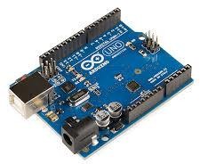
Fig1.Internet ofThings
B. LCD
A liquid crystal display(LCD) is a thin, flat display device made up of any number of color or monochrome pixels arrayed in front of a lights ource or reflector. Each pixel consists of a column of liquid crystal
molecules suspended between two transparent electrodes, and two polarizing filters, the axes of polarity ofwhich are perpendicular to each other. Without the liquid crystals between them, light passing through one would be blocked by the other. The liquid crystal twists the polarization of light entering one filter to allow it to pass through theother
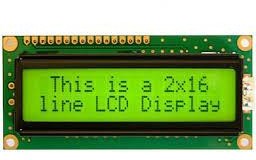
Fig2.LCD
C. GPS
GPS (Global Positioning System) is a network of satellites orbiting Earth that provide location information to GPSreceiverson the ground.
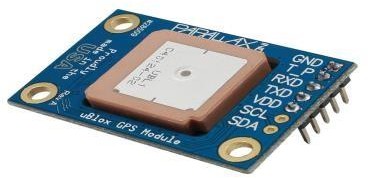
Fig3.GPS
D. IR Sensor
IR sensor is an electronic device, that emits the light in order to sense some object of the surroundings. An IR sensor can measure the heat of an object as well as detects the motion. Usually, in the infrared spectrum, all the objects radiatesome form of thermal radiation. These types of radiations are invisible to our eyes, but infrared sensor can detect theseradiations.
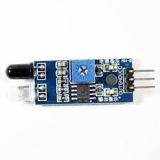
Fig4.IRSensor
E. Buzzer
A buzzer or beeper is an audio signaling device, which may be mechanical, electro mechanical.
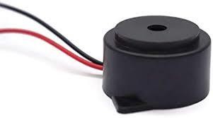
Fig5. BusTracking
IV. WORKING
With the use of an inventive real-time tracking system that makes use of the Internet of Things, this article aims to revolutionize the dependability and effectiveness of urban bus transit. Through the use of internet-enabled devices, like Android tablets that are already installed on buses or e-ticketing systems, the system gathers exact position data without the need for extra hardware, which makes it both affordable and easily integrated. The Message Queue Telemetry Transport (MQTT) protocol, which is the foundation of this solution, is a lightweight but effective technology that permits continuous and effective data transfer while significantly reducing bandwidth and resource usage in comparison to conventional HTTP-based systems.
This effectiveness guarantees that the system can manage high user request quantities, which is essential in busy metropolitan environments. After being recorded, the real-time location data enters an advanced distributed server infrastructure designed to handle and process large volumes of traffic. The data burden is divided among servers by this backend, which is organized with scalable database storage and controlled by load balancers. When combined, these elements let users access data quickly and smoothly, especially during busy times, and guard against system faults or slowdowns. Users can instantaneously get this real-time bus position information via a web site, SMS, or mobile application. In addition to providing easy access, REST APIs act as a link between the user interfaces and the backend, allowing third-party developers to use the data for new tools and apps like personalized arrival announcements and sophisticated route analytics. The system also uses historical data-based prediction algorithms to deliver accurate bus arrival forecasts, improving accuracy by taking into account past trends and current traffic conditions. These prediction algorithms give customers accurate arrival time estimates and assist them in better route planning by combining past trends with current GPS data.
In conclusion, this Internet of Things-powered bus tracking system is a reliable, expandable, and user-focused approach to real-time public transportation monitoring. While preserving network resources, the MQTT protocol offers the scalability and stability required to manage increasing user demand. The end product is a reliable and reasonably priced tracking system that can adapt to the changing requirements of urban public transit.
V. BLOCKDIAGRAM
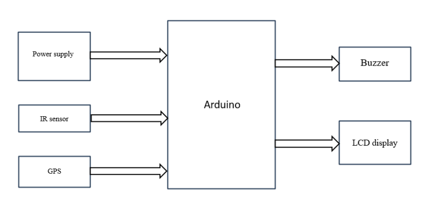
Fig6.Block Diagram
Typically, bus tracking systems show data related to the arriving buses, time to arrival and estimated departure time based on location of bus that is obtained via Radio Frequency (RF) transceiver. There are such transceivers on every bus and bus stops so that the buses communicate the location to bus stops. The microprocessors at bus stop then calculate estimated time for arrival and display it on a screen. SMS services on GSM are used in some solutions as means for communication. There are GSM modules with Global Positioning System (GPS) on the bus. These periodically send the location to databases through SMS. The location data can then be accessed by sending SMS to receivers on the database servers. Location data can be obtained by GPS based tracking devices mounted on vehicles. These systems use Hyper Text Transfer Protocol (HTTP) to send location data to databases. Android devices in the buses stream location data to servers, which can be accessed through android applications or web-portals.
VI. OPERATIVEBENEFITS
- Real-time tracking: Monitor bus locations and schedules.
- Reduce wait times and increase reliability.
- Route optimization: Improve journey times and reduce fuel consumption.
- Automated scheduling: Adjust schedules based on traffic and passenger demand.
- Vehicle performance monitoring: Track fuel efficiency, speed, and maintenance needs.
- Safety and Security.
- Cost Savings.
VII. RESULT
By giving users access to real-time bus locations and predicted arrival times, the proposed system improves the efficiency of public transportation by enabling more precise journey planning. The public bus service becomes more dependable with this access to real-time data, which helps cut down on wait times at bus stops. This service is available to users through an Android application, SMS, or website that shows bus location information depending on the destination bus stop or route number. Users' convenience is further increased by the application's automatic selection of the closest bus stop as the boarding location, as seen in the screenshots supplied.
The Erlang-based MQTT broker (eMQTTD), which powers this system's backbone, is renowned for its scalability and capacity to manage up to 1.3 million concurrent connections per node. By adding more brokers to the cluster, the system may readily grow as the user base increases. To sustain high performance, the clustered nodes efficiently distribute the load by acting as a single MQTT broker. In order to ensure that the system is both scalable and resilient enough to manage growing server loads, eMQTTD additionally connects with MongoDB for data storage. A strong basis for the expansion of public transportation systems in the future is provided by this combination of real-time tracking, scalability, and economical backend architecture.

Fig7.Result
Conclusion
By utilizing MQTT instead of conventional HTTP, the suggested solution offers a cutting-edge and effective method for tracking public buses. Because of its great scalability and readiness for the future, this design can easily expand horizontally to meet growing demand. The system is more data-efficient and lightweight in terms of data transfer thanks to the use of MQTT, which guarantees low bandwidth usage and permits on-demand access to real-time bus location data. The system\'s scalability is improved by the distributed backend, which is made to handle increasing user traffic and provide stable performance even under heavy loads. In the end, this approach offers a creative, economical, and sustainable foundation for the future of smart transit and is a major step towards enhancing the dependability and effectiveness of public transportation networks.
References
[1] P. Suganya and T. Karthija, Effective Tracking of Bus Location Using Map Matching Algorithm American-Eurasian Journal of Scientific Research 12 (5): 229- 235, 2017 ISSN 1818-6785 IDOSI Publications, 2017 DOI: 10.5829/idosi.aejsr.2017.229.235 [2] Ajay R, Monisha M V, Fire Engine Automated Rescue System IOSR Journal of Elec- trical and Electronics Engineering (IOSR-JEEE) e-ISSN: 2278- 1676,pISSN: 2320-3331,Volume 11, Issue 4 Ver. III (Jul. Aug. 2016), PP 16-22www.iosrjournals.org. [3] System”, in “International Journal of Soft Computing and Engineering (IJSCE)”, ISSN:2231-2307, Volume-1,Issue-6,January201234 [4] MaruthiR.,JayakumariC.,“SMS based Bus Tracking System using Open Source Technologies”,inInternational Journal of Computer Applications(0975–8887)“,Volume 86– No9, January2014 [5] Salim A., Idrees Ibrahim , “Design and Implementation of Web-Based GPS-GPRS Vehicle Tracking System”, inInternational Journal of ComputerScience and InformationTechnologies,Vol3,Issue12,443-448,Dec 2013. [6] Tejaswi, P., and P. Venkatapathi. \"IOT based smart home with load control.\" International Journal for Research in Applied Science & Engineering Technology 8 (2020): 876-881. [7] Vasileios Karagiannis, Periklis Chatzimisios, Francisco Vazquez-Gallego and Jesus Alonso-Zarate, “A Survey on Application Layer Protocols for the Internet of Things”,TransactiononIoTandCloudcomputing,2015 [8] Z.Wei,Y.Song,H.Liu,Y.ShengandX.Wang,\"The research and implementation of GPS intelligent transmission strategy basedonon-board Android smart phones, \"Computer Scienceand Network Technology(ICCSNT), 2013 3rd International Conferenceon, Dalian,2013, pp.1230-1233 [9] Y.ChenandT.Kunz,\"Performance evaluation of IoT protocols under acons trained wireless saccess network,\"2016 International Conference on Selected Topics in Mobile & Wireless Networking (MoWNeT), Cairo, 2016,pp.1-7 [10] Santosh, M., and Venkatapathi Pallam. \"Vehicle Position of Self-Recognition using Ultra High Frequency Passive RFID Tags.\" International Journal of Scientific Engineering and Technology Research 3, no. 32 (2014): 6294-6300. [11] K.TanakaandK.Naito,\"Demo: Implementation of unconscious bus locations ensing system with smart phone devices and beacon devices,\" 2016 13th IEEE Annual Consumer Communications & Networking Conference(CCNC),LasVegas, NV,2016, pp.280-281. [12] Ahmed N.Abdalla, Azher Fakharuddin, Muhammad Rauf and NikM.Kamal ,“Design of Intelligent GPS Navigation System for Bus Monitoring and Station Reporting”,National Conference on Postgraduate Research, 2009. [13] J. Gong, M. Liu and S. Zhang, \"Hybrid dynamic prediction model of bus arrival time based on weighted ofhistoricalandreal-timeGPSdata,\"201325thChineseControlandDecisionConference(CCDC), Guiyang,2013,pp. 972-976 [14] Francis, Angelica Pearl, P. Venkatapathi, JL Divya Shivani, and M. Sreedhar Reddy. \"Embedded System Application on Shipping Surveillance and Control.\" [15] L. Singla and P. Bhatia, \"GPS based bus tracking system,\" Computer, Communication and Control (IC4), 2015InternationalConferenceon, Indore,2015,pp.1-6. [16] Venkatapathi, Pallam, Kondu Vinay, Kummathi Harshavardhan Reddy, Mulli Karthik, and Sudhakar Alluri. \"Real Time Driver Gaze Tracking and Eyes off the Road Detection System.\" [17] Googlemaps,https://developers.google.com/maps/ [18] ChhedaGaurav,GajraNiket,ChhayaManal,DeshpandeJitesh,GhargeSaylee,“Real Time Bus monitoring and Passenger Information [19] Sudhakar Alluri Pallam Venkatapathi , Kondu Vinay , Kummathi Harshavardhan Reddy, Mulli Karthik. \" Traffic Signal Controller System and Vehicle Count-Based Road Congestion Detection\" International Journal for Research in Applied Science & Engineering Technology, Volume 12, Issue 4, Pages 183-187, 2024. [20] Haripal Reddy Kota, Barre Nikhitha, Karedla Akshitha, Pudota Praveen Naidu, Pallam Venkatapathi. \"IOT E-Circular Notification for Students Using a WIFI-Based LED Advertising Board\" International Journal for Research in Applied Science & Engineering Technology, Volume 11, Issue XI, Pages 1080-1084, 2023.
Copyright
Copyright © 2024 Pallam Venkatapathi, Maripeddi Vaishnavi, Kouru Kumar Ram, Vodamalla Nuthan Kumar, Haripal Reddy Kota. This is an open access article distributed under the Creative Commons Attribution License, which permits unrestricted use, distribution, and reproduction in any medium, provided the original work is properly cited.

Download Paper
Paper Id : IJRASET65141
Publish Date : 2024-11-11
ISSN : 2321-9653
Publisher Name : IJRASET
DOI Link : Click Here
 Submit Paper Online

