Ijraset Journal For Research in Applied Science and Engineering Technology
- Home / Ijraset
- On This Page
- Abstract
- Introduction
- Conclusion
- References
- Copyright
FLOODGUARD: An IoT-Powered Real-Time Flash Flood Monitoring and Forecasting System"
Authors: Mr. P. Venkanna, D. Prasannakumar, V. Aravind, K. Raviteja, P. Seshanjaneyulu
DOI Link: https://doi.org/10.22214/ijraset.2024.60174
Certificate: View Certificate
Abstract
In recent times, the surge in flooding incidents has become a pressing global issue, inflicting extensive damage on both lives and livelihoods. While floods remain an inevitable force of nature, their devastating impact can be alleviated. With the aid of cutting-edge technologies like the Internet of Things (IoT), proactive flood forecasting has become increasingly feasible. Through the seamless integration of IoT data, populations can receive early warnings and evacuate to safety, safeguarding both lives and valuables. A real-time solution is imperative, leveraging IoT data streams to deliver timely flood alerts. Our study presents an IoT-driven prototype designed to collect hydrological data from rivers, encompassing metrics such as water flow, level, and discharge, alongside meteorological parameters like temperature, humidity, wind speed, and direction. Employing a Long Short-Term Memory (LSTM) model, we analyze and classify collected data based on water discharge, level, rainfall, and temperature, predicting flood events as \"no alert,\" \"yellow alert,\" \"orange alert,\" or \"red alert.\" Given the dynamic nature of rivers, accurately measuring total water discharge poses challenges. To address this, we propose a novel methodology utilizing water flow, sectional area width, and average depth. Furthermore, we tackle the complexities associated with accurately measuring rainfall due to erratic weather conditions. Our system demonstrates robust performance in predicting flood event states, achieving high F1-scores of 97% for \"no alert,\" 97% for \"yellow alert,\" 96% for \"orange alert,\" and 98% for \"red alert.\"
Introduction
I. INTRODUCTION
In everyday language, when human lives are at risk due to any naturally occurring event, that situation is commonly referred to as a natural calamity. Nature's fury, including thunderstorms, cyclones, tornadoes, floods, flash floods, droughts, seismic events, landslides, and avalanches, wreak havoc, causing harm to property and inflicting human casualties, as well as economic setbacks [1]. Roads sustain severe damage, large structures crumble, bridges fail, vehicular mishaps abound, and comparable devastations occur as a result of these catastrophic events. It poses a formidable challenge... for governmental and administrative bodies to bounce back from the damages incurred by the calamities. Inundation emerges as a foremost challenge [2] experienced in diverse locations worldwide. A flood arises when there is an excessive rise in water levels, such as when snow melts excessively [3].While these calamities cannot be eradicated, the profound damage they cause can be mitigated. Disaster mitigation, encompassing both structural and nonstructural measures, is imperative to safeguard human lives and assets from natural calamities. It includes a thorough assessment of the damage caused by disasters, restoration of communication channels, transportation and rescue, water intake, and restoration of electric power to the affected areas [1]. One of the pivotal strategies within the realm of nonstructural approaches to disaster mitigation is to alert the populace prior to the onset of the calamity. Accordingly, plans for rescue operations are also formulated.
The state of Uttarakhand, situated in northern India, has not been spared from the impact of natural calamities. This Himalayan region, with its distinct geological characteristics, has experienced formations, environmental conditions, and climatic fluctuations, is frequently susceptible to natural calamities, notably floods, landslides, and earthquakes. In 2013, inundations in Kedarnath, Uttarakhand, resulted in catastrophic devastation, claiming the lives of over 6000 individuals Flood disasters have had a very adverse effect on the life of the people of Uttarakhand in the last few decades [3]. Moderate or torrential rains from mid-June to September. (i.e., monsoon) come as a problem for the people here. The livelihoods of individuals in this mountainous region are severely disrupted by floods, resulting in loss of life and property. Agricultural land, as well as public infrastructure including roads, bridges, and educational facilities, suffer damage The damage caused by floods can be mitigated through the implementation of appropriate measures.
It is essential to identify the flood-prone areas., so that proper arrangements can be made.Whether it is flood prediction or early warning systems based on thresholds in India ,This achievement would not have been attainable without the contributions of the India Meteorological Department (IMD) and the Central Water Commission (CWC). The IMD offers meteorological or weather forecasts, while the CWC furnishes flood predictions at multiple river sites. Consequently, the efficacy of flood prediction systems hinges on the timeliness of weather forecasts provided by the IMD and how quickly. The majority of flood forecasts in India is based on old statistical techniques that have a lead time of less than 24h. Between the base station and the forecast station, these statistical techniques fail to receive the hydrological data of the river basins.
A. Our Contribution
Floods result in losses to human lives, property, and the environment. Therefore, there is a need for assessing of floods with regards to sustainable development. The achievements of the present study are delineated as follows.
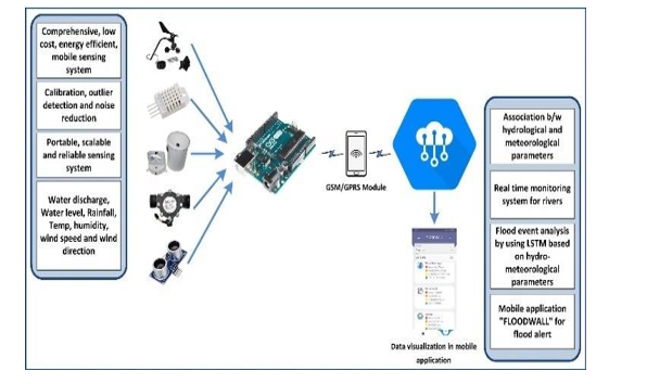
A holistic, cost-effective, energy-conserving, portable sensing system is proposed, delivering instantaneous and continuous information. Calculating the overall water discharge poses challenges due to the dynamic geographic characteristics of the rivers. To address this challenge, an innovative approach for computing water discharge based on water flow, sectional area width and sectional average depth is proposed .Sudden and swift alterations in the sensor's operational surroundings impact the sensor output values. Consequently, the projected output deviates from the actual output. Sensor calibration facilitates enhancing sensor precision and performance.
Calibration and anomaly detection techniques have been utilized to minimize prediction discrepancies For the creation of a real-time flood prediction system, simultaneous availability of hydrological and meteorological data is essential. The proposed system offers a distinctive aspect in its method for establishing correlation.
Between hydrological and meteorological parameters to predict the flash flood. Given the dynamic geographic attributes of rivers in hilly regions, the present study has been conducted to investigate the portability, scalability, and reliability of the sensing system to collect the data. A forecast model is built using long short-term memory (LSTM) technique, and its performance is thoroughly assessed using metrics such as root mean square error (RMSE) and precision, recall, and F1-score, which has been further compared with existing systems in the literature to validate the model.
II. RELATED WORK
The domains of application for the Internet of Things (IoT), sensing, analysis, and modeling of flash flood have been discussed in some of the recent works.Hart and Martinez [7] explored how IoT can transform a conventional wireless sensor network (WSN) to connect the world of things, which can provide seamless connections to connect the world of things, which can provide seamless connections, water quality, radiation pollution, and agriculture systems. Sandro et al. [9] present an efficient digitization process for improvements and effective use of limited resources, process, and system by using IoT-supportedsmart technologies. Minghu and Li [10] proposed a low-cost and high-speed data collection system across hard-to-reach areas by using IoT-enabled drone, based on 5 GHz and long range (LoRa) technology. To tackle challenges such as cost, time consumption, and power consumption associated with air quality monitoring stations, Jalpa and Mishra [11] suggested the IoT-integrated environmental monitoring system. In [12], a river flood surveillance, modeling, and forecasting methodology by scrutinizing the physical processes of the river.. Shi-Wei et al. [13] proposed an image-based monitoring system for flood occurrence and analysis of water-level changes. They have used a camera for visual sensing of river water level. Mustafa et al. [14] (PIR) sensors that can continuouslymonitor water level and remote temperature, respectively. A combination of artificial neural network (ANN) and L1- regularized reconstruction are used to process measurement data. Prachatos et al. [15] proposed a model to collect the data by using WSN network, which has been implemented by using a modified mesh network over ZigBee, and to send the data over the Internet, a general packet radio service (GPRS) module is used. Gustavo et al. [16] have developed a fault- tolerant embedded system to detect and forecast the occurrence of flood based on WSN, IoT, and machine learning (ML) named as SENDI and evaluated on ns- 3.
Jayashree et al. [17] explored various flood forecasting methodologies and introduced a flood warning system, addressing the limitations identified in the reviewed systems. Kun et al. [18] conducted flood detection through IoT and dispatched alert messages to end users, containing information on water level conditions and flow over time. Shah et al. [19] devised a flood alert mechanism capable of measuring river water levels and the rate of increase, enabling early notifications via short message service (SMS). Abdullahi et al. [20] integrated. flow sensor, water-level sensor, and pressure gauge to gather data and assess flood conditions using a two-class neural network on Microsoft’s AzureML. Qundus et al. [21] introduced a flood detection system to collect data such as precipitation, temperature, humidity, water level, wind speed, and air pressure from sensors, monitoring variations in weather conditions compared to historical data. Kumar et al. [22] engineered an IoT system to collect rainfall and water level data, employing an expert system to analyze data for flood risk assessment. Mendoza-Cano et al. [23] developed an IoT-based flood monitoring system for hydrometeorological data, including weather parameters, soil moisture, and water level. Kitagami et al. [24] proposed a resilient network based on an event- driven data collection mechanism and feedback control system for real-time flood alerts. Sunkpho and Ootamakorn [25] established real-time water condition monitoring using WSN, employing mobile GPRS communication to transmit measured data to the server. Ghapar et al. [26] suggested an IoT system for flood data management, facilitating IoT infrastructure development for collecting, transmitting, and managing flood data. Dragulinescu et al. [27] proposed a smart IoT platform to monitor neighborhoods, issuing alerts to residents and responding to emergencies in their building or nearby structures. Basnyat et al. [28] outlined a design approach and detailed architecture for three distinct types of IoT- based flash flood detection systems.
A. Research Gaps
Existing studies have not sufficiently explored the monitoring and analysis of hydrological and meteorological parameters. There is a lack of research on identifying the most suitable, cost-effective, and energy- efficient sensors, microcontroller boards, communication modules, and cloud architectures for constructing a prototype to sense and analyze environmental parameters. While flood monitoring facilities are abundant in urban areas, there is a dearth of such facilities for populations residing in adjacent areas, along riverbanks, and in hilly regions. Limited attention has been given to calibration, outlier detection, and noise reduction methods for preprocessing sensed data. Research has yet to investigate the portability, scalability, and reliability of sensing devices. Hence, the impetus behind developing a comprehensive, cost-effective, energy-efficient, mobile sensing system based on IoT technology to monitor and forecast flash flood events and related parameters
III. ARCHITECTURE OF THE PROPOSED IOT SYSTEM
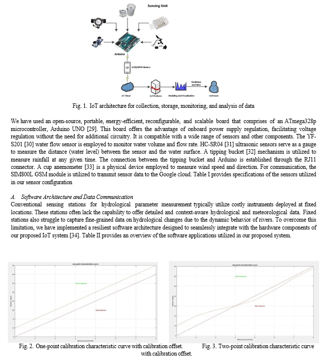
To oversee and report flood-like scenarios, there's a necessity for a system that endures extended periods and remains operational in remote regions with limited resources. To tackle these challenges, the proposed IoT architecture, illustrated in Fig. 1, incorporates a variety of inexpensive and energy- efficient sensors linked to a microcontroller. These sensors transmit collected data to the IoT cloud, where it undergoes further analysis, and users can access the information via an Android application.
This system actively monitors, gathers, stores, analyzes, and presents data in real-time. Hydrometeorological data are stored and and analyzed in the IoT cloud.
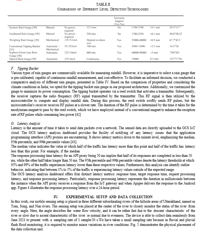
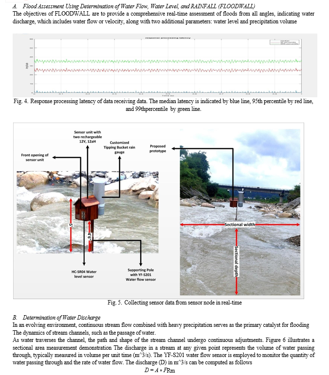

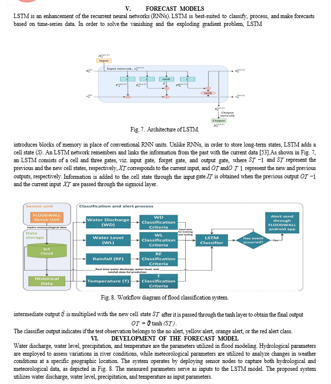
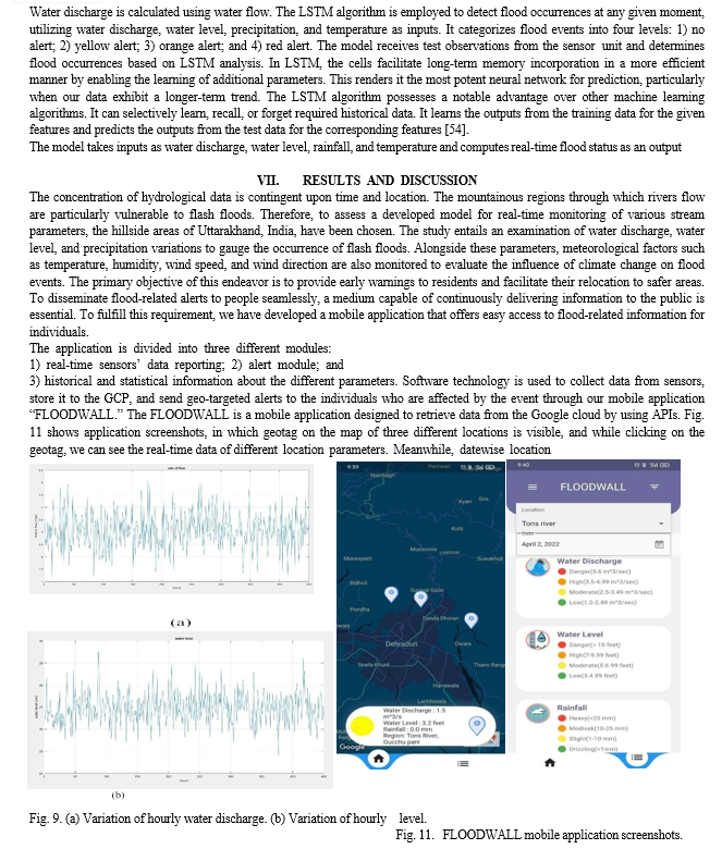
specific information of different parameters is also available in the application. The application receives the updated data after every 5 min from the cloud. It shows the most recent hydrological and meteorological data, such as water discharge, water level, rainfall, temperature, humidity, wind speed, and wind direction. The application is able to show the data of three different rivers as per the user’s choice and selected date.
Since the sensors are already calibrated, the data coming from these sensors are accurate and correct. Furthermore, the alert module gives an alert to the user of the application and local authorities, when the values coming from the sensors exceed the predefined threshold values, configured in the system, through notifications.
The third module of the application is used for showing the historical and statistical information about the different parameters of the rivers in the form of graphs and charts. Fig. 9(a) and (b) shows the variation of hourly water discharge (calculated by taking sectional area of stream and water flow) and water level from September 15, 2021 to September 25, 2021 The data used for training and testing of the prediction model including the parameters, such as water discharge, waterlevel, and rainfall, are based on a database that was built using the FLOODWALL device. Total 5919 experimental observations.
A. Area Under ROC
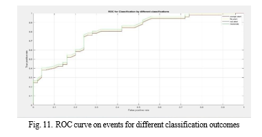
An ROC curve displays the sensitivity (TP rate) as a functionof (1 specificit−y) or the false alert ratio for various parameter threshold values. The ROC curve points provide a sensitivity pair for a certain decision threshold. The area underthe curve (AUC) is a metric that measures a parameter’s ability to differentiate between different types of predicted classes.
shows the classification performance of the flood alert in the proposed model. The mean accuracy, precision, recall, and F1 scores for the red alert event are 99%, 98%, and 98%, respectively. The measures for orange alert incidents are 97%, 95%, and 96%, respectively. They are 97, 97, and 97, respectively, for the mild alert events. No threat event produces the best outcomes, with a TP rate of 99%, followed by moderate threat, threat with danger incidence, and high threat. The current model is quite accurate, with a mean F1 score of 0.97 for the four classes of the alert. The proposed model’s classification accuracy is illustrated clearly in Fig. 10 with the help of the ROC curve.
According to the flood alert ROC curve, the high alert event covers the most area, followed by the moderate alert, danger alert, and no alert events. The notifications are delivered to the user in the form of application alerts. The user receives notifications on their smartphone screen via the FLOODWALL Android application, which they need to install.
B. Model Validation
Several studies have reported the development of hardware and software solutions for analysis and detection of flash flood events; however, they are of limited use in establishing a comprehensive solution for flood disaster detection. This might be due to the coverage and integration of various geographies, climates, and data. Validation through comparison with another system is challenging; however, it may be possible by making use of different performance parameters of classification. To validate the prediction model’seffectiveness, three measures for classification performance (RMSE, correlation, and F1-score) have been used. Table VI shows the model validation through performance comparison with the existing systems. The developed classifier obtained anF1-score of 97% for “no alert,” 97% for “yellow alert,” 96% for “orange alert,” and 98% for “red alert,” which is clearlyan improved prediction technique over other systems.
Conclusion
The research work carried out the development of a real- time monitoring system for rivers of the hillside area of Uttarakhand, India, to show the most recent hydrological and meteorological data, such as water discharge, water level, rainfall, temperature, humidity, wind speed, and wind direction. Furthermore, on the basis of the data received, the system generates an alert to the users and local authorities when the values coming from the sensors are predicted the status of the flood event by using LSTM model, through SMS and notifications. The proposed system is able to show historical and statistical information about different parameters of the rivers in the form of graphs and charts. Our low-cost and energy-efficient flood inundation IoT sensor unit is working on a sensor technology that monitors three remote flood-prone areas in real-time, where network availability is not so good. We have designed a mobile application “FLOODWALL” to retrieve data from the Google cloud by using APIs, which shows the most recent hydrological and meteorological data and generates an alert when the values coming from the sensors exceed the predefined threshold values, configuredin the system through SMS and notifications. Our proposed system is successfully able to monitor regional pluvial and fluvial flood- related parameters since July 2021 and provide real-time flood- related information with 1 sample/30 s from three different remote locations. The sensors that we have used in our system are calibrated in advance and the data coming from these sensors are very much accurate and correct. The system works efficiently in terms of real-time data collection and end-user alerting. However, to increase the accuracy of flood forecasting, the proposed system can be integrated with geographic information systems and remote sensing technologies in future.
References
[1] L. Zhou, X. Wu, Z. Xu, and H. Fujita, “Emergency decision making for natural disasters: An overview,” Int. J. Disaster Risk Reduction, vol. 27,pp. 567–576, Mar. 2018 [2] M. P. Mohanty, S. Mudgil, and S. Karmakar, “Flood management in India: A focussed review on the current status and future challenges,” Int. J. Disaster Risk Reduction, vol. 49, Oct. 2020, Art. no. 101660. [3] S. Bisht, S. Chaudhry, S. Sharma, and S. Soni, “Assessment of flash flood vulnerability zonation through Geospatial technique in high altitude Himalayan watershed, Himachal Pradesh India,” Remote Sens. Appl., Soc. Environ., vol. 12, pp. 35–47, Nov. 2018. [4] A. Khanna and S. Kaur, “Internet of Things (IoT), applications and challenges: A comprehensive review,” Wireless Pers. Commun., vol. 114, no. 2, pp. 1687–1762, Sep. 2020. [5] Uttarakhand Disaster 2013. Accessed: Aug. 10, 2022. [Online].Available: https://nidm.gov.in/pdf/pubs/ukd-p1.pdf [6] M. Ishiwatari, T. Koike, K. Hiroki, T. Toda, and T. Katsube, “Managing disasters amid COVID-19 pandemic: Approaches of response to flood disasters,” Prog. Disaster Sci., vol. 6, Apr. 2020, Art. no. 100096. [7] J. K. Hart and K. Martinez, “Toward an environmental Internet of Things,” Earth Space Sci., vol. 2, no. 5, pp. 194–200, May 2015. S. L. Ullo and G. R. Sinha, “Advances in smart environment monitoring systems using IoT and sensors,” Sensors, vol. 20, no. 11, p. 3113, May 2020 [8] S. Nižetic´, P. Šolic´, D. López-de-Ipiña González-de-Artaza, andL. Patrono, “Internet of Things (IoT): Opportunities, issues and challenges towards a smart and sustainable future,” J. Cleaner Prod., vol. 274, Nov. 2020, Art. no. 122877 [9] M. Zhang and X. Li, “Drone-enabled Internet-of-Things relay for environmental monitoring in remote areas without public networks,” IEEE Internet Things J., vol. 7, no. 8, pp. 7648–7662, Aug. 2020 [10] J. Shah and B. Mishra, “IoT-enabled low power environment monitoring system for prediction of PM2.5,” Pervas. Mobile Comput., vol. 67, Sep. 2020, Art. no. 101175 [11] G. Merkuryeva, Y. Merkuryev, B. V. Sokolov, S. Potryasaev,V. A. Zelentsov, and A. Lektauers, “Advanced river flood monitoring, modelling and forecasting,” J. Comput. Sci., vol. 10, pp. 77–85, Sep. 2015 [12] S.-W. Lo, J.-H. Wu, F.-P. Lin, and C.-H. Hsu, “Visual sensing for urban flood monitoring,” Sensors, vol. 15, no. 8, pp. 20006–20029, Aug. 2015. [13] M. Mousa, X. Zhang, and C. Claudel, “Flash flood detection in urban cities using ultrasonic and infrared sensors,” IEEE Sensors J., vol. 16, no. 19, pp. 7204–7216, Oct. 2016. [14] P. Mitra et al., “Flood forecasting using Internet of Things and artificial neural networks,” in Proc. IEEE 7th Annu. Inf. Technol., Electron. Mobile Commun. Conf. (IEMCON), 2016, pp. 1–5. [15] G. Furquim, G. Filho, R. Jalali, G. Pessin, R. Pazzi, and J. Ueyama, “How to improve fault tolerance in disaster predictions: A case study about flash floods using IoT, ML and real data,” Sensors, vol. 18, no. 3, p. 907, Mar. 2018. [16] S. Jayashree, S. Sarika, A. L. Solai, and S. Prathibha, “A novel approach for early flood warning using Android and IoT,” in Proc. 2nd Int. Conf. Comput. Commun. Technol. (ICCCT), Feb. 2017, pp. 339–343. [17] K. Han, D. Zhang, J. Bo, and Z. Zhang, “Hydrological monitoring system design and implementation based on IoT,” Phys. Proc., vol. 33, pp449– 454, Dec. 2012. [18] W. M. Shah, F. Arif, A. A. Shahrin, and A. Hassan, “The implementation of an IoT-based flood alert system,” Int. J. Adv. Comput. Sci. Appl., vol. 9, no. 11, pp. 620–623, 2018. [19] S. I. Abdullahi, M. H. Habaebi, and N. A. Malik, “Intelligent flood disaster warning on the fly: Developing IoT-based management platform and using 2-class neural network to predict flood status,” Bull. Electr. Eng. Informat., vol. 8, no. 2, pp. 706–717, Jun. 2019. [20] J. Al Qundus, K. Dabbour, S. Gupta, R. Meissonier, and A. Paschke, “Wireless sensor network for AI-based flood disaster detection,” Ann. Oper. Res., pp. 1–23, Aug. 2020. [21] C. K. Khuen and A. Zourmand, “Fuzzy logic-based flood detec- tion system using lora technology,” in Proc. 16th IEEE Int. Colloq. Signal Process. Appl. (CSPA), 2020, pp. 40–45, doi: 10.1109/CSPA48992.2020.9068698. [22] O. Mendoza-Cano et al., “Experiments of an IoT-based wireless sensor network for flood monitoring in Colima, Mexico,” J. Hydroinformatics, vol. 23, no. 3, pp. 385–401, May 2021. [23] S. Kitagami, V. T. Thanh, D. H. Bac, Y. Urano, Y. Miyanishi, and N. Shiratori, “Proposal of a distributed cooperative IoT system for flood disaster prevention and its field trial evaluation,” Int. J. Internet Things, vol. 5, no. 1, pp. 9–16, 2016. [24] J. Sunkpho and C. Ootamakorn, “Real-time flood monitoring and warning system,” Songklanakarin J. Sci. Technol., vol. 33, no. 2, pp. 1–15, 2011. [25] A. A. Ghapar, S. Yussof, and A. A. Bakar, “Internet of Things (IoT) architecture for flood data management,” Int. J. Future Gener. Commun. Netw., vol. 11, no. 1, pp. 55–62, Jan. 2018. [26] A.-M. Dragulinescu, A. Dragulinescu, C. Zamfirescu, S. Halunga, andG. Suciu, “Smart neighbourhood: LoRa-based environmental monitoring and emergency management collaborative IoT platform,” in Proc. 22nd Int. Symp. Wireless Pers. Multimedia Commun. (WPMC), Nov. 2019, pp. 1–6. [27] B. Basnyat, N. Singh, N. Roy, and A. Gangopadhyay, “Design and deployment of a flash flood monitoring IoT: Challenges and opportunities,” in Proc. IEEE Int. Conf. Smart Comput. (SMARTCOMP), Sep. 2020, pp. 422–427. [28] Arduino R3 Documentation. Accessed: Aug. 22, 2022. [Online].Available: https://docs.arduino.cc/hardware/uno-rev3 [29] M. Arosio, C. Arrighi, L. Cesarini, and M. L. V. Martina, “Service accessibility risk (SAR) assessment for pluvial and fluvial floods in an urban context,” Hydrology, vol. 8, no. 3, p. 142, Sep. 2021. [30] C? . Maksimovic´, D. Prodanovic´, S. Boonya-Aroonnet, J. P. Leitão,S. Djordjevic´, and R. Allitt, “Overland flow and pathway analysis for modelling of urban pluvial flooding,” J. Hydraulic Res., vol. 47, no. 4,pp. 512–523, Jul. 2009.
Copyright
Copyright © 2024 Mr. P. Venkanna, D. Prasannakumar, V. Aravind, K. Raviteja, P. Seshanjaneyulu. This is an open access article distributed under the Creative Commons Attribution License, which permits unrestricted use, distribution, and reproduction in any medium, provided the original work is properly cited.

Download Paper
Paper Id : IJRASET60174
Publish Date : 2024-04-11
ISSN : 2321-9653
Publisher Name : IJRASET
DOI Link : Click Here
 Submit Paper Online

