Ijraset Journal For Research in Applied Science and Engineering Technology
- Home / Ijraset
- On This Page
- Abstract
- Introduction
- Conclusion
- References
- Copyright
Harmonic Motion Tracing Patterns in a Rotating Field
Authors: Adithya Phani Thota
DOI Link: https://doi.org/10.22214/ijraset.2025.66685
Certificate: View Certificate
Abstract
In this study, we present a radar detection system for real-time object localization based on ultrasonic sensor technology. The system combines ultrasonic sensors, a servo motor, and an Arduino microcontroller to send ultrasonic waves, detect their echoes, and compute distances with high accuracy. This information is processed to generate a spatial map of the environment around it, allowing for precise object detection and localization in real time. The system works by utilizing the servo motor to spin the ultrasonic sensor, taking distance readings over an array of angles. The data is processed and presented, giving a real-time visualization of the objects found in the surroundings. This method guarantees high precision with simplicity and affordability. The flexibility of the system to various environmental conditions makes it a perfect solution for a variety of applications such as robotics, security systems, surveillance, obstacle detection, and industrial automation. One of the major benefits of this system is its cost-effectiveness and ease of construction, making it affordable for hobbyists, researchers, and industry experts. The modular design also guarantees flexibility, making it possible to customize it for particular applications or integrate it with sophisticated systems. Our study emphasizes the potential of ultrasonic sensor technology in object detection systems, opening doors to novel applications in automation, navigation, and safety systems.
Introduction
I. INTRODUCTION
In the fast-growing fields of automation and robotics, real-time awareness of the environment is an important ability that lies at the core of the success of autonomous systems. In order for robots and automated systems to navigate effectively through dynamic environments, they need to sense and comprehend their surroundings. The necessity of mapping the environment, which entails developing real-time spatial representations of the environment, lies at the center of operations like navigation, avoidance of obstacles, and interaction with different objects. To address this challenge, this research introduces an innovative environmental mapping system based on an ultrasonic sensor, a servo motor, and an Arduino Uno microcontroller to develop an effective low-cost solution to spatial awareness. The aim of this work is to devise a system that can dynamically sweep its environment, gather distance readings at various angles, and represent the information in the form of a polar plot. This representation proves to be an important tool in applications such as autonomous navigation, environmental monitoring, and robotic control.
The system at the core of this study combines three major elements: an ultrasonic sensor, a servo motor, and an Arduino Uno microcontroller. The ultrasonic sensor, mounted on the servo motor strategically, sends out high-frequency sound waves and measures the time it takes for the waves to bounce back after striking an object. By determining the time difference between the sending and the return of the sound waves, the sensor calculates the distance to the object with high precision. The servo motor is essential to the functionality of the system by rotating the ultrasonic sensor along a 180-degree arc, allowing the sensor to scan a broad area and collect distance information from multiple angles. The rotation is regulated by the Arduino Uno microcontroller, which coordinates the movement of the servo and the data collection process. As the system gathers distance information, it processes and aggregates this data into a form that can be easily understood. The data is then visualized in MATLAB, which creates a polar plot to display the distances at different angles. Each data point on the plot represents a particular measurement from a specific angle, and the overall plot offers a complete map of the surrounding environment. The polar plot is a spatial representation of the objects that have been detected, providing the system with real-time feedback of its environment. This form of data visualization allows for rapid and intuitive comprehension of the environment, which is critical for applications such as obstacle detection and avoidance, autonomous navigation, and monitoring for changes in the environment over time. Implementation of the system relies on principles which form the backbone of radar technology, which itself operates on transmission and reception of electromagnetic waves in detecting and localizing objects. Radar systems broadcast radio waves and determine the time of return for waves after having rebounded off an object.
Analogous to that principle, this system's ultrasonic sensor exploits the use of sound waves for the detection of objects and also determines distances. Despite the varying technology in wave choice, the general principle is similar: measurement of the time required for a wave to travel back to a sensor allows for distance calculation from target to system. This application forms a universal principle which applies in using radar systems in localizing objects far from the systems themselves, and here in this study it is established that the same principle can be adapted to environmental mapping as well as in robotic perception by exploiting low cost principles in sensors.
The system's design focuses on accessibility, affordability, and ease of use. The materials employed, such as the ultrasonic sensor, Arduino Uno microcontroller, and servo motor, are readily available and cheap, rendering the system cost-effective as well as accessible to a large group of people, including hobbyists, researchers, and instructors. The system's modularity makes it easy to adapt and customize to various use scenarios or particular application requirements. In addition, the open-source nature of the system renders it ideal for education, offering students and researchers a hands-on experience in environmental mapping and sensor integration.
The possible uses of this environmental mapping system are immense. In robotics, the system can be applied to autonomous navigation, where environmental awareness in real-time is necessary to detect obstacles and move around in dynamic environments. The system can also be applied to environmental monitoring, yielding useful information on environmental changes over time. For security and surveillance, the system can be utilized to detect and monitor the presence of objects or individuals within a specified area, supporting perimeter protection and surveillance activities. Its simplicity and low cost make it an ideal solution for small-scale research activities, hobbyists, and even for use in industrial automation, where cost-efficient object detection and mapping are necessary to enhance efficiency and safety.
II. LITERATURE REVIEW
In recent years, radar systems, ultrasonic sensors, and machine learning have gained much attention in terms of research and application for object detection, localization, and environmental mapping. A comprehensive literature review identifies various significant developments and applications of the above technologies, especially in radar systems, object detection, and environmental sensing.
Paper 1: explores the developments in automotive radar perception systems, which are essential for automated driving. Automotive radar sensors are especially prized for their reliability in poor weather conditions, including snow, fog, and heavy rain. Although machine learning algorithms have been more successful in camera-based object detection, considerable progress has been made in applying them to radar systems. This paper offers a comprehensive comparison of different radar object detection algorithms, comparing them with image-based and lidar-based systems. In spite of the difficulties, the study points to the promise of radar-based object detection and its changing role in automotive safety and autonomous driving systems [1].
Paper 2: discusses the application of ultrasonic sensor arrays with Artificial Neural Networks (ANN) for object shape identification. The paper introduces two categories of ultrasonic sensor arrays based on the use of Time of Flight (TOF) variations as object recognition features. The study illustrates how the ANN capabilities, i.e., "Function Fitting" and "Pattern Recognition," can be employed to classify and identify various shapes using the TOF information. The research points to the possibility of merging machine learning approaches with ultrasonic sensing to improve the recognition potential of object detection systems [2].
The literature reviewed emphasizes the need to integrate ultrasonic sensor technology with microcontrollers and machine learning algorithms for improved object detection, environmental mapping, and security applications. Integration of the technologies with RADAR systems holds potential solutions for varied applications such as robotics, self-driving cars, security alarms, and environmental monitoring. These technologies show the increased potential for cost-effective, efficient, and multi-purpose object detection systems that can be used in various and demanding environments.
III. METHODOLOGY
A. Components
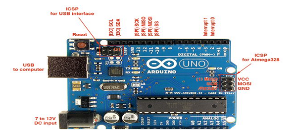
1) Arduino UNO R3
Arduino Uno R3 is a beginner-friendly microcontroller board based on the ATmega328P, operating at 5V with a 16 MHz clock speed. It features 14 digital I/O pins (6 with PWM), 6 analog inputs, and 32 KB flash memory. Powered via USB or an external supply (7–12V), it’s programmed using the Arduino IDE with simple C/C++ code. The board supports various shields, sensors, and communication options, making it ideal for robotics, IoT, home automation, and educational projects.
Fig 1. Arduino Uno R3
2) Ultrasonic Sensor
With an accuracy of 3 mm, the HC-SR04 ultrasonic sensor monitors distances ranging from 2 cm to 400 cm. It is made up of a receiver that picks up echoes and a transmitter that sends out sound waves at 40 kHz. VCC (5V power), ground, trigger(which starts the measurement with a 10 microsecond pulse),and Echo(which produces a pulse duration proportional the distance) are the sensor's four pins. Distance = (Echo pulse duration) x (Speed of Sound) / 2.
is the formula used to determine the distance. Because of its small size, affordability, and simplicity of integration with microcontrollers such as Arduino, this sensor is widely used It is extensively utilized for obstacle detection, smart homes, presence monitoring, distance measuring in robots, industry .automation.
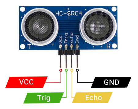
Fig 2. Ultrasonic Sensor
3) Servo Motor
The Tower Pro MG995 servo motor is a digital servo widely recognized for its durability, precision, and high-performance capabilities. Operating within a voltage range of 4.8V to 6V, it delivers a stall torque of 10–12 kg·cm, making it suitable for high-load applications. The motor features metal gear construction, ensuring reliability and a long service life, even under heavy loads. With a rotation range of 180° and a response speed of 0.2 seconds per 60° at 4.8V, the MG995 provides accurate and swift angular movement. Its 3-wire connection includes power (Vcc), ground (GND), and a PWM signal input for precise control. The MG995 is commonly used in robotics, remote-controlled vehicles, and automation projects requiring precise positioning and movement. Its compatibility with microcontrollers such as Arduino and its robust design make it an excellent choice for various educational and industrial applications.
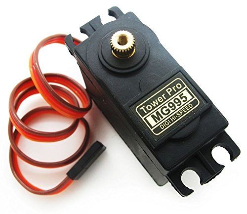
Fig 3 Servo Motor
4) Working
A servo motor that allows the ultrasonic sensor to dynamically sweep across a 180-degree arc gives the project's environment mapping capabilities a dynamic component. The Arduino Uno microprocessor controls this sweeping action, which guarantees thorough coverage of the area. The pan-and-tilt mechanism of the servo motor improves the system's responsiveness and flexibility by enabling dynamic perspective adjustment. This capability is especially helpful in situations when object tracking and real-time monitoring are essential.
The precision of the system is enhanced by the iterative data collection procedure that uses both forward and reverse sweeps. A more reliable depiction of the environment is produced by further refining the dataset through the averaging of distance measurements made during the reverse sweep. In addition to providing a visual depiction of spatial data, the resulting polar plot is a useful tool for autonomous systems' decision-making.
The project establishes the foundation for future developments in adaptive robotics in addition to its immediate uses in autonomous navigation and obstacle avoidance. A comprehensive approach to environmental awareness is demonstrated by the cooperative integration of intelligent data processing, servo control, and ultrasonic sensing. In addition to addressing present robotics and surveillance issues, this strategy presents the system as a flexible answer for upcoming advancements in smart infrastructure, environmental monitoring, and other fields. The research demonstrates how hardware and software components can be combined to form complex, perceptive systems that can intelligently navigate.
5) Block Diagram
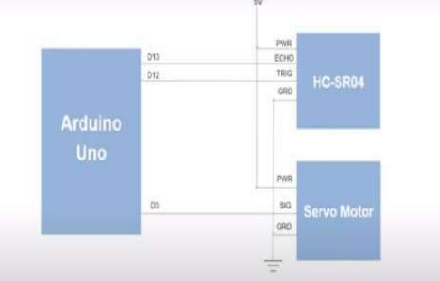
Fig 4 Block diagram
The schematic depicts a simple configuration for an Arduino Uno-based project that probably entails using distance measurements to operate a servo motor. As the microcontroller, the Arduino Uno supplies the project's processing power. Digital pins D13 and D12 are used to link an HC-SR04 ultrasonic sensor to the Arduino. By sending out sound waves and timing how long it takes for the echo to return, this sensor can determine how far away an item is. After that, the Arduino processes the distance data. Additionally, the Arduino has a servo motor attached to it, most likely on digital pin D9. The servo motor's position will be controlled by the Arduino using the distance information from the HC-SR04 sensor; depending on how close an object is, it may rotate to a particular angle. The diagram displays the ground connections (GND) and power connections (PWR) required for the servo motor and sensor. A robotic arm that can grip objects at varying distances or an automated system that can move a camera or other device according to the distance to a target are just two examples of the many uses for this configuration.
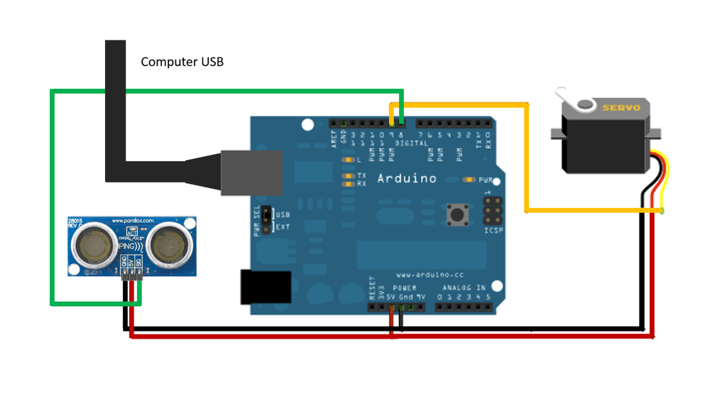 Fig 5 Circuit Design
6) Flow Chart
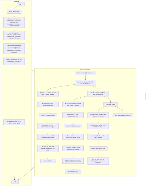
E. Software Requirements
The MATLAB script, acting as the intelligence hub, engages in real-time communication with the Arduino Uno through serial connectivity. This dynamic interaction allows the Arduino Uno to continuously send distance data to MATLAB during the servo motor sweeping motion, and MATLAB then performs critical tasks such as data logging, reverse sweeping, and data averaging to increase the accuracy and reliability of the spatial mapping dataset. Polar plot visualizations created by MATLAB provide
A valuable tool for gaining a deeper understanding of the environment. Applications such as autonomous navigation and obstacle avoidance. The adaptability and responsiveness of the system are highlighted by MATLAB's ability to Organize complex interactions between hardware components. Thanks MATLAB seamless integration of data analysis and visualization processes
Transform raw distance data into complex spatial maps the potential for intelligent systems to understand and navigate dynamic
environments. It combines hardware and software components. It forms the basis of the project and highlights the importance of MATLAB A sophisticated platform for real-time analysis and visualization in advanced applications of robotics and automation.
IV. RESULTS
A. Less Number Of Objects
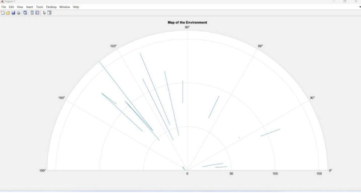
The above image represents semi-circular graph as output console window as we run the code and those spikes represent the objects indicating low density of objects surrounding the setup.
B. Moderate Number Of Objects
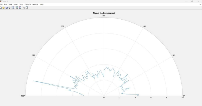
The above image represents semi-circular graph as output console window as we run the code and that distorted graph with no proper linearity in it represents there are moderate number of objects around it.
C. More Number Of Objects
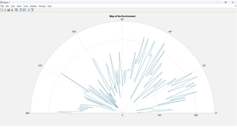
The above image represents semi-circular graph as output console window as we run the code and that distorted graph with no proper linearity and more spikes with more distortion represents there are more or max number of objects around it.
Conclusion
To sum up, the projects outlined have effectively shown the following: Creation of an advanced system for environmental mapping Integration of an ultrasound system with an ARDUINO UNO microcontroller incorporation of sensors and servo motors, enabling the scanning and active mapping of the environment. The movement driven by the servo will aid in producing a complete expression of the surroundings. A cyclical process of data gathering, incorporating both forward and reverse scans, enhances the precision of the spatial dataset. The choice of MATLAB as the main software platform underscores the significance of processing and visualizing data in real-time. The capabilities of MATLAB\'s polar diagrams offer a clear representation of the environment, making the system useful for tasks like autonomous navigation and obstacle evasion. The smooth interaction between hardware and software elements showcases the system\'s flexibility and ability to respond, illustrating its potential to address various real-world challenges. This initiative not only acts as a practical example of ecological mapping but also sets the stage for upcoming advancements in adaptive and perceptual robotics. The collaboration of ultrasound technology, ultrasonic sensors, servo mechanisms, and smart data processing will foster advancements in fields such as robotics, surveillance, and intelligent infrastructure. In conclusion, the project emphasizes the necessity of bringing together multiple disciplines to develop smart systems capable of understanding and engaging with ever-changing.
References
[1] Object Detection Using Radar: E. Karthika, K. Amutha, S. J. Prabhu, S. J. K. Jerushia and H. Padmapriya, \"Object Detection Using Radar,\" 2018 International Conference on Current Trends towards Converging Technologies (ICCTCT), Coimbatore, India, 2018. [2] Object Identification using Super Sonic Sensor: Arduino Object Radar: N. Gupta and A. K. Agarwal 2018 International Conference on System Modeling & Advancement in Research Trends (SMART), Moradabad, India, 2018
Copyright
Copyright © 2025 Adithya Phani Thota. This is an open access article distributed under the Creative Commons Attribution License, which permits unrestricted use, distribution, and reproduction in any medium, provided the original work is properly cited.

Download Paper
Paper Id : IJRASET66685
Publish Date : 2025-01-26
ISSN : 2321-9653
Publisher Name : IJRASET
DOI Link : Click Here
 Submit Paper Online


