Ijraset Journal For Research in Applied Science and Engineering Technology
- Home / Ijraset
- On This Page
- Abstract
- Introduction
- Conclusion
- References
- Copyright
Hydrology and Sediment Yield Analysis in the Jehlum River in Jammu & Kashmir, Employing the SWAT Model
Authors: Dr. Bashir Ahmad Pandit
DOI Link: https://doi.org/10.22214/ijraset.2024.63694
Certificate: View Certificate
Abstract
The Jhelum originates in the Indian-administered part of the Kashmir region, in western Jammu and Kashmir union territory, in Vernag, from a deep spring. The river flows through the Vale of Kashmir and meanders northwest from the northern slope of the Pir Panjal Range to Wular Lake in Srinagar, which regulates its flow. The Jhelum emerges from the lake and flows west, forming a valley with nearly perpendicular sides that passes the Pir Panjal at a depth of around 7,000 feet (2,100 meters). The Jhelum meets the Kishanganga River near Muzaffarabad, the administrative hub of Azad Kashmir in the Pakistani-administered region of Kashmir. From there, it bends southward, forming a portion of the border between Khyber Pakhtunkhwa province, Pakistan, to the west, and Azad Kashmir to the east. The southwest monsoon, which delivers intense rainfall to the Indian subcontinent from June to September, and the melting from the Himalayan and Karakoram ranges in the spring both significantly influence the hydrology of the Jhelum River. On the Jhelum, the maximum flood discharges are greater than one million cubic feet (28,300 cubic meters) per second. The river level is significantly lower in the winter than it is in the summer since there is less rain during that season. The large-scale model currently lacks the spatial and temporal precision needed to precisely estimate the sediment load and yield from tributaries and sub-basins that enter the Jehlum mainstream. In order to measure the sediment load and spatial sediment yield in the river Jehlum as well as to evaluate the long-term basin hydrology, the SWAT model was used in this work. At a monthly time step, the model was verified and calibrated between 2000 and 2020. In the Jehlum River, surface runoff accounted for 66% of the total streamflow, lateral flow for 11%, and groundwater contribution for 33%. The sediment yield grew by 4.5% between 2014 and 2020, from 334.6 tons s?1 to 349.6 tons s?1. This is the average annual sediment yield expressed in absolute terms. The Jehlum River sub-basins\' essential soil erosion-prone locations can be clearly identified and prioritized using the calculated sediment yield and a spatial soil erosion map.
Introduction
I. INTRODUCTION
One of the fundamental elements of river geomorphology is sediment transport, which is essential to the upkeep of fluvial environments like channel systems, floodplains, wetlands, and estuaries as well as the balance between deposition and erosion, which typically happens alongside rivers in natural, undisturbed systems. Anthropogenic activities have been seen to significantly alter water discharge and sediment loads in dynamic river conditions during the last few decades. It has been observed that major rivers around the world—the Yangtze, Yellow, and Mekong Rivers in Asia; the Colorado and Nile in America; the Ebro in Europe; and the Congo and Nile in Africa—supply less sediment as a result of human activity. There have been disastrous morphological changes as a result.
Large hydroelectric dam construction has been increasing recently in developing nations, especially in river basins with high biodiversity like the Amazon, Congo, and Mekong, despite the fact that significant losses are being seen in these biologically significant areas. The transboundary of Jehlum River divides Pakistan and India into two nations. The Upper Jehlum River Basin in India and the Lower Jehlum River Basin in Pakistan are the two divisions of the river basin. Although the Jehlum River has the capacity to generate over 900 MW of power, only roughly 720 MW are produced currently. The Jehlum River has had dams built on it since the 1980s. Reduction of the sediment discharge into the floodplain and estuaries at an alarming rate is one of the most obvious changes brought about by the construction of massive hydroelectric dams upstream. The Jehlum River reservoir impoundment in particular is at risk of ageing due to the possibility of storage capabilities being limited by the sediment. The geomorphology of the floodplains, and especially the Wular Lake, depends on sediment in the Jehlum River.
It also supplies vital nutrients for the lake's rich ecosystem. The geographical and temporal resolution to precisely ascertain the portion of the sediment load that originates from tributaries entering the Jehlum mainstream remains inadequate due to the paucity of sediment monitoring data for both suspended and bed loads in the Jehlum Rivers and their tributaries. Consequently, there was no agreement established regarding sediment baselines. Studying the Jehlum River basin has become difficult due to its cross-border distribution. In order to establish sustainable management of water resources at the river basin scale, modeling is highly valued as it can be used to assess available water resources, pinpoint causes of pollution, and enhance sustainable development.
One of the most widely used eco-hydrological models in the world today is the Soil and Water Assessment Tool (SWAT) model. In many nations, the SWAT model has proven to be quite trustworthy; the majority of studies have reported statistical values that are above satisfactory levels. A growing number of studies have been carried out for certain catchments located in various SEA countries, leading to partial analysis of the Jehlum river system with SWAT being carried out partly. A SWAT model has been attempted in several recent studies for a variety of purposes in the Jehlum River, including hydrology, sediment to water quality, land use/climate scenarios, and others. As previously shown, the SWAT model has been used in some portions of the basin by earlier studies. The present investigation employed the SWAT model to evaluate the long-term hydrology of the Jehlum River. The focus was on the water balance components and the respective contributions of the basin's compartments to the water yield. Additionally, the study aimed to quantify the sediment load and spatial sediment yield.
II. METHODOLOGY
A. Study Area

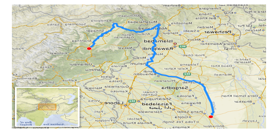
In the Indian part of Kashmir, the Jhelum originates from a deep spring in Vernag in western Jammu & Kashmir. The river flows through the Vale of Kashmir and meanders northwest from the northern slope of the Pir Panjal Range to Wular Lake in Srinagar, which regulates its flow. The Jehlum River is 725 KM long overall.
B. Data on Sediment and Discharge
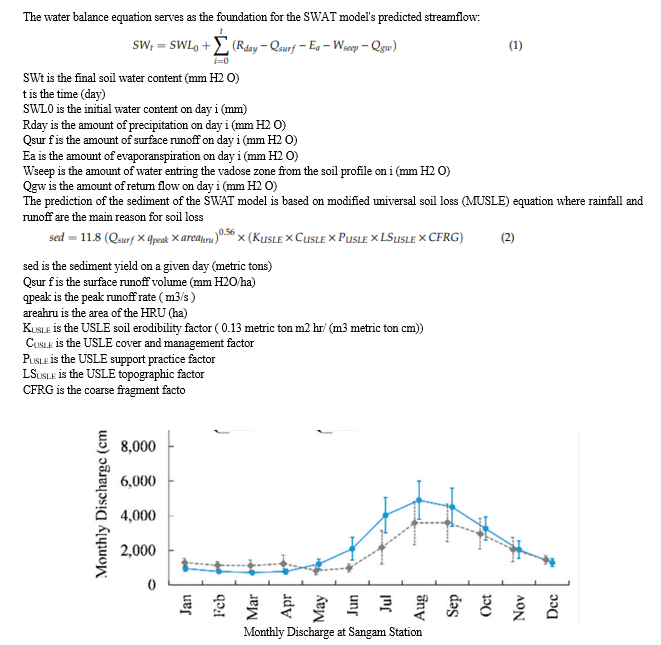
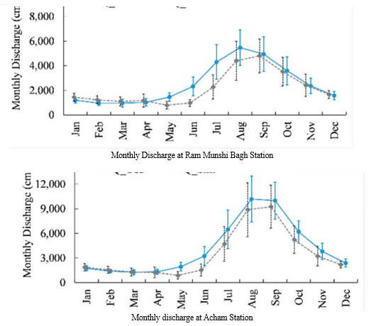
The department of irrigation and flood control provided the sediment data (recorded monthly) and streamflow data (recorded daily) used in this investigation. Along the main Jehlum river, there are three gauge stations for outflow. (Sangam, Ram Munshi Bagh and Acham, The study has extensively utilized the total suspended sediment (TSS) concentration from the Water Quality Monitoring Network dataset for estimating sediment load. The TSS concentrations were acquired by monthly water quality survey. At each site, the TSS samples were taken at a depth of 0.50 m below the water's surface in the center of the mainstream cross-section. The samples were examined in approved labs using the TSS analysis suggested analytical method (2540-D-TSS-SM). The Load Estimator (LOADEST) tool was utilized to estimate the sediment loads at three distinct locations. It should be mentioned that the bed-load, or roughly 1.25% of the suspended sediment load, was not included in our analysis.
C. Conceptual Model of SWAT
A physically-based, semi-distributed agro-hydrological simulation model, SWAT works at the watershed scale with time steps ranging from sub-daily to annual. In order to forecast how management decisions would affect the yields of water, sediment, and agricultural chemicals in catchments that are not yet ungauged, SWAT was created. The strength of the model rests in its capacity to simulate dissolved and particulate materials continuously over extended periods of time in large, complicated catchments with fluctuating weather, soils, and management circumstances. By discretizing into sub-basins, which are further separated into hydrological response units (HRUs) with uniform land use, soil type, and slope, SWAT can be used to evaluate small or expansive catchments.


D. Configuring the SWAT Model and Providing Data for the Jehlum River
The entire 725 km from the most upstream point of the Jehlum River Basin is covered by the SWAT model. Three zones comprise the Jehlum SWAT application for this study. as the availability of the sediment and streamflow records utilized in this work to set up the SWAT.
Every piece of data was compiled from a variety of sources.
The Indian Metrological Department provided the precipitation that was used in this investigation (IMD) The Multi-Error-Removed Improved-Terrain DEM (MERIT DEM) was utilized in the investigation. Multiple error components (absolute bias, stripe noise, speckle noise, and tree height bias) were eliminated in order to create the MERIT DEM. The topographic conditions of the SWAT Model setup for the Jehlum River are represented by the distribution of elevation, which ranges from 2 m to 1321 m. The Jehlum River's land use distribution was obtained at a resolution of one kilometer from the Global Land Cover 2000 Database (www.usgs.gov). The distribution of land use was obtained from the FAO's Global Soil Data (www.fao.org/).
E. Validation and Calibration of the SWAT Model
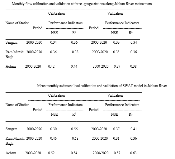
Every HRU (hydrologic response unit) has its total hydrologic balance simulated by the SWAT, and the model output is available in daily, monthly, and annual time increments. The SWAT2012 version was employed in this investigation. The calibration was carried out manually by comparing the information from the literature review with the observed data for the sediment and overall hydrological components. Potential evapotranspiration was calculated using the Penman-Monteith method. At the monthly time step, parameters governing the groundwater behavior in the model that rely on spatial data have been calibrated using literature. Every sub-station had its parameters verified and calibrated (based on the gauge stations).
The calibration findings demonstrated the significance of various parameters in the flow analysis of the Jehlum River, including Soil_AWC, Soil_K, and ALPHA_BF (groundwater parameter). Based on soil use, the CN2 parameter is relevant to runoff quantity. The quantity of soil-water interactions in the region's different soil types is correlated with Soil_K and Soil_AWC. In order to lessen the effect of streamflow peaks on erosion rate and sediment load at reaches, the parameter PRF_BSN has been calibrated for sediment load calibration. In contrast, the USLE_K parameter has been calibrated based on the type of permafrost in order to slow down erosion in comparison to literature reviews.

Conclusion
The Jehlum River\'s sediment erosion yield and water balance components were evaluated using the SWAT model. Along the Jehlum mainline, six sediment stations and three hydrological stations were used to calibrate and validate the model. The model\'s performance was confirmed by the calibration and valuation results to be extremely good for monthly flow and satisfactory for monthly sediment. Groundwater was responsible for about half of the total streamflow of the Jehlum River, which was a significant contribution. Meanwhile, surface runoff contributed one-third of the streamflow. Due to snowmelt, the Upper Jehlum Basin provided 64% of the average flow and is particularly significant during the dry season. It is significant to highlight that the Jehlum\'s slope and type of land use may be the primary determinants of the basin\'s sediment output. The study\'s findings will help with comprehending the derived sediment output and provide a spatial soil erosion map that clearly shows where the critical soil erosion-prone parts of the Jehlum River\'s sub-basins are and how important they are. A map of the sediment loading in the Jehlum River Basin is also provided by this study, which may limit storage capacity, raise the possibility of aging infrastructure, and result in appropriate management plans for this area. The baseline data from sediment studies for the sustainable watershed management plan may also represent the study\'s output.
References
[1] Moran, E.F.; Lopez, M.C.; Moore, N.; Müller, N.; Hyndman, D.W. Sustainable hydropower in the 21st century. Proc. Natl. Acad. Sci. USA 2018, 115, 11891–11898. [CrossRef] [2] Kondolf, G.M.; Schmitt, R.J.; Carling, P.; Darby, S.; Arias, M.; Bizzi, S.; Castelletti, A.; Cochrane, T.A.; Gibson, S.; Kummu, M.; et al. Changing sediment budget of the Mekong: Cumulative threats and management strategies for a large river basin. Sci. Total. Environ. 2018, 625, 114–134. [CrossRef] [PubMed] [3] Peng, J.; Chen, S.; Dong, P. Temporal variation of sediment load in the yellow river basin, China, and its impacts on the lower reaches and the river delta. Catena 2010, 83, 135–147. [CrossRef] [4] Galipeau, B.A.; Ingman, M.; Tilt, B. Dam-induced displacement and agricultural livelihoods in China’s Mekong Basin. Hum. Ecol. 2013, 41, 437–446. [CrossRef] [5] Rex, W.; Foster, V.; Lyon, K.; Bucknall, J.; Liden, R. Supporting Hydropower: An Overview of the World Bank Group’s Engagement; The World Bank: Washington, WA, USA, 2014. [6] Adamson, P.T.; Rutherfurd, I.D.; Peel, M.C.; Conlan, I.A. The Hydrology of the Mekong River. In The Mekong Biophysical Environment of an International River Basin; Campbell, I.C., Ed.; Elsevier Inc.: Amsterdam, The Netherlands, 2009; pp. 53–76. [7] Hecht, J.S.; Lacombe, G.; Arias, M.E.; Dang, T.D.; Piman, T. Hydropower dams of the Mekong River basin: A review of their hydrological impacts. J. Hydrol. 2019, 568, 285–300. [CrossRef] [8] Mekong River Commission, MRC. Assessment of Basin-Wide Development Scenarios—Main Report. Mekong River Commission Vientiane; MRC: Phnom Penh, Cambodia, 2011. [9] Schmitt, R.; Rubin, Z.; Kondolf, G. Losing ground-scenarios of land loss as consequence of shifting sediment budgets in the Mekong Delta. Geomorphology 2017, 294, 58–69. [CrossRef] [10] Fu, K.; He, D.; Chen, W.; Ye, C.; Li, Y. Impacts of dam constructions on the annual distribution of sediment in Lancang-Mekong River Basin. Acta Geogr. Sin.-Chin. Ed. 2007, 62, 14. [11] Milliman, J.D.; Syvitski, J.P. Geomorphic/tectonic control of sediment discharge to the ocean: The importance of small mountainous rivers. J. Geol. 1992, 100, 525–544. [CrossRef] 22. Gupta, A.; Liew, S. The Mekong from satellite imagery: A quick look at a large river. Geomorphology 2007, 85, 259–274. [CrossRef] [12] Walling, D.E. The changing sediment load of the Mekong River. AMBIO: J. Hum. Environ. 2008, 37, 150–157. [CrossRef] Water 2020, 12, 3503 23 of 25 [13] Stephens, J.; Allison, M.; di Leonardo, D.; Weathers, H., III; Ogston, A.; McLachlan, R.; Xing, F.; Meselhe, E. Sand dynamics in the Mekong River channel and export to the coastal ocean. Cont. Shelf Res. 2017, 147, 38–50. [CrossRef] [14] Kummu, M.; Penny, D.; Sarkkula, J.; Koponen, J. Sediment: Curse or blessing for Tonle Sap Lake? Ambio A J. Hum. Environ. 2008, 37, 158–163. [CrossRef] [15] Lu, X.; Kummu, M.; Oeurng, C. Reappraisal of sediment dynamics in the lower Mekong River, Cambodia. Earth Surf. Process. Landforms 2014, 39, 1855–1865. [CrossRef] [16] Sok, T.; Oeurng, C.; Kaing, V.; Sauvage, S.; Kondol, G.M.; Perez, J.M. Assessment of sediment load variabilities in the tonle sap and lower Mekong Rivers, Cambodia. Manuscript submitted for Publication. Authorea 2020. [CrossRef] [17] Piman, T.; Shrestha, M. Case Study on Sediment in the Mekong River Basin: Current State and Future Trends; Stockholm Environment Institute: Stockholm, Sweden, 2017. [18] Bouraoui, F.; Benabdallah, S.; Jrad, A.; Bidoglio, G. Application of the SWAT model on the Medjerda river basin (Tunisia). Phys. Chem. Earth Parts A/B/C 2005, 30, 497–507. [CrossRef] [19] Arnold, J.G.; Srinivasan, R.; Muttiah, R.S.; Williams, J.R. Large area hydrologic modeling and assessment part I: Model development. JAWRA J. Am. Water Resour. Assoc. 1998, 34, 73–89. [CrossRef] [20] Arnold, J.G.; Moriasi, D.N.; Gassman, P.W.; Abbaspour, K.C.; White, M.J.; Srinivasan, R.; Santhi, C.; Harmel, R.D.; van Griensven, A.; van Liew, M.W.; et al. SWAT: Model use, calibration, and validation. Trans. ASABE 2012, 55, 1491–1508. [CrossRef] [21] Bieger, K.; Arnold, J.G.; Rathjens, H.; White, M.J.; Bosch, D.D.; Allen, P.M.; Volk, M.; Srinivasan, R. Introduction to SWAT+, A completely restructured version of the soil and water assessment tool. JAWRA J. Am. Water Resour. Assoc. 2016, 53, 115–130. [CrossRef] [22] Tan, M.L.; Gassman, P.W.; Raghavan, S.; Arnold, J.G.; Yang, X. A Review of SWAT studies in southeast Asia: Applications, challenges and future directions. Water 2019, 11, 914. [CrossRef] [23] Al-Soufi, R. Soil erosion and sediment transport in the Mekong basin. In Proceedings of the 2nd Asia Pacific Association of Hydrology and Water Resources Conference, Suntec International Convention and Exhibition Center, Singapore, 5–8 July 2004; pp. 47–56. [24] Shrestha, B.; Cochrane, T.A.; Caruso, B.S.; Arias, M.E.; Piman, T. Uncertainty in flow and sediment projections due to future climate scenarios for the 3S Rivers in the Mekong Basin. J. Hydrol. 2016, 540, 1088–1104. [CrossRef] [25] Mohammed, I.N.; Bolten, J.; Srinivasan, R.; Lakshmi, V. Satellite observations and modeling to understand the lower Mekong River Basin streamflow variability. J. Hydrol. 2018, 564, 559–573. [CrossRef]
Copyright
Copyright © 2024 Dr. Bashir Ahmad Pandit. This is an open access article distributed under the Creative Commons Attribution License, which permits unrestricted use, distribution, and reproduction in any medium, provided the original work is properly cited.

Download Paper
Paper Id : IJRASET63694
Publish Date : 2024-07-20
ISSN : 2321-9653
Publisher Name : IJRASET
DOI Link : Click Here
 Submit Paper Online

