Ijraset Journal For Research in Applied Science and Engineering Technology
- Home / Ijraset
- On This Page
- Abstract
- Introduction
- Conclusion
- References
- Copyright
Impact of Land Use Land Cover on erosion in the Anantnag district of Jammu and Kashmir (India)
Authors: Dr. Bashir Ahmad Pandit
DOI Link: https://doi.org/10.22214/ijraset.2024.65977
Certificate: View Certificate
Abstract
Soil erosion is a complex and natural phenomenon that occurs when productive surface soil is detached by physical forces such as water and wind, exposing subsurface soil and causing sedimentation in reservoirs. It is influenced by a variety of factors, including topographic slope location, vegetation and soil composition, all of which have a significant impact on the erosional activity of soil. Globally, soil erosion is a serious issue. Human activities are responsible for the degradation of 1,964.4 million hectares (Mha) of land worldwide. Water erosion affects 1,903 Mha of this area, while wind erosion affects 548.3 Mha. Water erosion has been identified as the primary driver of land degradation caused by anthropogenic activities over 1094 million hectares of land worldwide, or 56% of the total. For various reasons, India loses roughly 5334 m-tones of soil year. Compared to 29% in the rest of the nation, 35.86% of Jammu and Kashmir\'s (J&K) total area is affected by land degradation (ISRO, 2016). The UTs of J&K and Ladakh lose 20 tons of soil per hectare per year, which is significantly more than the 16.35 t/ha/year national average (SWCD J&K, 2016). Water availability and erosion are intimately related, particularly when it comes to crop growth and productivity. The elements that contribute to soil erosion are topography, porosity/permeability, soil cover, soil texture, and soil structure. Problem quantification has recently been seen as a pressing necessity to create acceptable and effective methods to reduce the deterioration of valuable land.
Introduction
I. INTRODUCTION
Significant runoff from the majority of rainfall and snowmelt results in significant erosion and sediment transfer to rivers, depleting soil resources and contributing to downstream adverse off-site effects like flooding, pollution, and siltation of reservoirs and water bodies. Numerous elements, such as soil quality, terrain, vegetation and land use, conservation strategies, and rainfall patterns, influence soil water erosion. Rainfall is necessary for runoff and soil water erosion, and land use patterns influence the amount of runoff and soil erosion in addition to rainfall intensity and quantity. The impact of high intensity rainfall coupled by runoff results in enormous soil loss over increasing slope length and this effect becomes more harmful with the steepness. The physical features of the watershed, including drainage area, elevation, slope, topography, basin shape, soil type, land use, orientation, vegetation, and so forth, influence the erosive action of runoff, which is the catchment's reaction to precipitation. Erosion is caused by the interaction of runoff transport and rainfall in a catchment area. It is difficult and time-consuming to forecast how much silt and runoff will enter rivers and streams from the land. When soil is unable to absorb rainfall or remove it through transpiration and in-situ infiltration, surface runoff, also known as overland flow, occurs. Although land use and cover are two distinct concepts, they are frequently used interchangeably. The term "land cover" describes the physical attributes of the earth's surface as they are represented in the distribution of flora, soil, water, and other land features, including those that are exclusively the result of human activity, such as settlements. However, land-use describes how people have used land and their environment, typically emphasizing the land's usefulness for economic activity. Land usage and land cover are strongly related to the features of the earth's surface. Determining the type and process of runoff requires knowledge on land use and land cover. It is a fundamental feature of a watershed that influences infiltration. In the hydrologic cycle, land use/land cover (LU/LC) is essential for water movement and mainly helps to decrease overland flows. Since the LULC impacts and adjusts numerous other interrelated processes, substantial changes in the LULC may have an impact on the general health and function of a watershed. The hydrological response in the form of runoff is an integrated indication of catchment conditions. The dynamic, pervasive, and quickening process of changing the composition of land use and land cover is mostly caused by human activity and natural processes. Any watershed's soil loss condition must be known in order to create a conservation plan. Quantifying the local soil is the first step towards effectively managing the deposition and sedimentation processes in rivers and reservoirs within any watershed. An estimated 10-15 t/ha/yr of soil erosion occurs in District Anantnag (SWCD J&K, 2016).
The primary source of water for the water receiving stations Bindu and Sagam is the river Bringi, which flows through the watershed. If erosion in the area is not controlled, silt will be deposited in the reservoir, lowering its capacity and lowering the quality of the water. The goal of this study is to determine how LU/LC and soil erosion are related.
A variety of erosion models, including the Universal Soil Loss Equation/Revised Universal Soil Loss Equation (USLE/RUSLE), the Soil Erosion Model for Mediterranean Regions (SEMMED), the Areal Non-point Source Watershed Environment Response Simulation (ANSWERS), the Water Erosion Prediction Project (WEPP), the Limburg Soil Erosion Model (LISEM), the European Soil Erosion Model (EUROSEM), the Simulator for Water Resources in Rural Basins (SWRRB), the Soil and Water Assessment Tool (SWAT), the Agricultural Non-point Source pollution model (AGNPS), and others were used in the regional scale assessment in order to estimate soil loss and create suitable conservation and management plans. Every model has unique properties and ranges of applications. Even though RUSLE is an empirical model, it has a wide range of applications.
It not only calculates the ungauged watershed's soil loss but also offers data on how erosion varies across space. By accounting for the effects of rainfall, soil properties, topography, vegetation cover, and conservation measures, the RUSLE model calculates the average annual soil erosion of the study area. These RUSLE characteristics exhibit spatial variability.
The different criteria determine which RS and GIS approaches are used to calculate the watershed's soil loss. These parameters are taken from the Digital Elevation Model (DEM), soil data, monthly and annual rainfall data, and the water shed's LULC map.
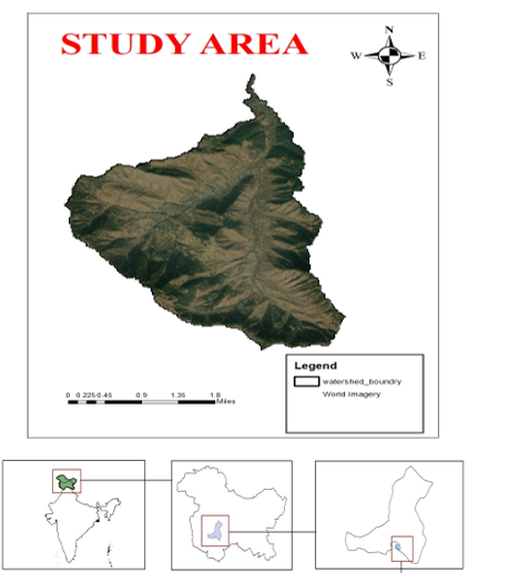
The present study is aiming at estimate average yearly soil loss in watershed with following objectives:
- To use RS and GIS approaches to estimate soil erosion using RUSLE.
- To evaluate how the watershed's land use and land cover changed between 1990 and 2020.
- To ascertain how changes in land cover and use affect soil erosion.
II. MATERIALS AND METHODS
A. Land use / land cover (LULC)
Agriculture, forests, horticulture, vegetation, and bare ground were the main land uses that predominated in this watershed. The majority of the watershed was made up of forest, followed by barren terrain and agriculture, with paddy and maize being the main crops farmed from June to August. Peas and other crops like mustard were planted from September to November. The two main horticultural products grown in the region are apples and walnuts.
1) Soil Characteristics
The paedogenic processes and parent material differ greatly because the watershed is located in the south of the Kashmir valley, which has a very diverse range of relief and physical features. The district's soils vary widely in their morphological, edaphic, physical-chemical, and mineralogical characteristics. The district's soils range widely in origin from lacustrine to alluvial. Peaty soils, karewa soils, alluvial soils, and mountain soils are the primary soil types in the district.
2) Climate
The district of Anantnag has a temperate climate, with summers that are moderately hot and winters that are extremely cold. The most precipitation comes in the form of snow during the winter months. Temperatures below freezing are observed between November and January.
3) Rainfall
The total annual rainfall in 2020 was 1318 mm, according to rainfall data. The Department of Meteorology station Kokernag (Anantnag) supplied the rainfall data. The middle of March into May is when the rain usually stops. The majority of the rainfall occurs in the months of April and May. The study area's rainfall distribution for the years 2020, 2010, 2000, and 1990 is displayed in Fig.
4) Temperature
According to a comparison of temperature data from the time period considered in this study, which is between -6.80C and 340C, summer is extremely hot, with July and August being the hottest months, and winter is extremely cold, with sub-zero temperatures reported from November to January. July has the highest average temperature of 24.5°C, while January has the lowest average temperature of minus 2.0°C.
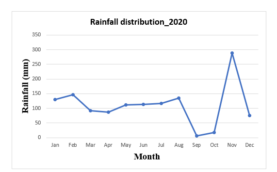
Monthly Rainfall distribution in (mm) of watershed in year 2020, district Anantnag, Jammu and Kashmir
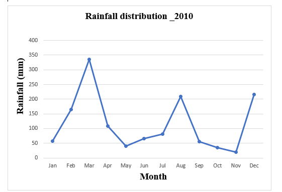
Monthly Rainfall distribution in (mm) of watershed in year 2010, district Anantnag, Jammu and Kashmir
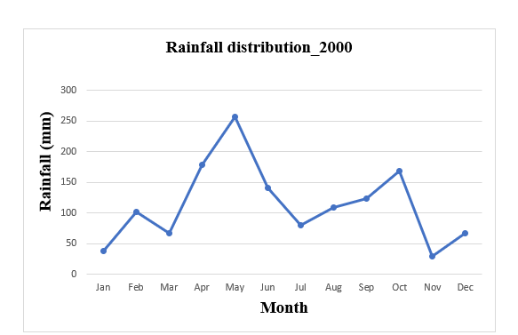
Monthly Rainfall distribution in (mm) of watershed in year 2000, district Anantnag, Jammu and Kashmir
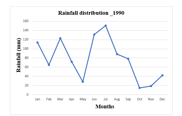
Monthly Rainfall distribution in (mm) of watershed in year 1990, district Anantnag, Jammu and Kashmir

The sources of the data used
B. Cover and Management
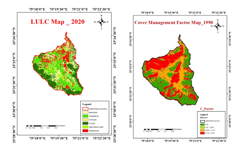
The ratio of soil loss in a tilled continuous fallow area to that in an area with defined cover and management is known as the crop cover and management factor (C). Cover, cropping order, productivity level, growing season duration, tillage techniques, residue management, and the anticipated timing of erosive rainstorms all have a combined impact on when to plant and harvest in a given area. The factor that governs how land use affects soil loss Wishmeier and Smith's criteria (1978) were used to compute the values of the cover and management activities.
Different c values are utilized for different land uses in this approach, which is connected to land usage, canopy, and cover conditions. The range of values for the c factor is 0.04 to 1.00. The land is well protected when the value is close to zero. The C-Factor value was extracted from Table 3.6, which was supplied by the Soil and Water Conservation Society in 2003.

Identification of changes in land use and land cover
Remote sensing and GIS, two effective methods for obtaining precise and timely data on the spatial distribution of land use/land cover changes over wide areas, were used to study the land use/land cover change in the watershed. Finding land use/land cover on digital photos that alter aspects of interest over two or more dates is the goal of the change detection procedure (Muttitanon and Tripathi, 2005). Together with ground measurements, remotely sensed pictures of the study region from LANDSAT-5 (TM), LANDSAT-7 (TM), and LANDSAT-8 (OLI) for the years 1990, 2000, 2010, and 2020, respectively, were used to examine changes in land cover and land use. The term "land use/land cover" refers to the thematic information about the types of features that are found on the earth's surface, and land utilization is linked to specific land cover and land usage. During modeling, land use is a fundamental feature of a watershed that influences infiltration as well as other hydrological processes like runoff, water flow, and soil erosion. The LULC map for 1990 and 2000 was created using processed Landsat-5 and Landsat-7 TM (30 m resolution) images, and the LULC map for 2010 and 2020 was created using Landsat-7 ETM and Landsat-8 OLI (30 m resolution) imagery. In order to extract the infrastructure layer, appropriate enhancement techniques were used to improve the details by switching the band combination from 1, 2, 3 to 3, 2.etc.
The catchment area's geomorphological elements have been determined based on visual interpretation of the FCC image.
C. Interpretation of Visual Images
- In order to categorize LU/LC classes by visual interpretation using image interpretation keys (photo-elements) like shape, size, tone, texture, shadow, site, and pattern, all four satellite images—Landsat-5 (1990), Landsat-7 TM (2000), Landsat-7 ETM (2010), and Landsat-8 OLI (2020)—were opened (one image at a time) in ArcGIS software.
- Used the extract by mask tool, an integrated feature of ArcGIS software, to clip the area of interest (AOI), or watershed
- To define the various features from the study region using polygons, a new vector shape file was made.
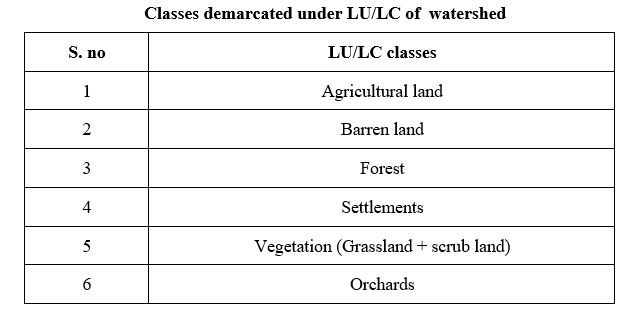
- Using on-screen visual image interpretation methodologies for all three satellite imagery, the six LULC classes—agriculture, forest, built-up, vegetation, orchards, and barren land—were delineated.
- The LU/LC maps were prepared using all four satellite imageries.
- Each class's area (ha) for each of the four classed images was determined.
- JPEG files of the LU/LC maps are then exported.
D. Analysis of LU/LC changes
- To analyze the changes over time, layers of Landsat-7 TM (2000) were superimposed on vector layers of Landsat-5 (1990).
- The UNION tool, a built-in feature in ArcGIS (Version 10.4.1) software, was used to join both layers.
- By comparing the classified shape data of Landsat-5 (1990) and Landsat-7 TM (2000), identify the locations where modifications have taken place.
- The area of each LU/LC class that has been classified has been shown and calculated (ha) in Microsoft Excel.
- After calculating the area for each class, the percentage of change was determined by subtracting Landsat-5 (1990) from Landsat-7 TM (2000).
- A matrix table for changes was created.
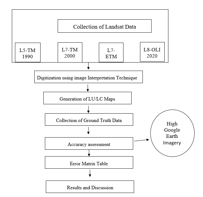
Flow chart of LULC change detection
E. Evaluation of accuracy
- For verification, LULC classified imagery was combined with the gathered ground truth data.
- Using the process described by Rwanga and Ndambuki (2017), the classified photos were verified by looking at historical satellite imagery for the years 2010 and 2020 on Google Earth.
- Using ground truth data, the accuracy of the LU/LC categorization of Landsat-5 (1990), Landsat-7 TM (2000), Landsat-7 ETM (2010), and Landsat-8 OLI (2020) was evaluated.
- For every satellite data set used for LU/LC classification, error matrix tables were created.
- For every LU/LC classification, the Kappa (K) coefficient and overall accuracy were determined.
Overall accuracy was calculated by using equation

F. LU/LC's effect on soil erosion
To determine how LU/LC classes affect soil erosion, use the RUSLE model. Renard et al. (1996) provided the RUSLE approach, which can be written as
Where,
A = Average soil loss per unit area by erosion (t/ha/yr),
R = Rainfall erosivity factor (MJ mm/ha/h/yr),
K = Soil erodibility factor (t h/MJ/mm),
L = Slope length factor,
S = Slope steepness factor,
C = Plant cover and management practice factor,
P = Conservation support practice factor
Conclusion
1) Forest areas (52.35 t/ha/yr), vegetation (15.88 t/ha/yr), agricultural land (9.1 t/ha/yr), orchards (5.66 t/ha/yr), and settlements (4.56 t/ha/yr) were the areas with the highest mean soil loss among the various LULC. 2) The watershed\'s estimated soil loss over the previous three decades was determined to be as follows: 1990–91 (0–16.6 t/ha/yr), 2000–01 (0–18.3 t/ha/yr), 2010 (0–19.1 t/ha/yr), and 2020 (0–22.08 t/ha/yr) in increasing order.
References
[1] Bhatt, B., Gupta, A. K. and Gogoi, G. 2006. Application of Remote Sensing and GIS for Detecting Land Use Changes: A Case Study of Vadodara. Available at http: //www. gisdevelopment. net/application/urban/sprawl/ remotesensing. Htm (last accessed on 14 September 2007). [2] Boggs, G. 2001. Christopher Devonport, Kenneth Evans and Patricia Puig. \"GIS?based rapid assessment of erosion risk in a small catchment in the wet/dry tropics of Australia.\" Land Degradation & Development 12(5): 417-434. [3] Bonilla, C. A., Reyes, J. L. and Magri, A. 2010. Water erosion prediction using the Revised Universal Soil Loss Equation (RUSLE) in a GIS framework, central Chile. Chilean Journal of Agricultural Research 70(1): 159-169. [4] Chang-Guang, W., De-Sheng, L., Wen-Fa, X., Peng-Cheng, W., Hao, M. and Zhi-Xiang, Z. 2011. Spatiotemporal distribution characteristics of rainfall erosivity in Three Gorges Reservoir Area. YingyongShengtaiXuebao, 22(1): 122-131. [5] Chauhan, H. B. and Nayak, S. 2005. Land use/land cover changes near Hazira Region, Gujarat using remote sensing satellite data. Journal of the Indian Society of Remote Sensing 33(3): 413-420. [6] Dabral, P. P., Baithuri, N. and Pandey, A. 2008. Soil erosion assessment in a hilly catchment of North Eastern India using USLE, GIS and remote sensing. Water Resources Management 22(12): 1783-1798. [7] Dabral, P. P., Baithuri, N. and Pandey, A. 2008. Soil erosion assessment in a hilly catchment of North Eastern India using USLE, GIS and remote sensing. Water Resources Management 22(12): 1783-1798. [8] Das, D. 2014. Identification of erosion prone areas by morphometric analysis using GIS. Journal of the Institution of Engineers (India): Series A 95(1): 61-74. [9] Dhruvanarayana, V. V. and Babu, R. 1983. Estimation of soil erosion in India. Journal of Irrigation and Drainage Engineering 109(4): 419-434. [10] Dimyati, M. U. H., Mizuno, K., Kobayashi, S. and Kitamura, T. 1996. An analysis of land use/cover change in Indonesia. International Journal of Remote Sensing 17(5): 931-944. [11] Dumas, P. and Printemps, J. 2010. Assessment of soil erosion using USLE model and GIS for integrated watershed and coastal zone management in the South Pacific Islands. In: Proceedings Interpraevent, International Symposium in Pacific Rim, Taipei, Taiwan pp. 856-866. [12] Efe, R. and Ciirebal, I. 2008. Erosion analysis of call in Creek Watershed (NW OF Turkey) using GIS based on RUSLE (3d) method. Journal of Applied Sciences 8(1): 49-58. [13] Farida, A. 1997. Evaluation of sulphur in some paddy growing soils of Kashmir. Thesis submitted to Sher-e-Kashmir University of Agricultural Sciences and Technology, Shalimar pp. 1-102. [14] Fernandez, R. B. and Dhorde, A. A. 2014. Assessment of spatio-temporal variations in land use land cover over pimipri chinch wad Municipal corporation using Remote sensing data. International Journal of Geomatics and Geosciences 4(4): 609-618. [15] Fernandez, R. B. and Dhorde, A. A. 2014. Assessment of spatio-temporal variations in land use land cover over pimipri chinch wad Municipal corporation using Remote sensing data. International Journal of Geomatics and Geosciences 4(4): 609-618. [16] Ghosh, K., De, S. K., Bandyopadhyay, S. and Saha, S. 2013. Assessment of soil loss of the Dhalai river basin, Tripura, India using USLE. [17] Han, D., Deng, J., Gu, C., Mu, X., Gao, P. and Gao, J. 2020. Effect of shrub-grass vegetation coverage and slope gradient on runoff and sediment yield under simulated rainfall. International Journal of Sediment Research 36(1): 29-37. [18] Ingle, V. K., Mishra, A. K., Sarangi, A., Singh, D. K. and Seghal, V. K. 2014. Hydrologic behaviour of Tapi river catchment using morphometric analysis. Journal of Applied and Natural Science 6(2): 442-450. [19] Karaburun, A. 2010. Estimation of C factor for soil erosion modeling using NDVI in Buyukcekmece watershed. Ozean Journal of Applied Sciences 3(1): 77-85. [20] Khadem, H. and Mermat, A. R. 2003. Micromorphology and classification of Argids and associated gypsiferous Aridisols from central Iran. Catena, 54(3): 439-455. [21] Kumar, V., Jain, S. K. and Singh, Y. 2010. Analysis of long-term rainfall trends in India. Hydrological Sciences Journal–Journal des Sciences Hydrologiques 55(4): 484-490. [22] Lu, D., Li, G., Valladares, G. S. and Batistella, M. 2004. Mapping soil erosion risk in Rondonia, Brazilian Amazonia: using RUSLE, remote sensing and GIS. Land degradation & development 15(5): 499-512. [23] Luo, H., Zhao, T., Dong, M., Gao, J., Peng, X., Guo, Y., Wang, Z. and Liang, C. 2013. Field studies on the effects of three geotextiles on runoff and erosion of road slope in Beijing, China. Catena 109: 150-156. [24] Maria, K., Soupios, P. and Vallianatos, F. 2009. Soil erosion prediction using the revised universal soil loss equation (RUSLE) in a GIS framework, Chania, Northwestern Crete, Greece. Environmental Geology 57(3): 483-497. [25] Mir, A. A., Ahmed, P., Bhat, P. A. and Singh, H. 2016. Analyzing Land Use/ Land Cover Change Using Remote Sensing and GIS Techniques in Pohru Watershed of Kashmir Valley. Journal of Research & Development pp. 16. [26] Mohamadi, M. A. and Kavian, A. 2015. Effects of rainfall patterns on runoff and soil erosion in field plots. International Soil and Water Conservation Research 3(4): 273-281. [27] Mohammed, S., Alsafadi, K., Talukdar, S., Kiwan, S., Hennawi, S., Alshihabi, O., Sharaf, M. and Harsanyie, E. 2020. Estimation of soil erosion risk in southern part of Syria by using RUSLE integrating geo informatics approach. Remote Sensing Applications: Society and Environment 20: 100375. [28] Moore, I. D. and Wilson, J. P. 1992. Length-slope factors for the Revised Universal Soil Loss Equation: Simplified method of estimation. Journal of soil and water conservation 47(5): 423-428. [29] Nagamani, K. and Ramachandran, S. 2003. Land use /Land cover in Pondicherry using remote sensing and GIS. In: Proceedings of the Third International Conference on Environment and Health (Eds. J. Martin, V. Bunch, M. Suresh and T. V. Kumaran) pp. 300-305. [30] Neitsch, S. L., Arnold, J. G., Kiniry, J. R., Williams, J. R. and King, K. W. 2005. Soil and water assessment tool theoretical documentation. Grassland. Soil and Water Research Laboratory, Temple, TX 14(15): 3307-3323. [31] Oldeman, L. R., Hakkeling, R. T. A., Sombroek, W. G. and Batjes, N. 1991. Global assessment of human-induced soil degradation (GLASOD. World Map of the Status of Human-Induced Soil Degradation 43(7): 323-328. [32] Pandey, A., Chowdary, V. M. and Mal, B. C. 2007. Identification of critical erosion prone areas in the small agricultural watershed using USLE, GIS and remote sensing. Water Resources Management 21(4): 729-746. [33] Pandey, A., Chowdary, V. M., Mal, B. C. and Billib, M. 2008. Runoff and sediment yield modeling from a small agricultural watershed in India using the WEPP model. Journal of Hydrology 348(3-4): 305-319. [34] Panditharathne, D. L. D., Abeysingha, N. S., Nirmanee, K. G. S. and Mallawatantri, A. 2019. Application of revised universal soil loss equation (Rusle) model to assess soil erosion in “Kalu Ganga” river basin in Sri Lanka. Applied and Environmental Soil Science pp. 1-15 [35] Patil, R. B. and Prasad, J. 2004. Characteristics and classification of some Sal (Shorearobusta)-supporting soils in Dindori district of Madhya Pradesh. Journal of the Indian Society of Soil Science 52(2): 119-125. [36] Pham, T. N., Yang, D., Knae, S., Oki, T. and Musiake, K. 2001. Application of RUSLE model on global soil erosion estimate. Proceedings of Hydraulic Engineering 45: 811-816. [37] Pimentel, D. 2006. Soil erosion: a food and environmental threat. Environment, development and Sustainability 8(1): 119-137. [38] Rai, R. K. and Mathur, B. S. 2007. Event-based soil erosion modeling of small watersheds. Journal of Hydrologic Engineering 12(6): 559-572. [39] Rashid, M., Kausar, R., Alvi, S. and Sajjad, M. R. 2015. Assessment of runoff and sediment losses under different slope gradients and crop covers in semi-arid watersheds. Soil and Environment 34(1): 6-7. [40] Rawat, J. S. and Kumar, M. 2015. Monitoring land use/cover change using remote sensing and GIS techniques: A case study of Hawalbagh block, district Almora, Uttarakhand, India. The Egyptian Journal of Remote Sensing and Space Science 18(1): 77-84. [41] Reis, S. 2008. Analyzing land use / land cover changes using remote sensing and GIS in Rize, North-East Turkey. Sensors 8: 6188-6202. [42] Renard, K. G. 1997. Predicting soil erosion by water: a guide to conservation planning with the Revised Universal Soil Loss Equation (RUSLE. United States Government Printing. [43] Renard, K. G., Foster, G. R., Weesies, G. A., McCool, D. K. and Yoder, D. C. 1996. Predicting soil erosion by water: A guide to conservation planning with the Revised Universal Soil Loss Equation (RUSLE. Agriculture handbook 703: 25-28. [44] Rwanga, S. S. and Ndambuki, J. M. 2017. Accuracy assessment of land use/land cover classification using remote sensing and GIS. International Journal of Geosciences 8(04): 611. [45] Saini, R., Aswal, P., Tanzeem, M., & Saini, S. S. 2019. Land Use Land Cover Change Detection using Remote Sensing and GIS in Srinagar, India. Int. J. Comput. Appl, 178: 42-50.
Copyright
Copyright © 2024 Dr. Bashir Ahmad Pandit. This is an open access article distributed under the Creative Commons Attribution License, which permits unrestricted use, distribution, and reproduction in any medium, provided the original work is properly cited.

Download Paper
Paper Id : IJRASET65977
Publish Date : 2024-12-17
ISSN : 2321-9653
Publisher Name : IJRASET
DOI Link : Click Here
 Submit Paper Online

