Ijraset Journal For Research in Applied Science and Engineering Technology
- Home / Ijraset
- On This Page
- Abstract
- Introduction
- Conclusion
- References
- Copyright
Structural Architecture and Mineralogical Relationship in Chitradurga Schist Belt, Dharwar Cration, South India
Authors: Pekham Ganguly
DOI Link: https://doi.org/10.22214/ijraset.2023.56342
Certificate: View Certificate
Abstract
The succession in the late Archaean supracrustal belts in the Chitradurga region begins with basal quartz-pebble conglomerates and quartzites which were deposited on a basement of tonalitic--granitic gneisses, ca. 3000 Ma, containing tracts and enclaves of older supracrustal rocks. The basal beds are overlain by basic metalavas and amphibolites interbedded with cross-bedded quartzites and siliceous phyllites. This series passes up into siliceous phyllites, locally containing a large lenticular mass of polymict conglomerate (Talya Conglomerate), overlain by banded iron formations and siliceous phyllites including sporadic chert pebble conglomerates. Greater subsidence in part of the basin accommodated greater thicknesses of basic volcanic and acid pyroclastic rocks, the latter being more abundant at higher levels. With progressive deepening of the whole basin, finegrained, graded greywackes and local polymict conglomerates (Aimangala Conglomerate) were deposited ; the turbidite sequence forms the youngest sedimentary rocks exposed.Estimated total stratigraphic thickness is at least 10 km in deeper parts of the basin. Deformation led to a series of upright anticlines and synclines and related LS fabrics with extreme variations in plunge of the coaxial fold axes and L fabrics within axial surfaces which maintain a steep orientation. Low-grade metamorphism outlasted the deformation. Sedimentation and volcanism in the Chitradurga supracrustal belt is linked to variable subsidence of the basement foundation, probably as a result of rifting. The structural evolution of the belt followed as a direct continuation of events that controlled the depositional and volcanic history. Variable displacement of the basement during these late Archaean events in the Karnataka craton took place on shear zones and related fractures that acted as channels for water and CO: as indicated by vein minerals and alteration products. Uplift of basement segments and their distension by granitic diapirs led to deformation of the supracrustal cover made ductile by its high water content.
Introduction
I. INTRODUCTION
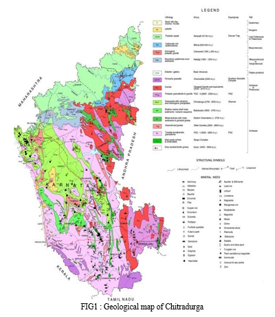
Chitradurga schist belt covers an area of 6000 sq kms with an average exposure of 60%. This Belt belongs to younger Greenstone belts named after the town Chitradurga in Karnataka state. Chitradurga town is about 225kms by road from bengalore city. Ingladhal village is about 10kms SE of Chitradurga Town.
Chitradurga town is located almost at the centre of the schist belt. It is considered as the possible archean suture, formed as a result of collision tectonics and closure of an oceanic basin, between two juvenile continental crustal blocks.region forms part of a major linear tract of supracrustal rocks extending 350 km south from Gadag~to Mysore in the bimodal gneiss supracrustal rock terrane of the Karnataka craton.
This tract is one of a series of irregular belts and basins containing sedimentary and basic and acid volcanic rocks (at low metamorphic grade) that form the Dharwar Supergroup. Dharwar metabasites near Chitradurga have given an Rb--Sr isotopic age of ca. 2350 Ma, but the Chitradurga Granite which intrudes these metabasites has yielded an Rb--Sr age of ca. 2500 Ma Pb isotopic data reveal ages of 2605 Ma for this granite and 2565 Ma for Dharwar acid volcanic rocks north of Honnali.
II. GEOGRAPHY OF THE AREA
FLORA AND FAUNA - Chitradurga is blessed with some of the most magnificent forests of the Indian sub-continent. The state is endowed with varieties of forest vegetation with an enormous diversity of species the floral diversity is so wide and varied that in some districts, all types of forest from wet evergreen to dry thorn forest are encountered within a crow-fly distance of less than 100 km exhibit high degree of plant diversity including varieties of medicinal plants. The total number of flowering plants (angiosperms) so far recorded in Karnataka is about 4,700 species belonging to 512 genera under 89 families. Out of these, over 60 species are exclusively endemic to chitradurga.There are also some faunas are Asian Common Toad Oriental Garden Lizard Rock Dragon Giant Leaf- toed Gecko Bengal Monitor Common Bronze back Tree Snake Rough- scaled Sand Boa etc.
CLIMATE - The climate here is considered to be a local steppe climate. During the year, there is little rainfall in Chitradurga. The temperature here averages 24.3 °C | 75.8 °F. The rainfall here is around 695 mm | 27.4 inch per year. Chitradurga are in the middle of our planet and the summers are not easy to define. The driest month is February, with 2 mm | 0.1 inch of rain. Most precipitation falls in October, with an average of 111 mm | 4.4 inch. April is the warmest month of the year. The temperature in April averages 28.3 °C | 83.0 °F. In December, the average temperature is 22.0 °C | 71.5 °F. It is the lowest average temperature of the whole year. In this location, the month that receives most sunshine is April, with a mean number of daily hours being 10.63. Across the entire duration of said calendar period there are an aggregate total of 329.62 hours' worth of sunlight. In January, the lowest number of daily hours of sunshine is measured in Chitradurga on average. In January there are an average of 6.21 hours of sunshine per day and a total of 192.57 hours of sunshine. In Chitradurga, an average of 102.64 hours of sunshine are counted per month and around 3118.22 hours throughout the year.
III. LITHOLOGY AND FIELD RELATIONS
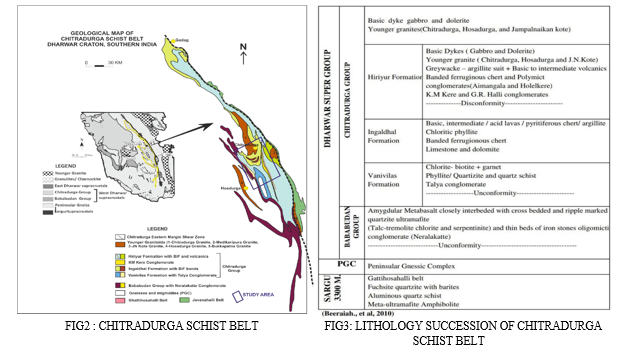
The rocks of this age show extreamely complex nature with clastic and chemically precipitated sediments, volcanic and plutonic rocks – all of which show varying degrees of metamorphism. The majority of the rocks are often phyllites, schists and slates. There are hornblende, chlorite, haematite, magnetite schists, feldspathic schists, quartzites and highly altered volcanic rocks, like rhyolites and andesites turned into hornblende- schists, abundant and widespread granitic intrusions crystalline limestones and marbles serpentinous marbles, steatite masses, beds of jespers and massive beds of iron and manganese oxides.
IV. SARGUR GROUP
Sargur group of rocks are best exposed at the talya section, they are existing as enclave in P.G.C. Sargur group of rocks belong to older greenstone belts of age > 3.300 m.a. these rock have undergone amphibolite facies of metamorphism i.e. they should not be called as true green stone belts. They are known as the ancient supracrustals. The assemblage occurs as large enclaves or lenses in the P.G.C. Sargur Group of rocks is exposed towards the western most limit of the chitradurga schist belt. It comprises of repeatedly alternate ultramafites and quartzites due to folding, the cores of the folds being occupied by quartzite. Bedded barites occurring in contact with fuchsite quartzite striking N-S, dipping E, Chlorite talc schist, micaceous quartzites, and amphibolites are the various lithologies occurring in the enclave. These rocks show complicated structures and are highly folded, faulted and have also undergone a high degree of alteration. Two major antiforms and synforms are encountered in the enclaves.

V. PENINSULAR GNEISSIC COMPLEX (P.G.C)
The P.G.C forms the basement for the Dharwar Supergroup. The granite- greenstone ratio of south central peninsular India is 4:1. The P.G.C formation dose not belong to particular period of episode (3600 m.a – 2000 m.a). The oldest P.G.C from Gorur-Hassan is dated as 3358+ or 66 m.a.
Chitardurga schist belt is bounded by P.G.C Two P.G.C quarries are studied in detail one near Challakere and the other at Talya section. These P.G.C rocks are migmatitic in composition. Originally doleritic rocks consisting of two or more petrographically diffrernt parte, one which is the country rock generally in a more or less metamorphic stage.
Several minor faults are noted a step faults, normal faults are reverse faults. The dragging of veins due to faulting indicating the direction of the movement of blocks. Some faults carry quartz veins and along some fault planes epidotisation is seen. Many generations of quartz veins are identifies by their cross cutting relationships, indicating that the origin of P.G.C does not belong to single period of epidote. Different stages of the sequence of assimilation as seen in the field as seen in the field are shown below.
Dolerite (linear)?Amphibolite (fafts)?diorite? granodirite? granite ? Leucogranite? Homogenised

VI. DHARWAR SUPERGROUP
The stratigraphy of the dharwar supergroup is best preserved in the chitradurga schist belt. An E-W traverse across the schist belt will help in constructing the stratigraphic sequence up to the younger Chitradurga granitic instrusion.
Dharwar supergroup consists of metavolcanic and metasedimentary rocks, divided into two groups
A. Bababudan Group
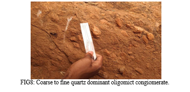
At the talya section to the east of P.G.C is overlain by the oligomictic conglomerate, which forme the base for the bababudan group. The oligomictict conglomerate indicates a vast period of rigorous erosion before the formation of bababudan group. Oligomict quartz pebble conglomerate is economically too important it is supposed to contain gold and uranium. The conglomerate bed is overlain by quartzite which is concordant with the oligomictic conglomerate . quartzite is overlain by amygdaloidal metabasalt. The amygdales are mainly secondary quartz, got elongated due to deformation. Therefore this group represents an alternate sedimentary and volcanic sequence of rocks. Bababudan group of rocks are not well developed in the chitradurga schist belt. The above described succession I seen in a few hundred meters of transverse length. This group is overlain by the polymictic conglomerate.
B. Chitradurga Group
Chitradurga group 2600-2900 belongs to the younger greenstone belts of the dharwar supergroup. It is divided into three formations
- Vanivilas Formation
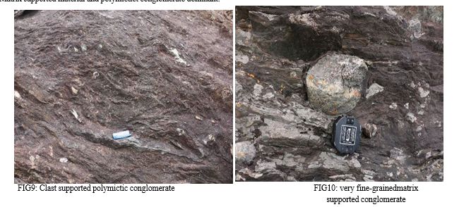
The polymictic conglomerate forms the base for the vanivilas formation is studied at the talya section. It has well rounded cobbles and pebbles of different lithologies, derived from the older formatins of the bababudan group. These pebbles and cobbles are hosted in amatrix of chlorite schist. The conglomerate is highly metamorphosed and deformed. Fine grained micaseous material within the quartz pebble can be seen here. It is green coloured with pearly lusture.
In this location indicates end of bababudan group and staring of vanivilas. Formation fine grained clay particles.
In this location we found conglomerates as matrix containing small pebbles of two different compositions. It is known as dimictite.
Long stretched polished pebbles indicates long transportation event. Occurrence of Talya Conglomerate.
Clast folded and granite clast also present which is derived from peninsular gensis.
Matrix supported material and polymictict conglomerate dominant.
2. Ingladhal Formation
BIF formation was noted here hermatite is more than magnetite so we called it as banded hematite quartzite with minor magnetite. The main feature we could observed was a multiple deformation event. Banded iron formation is present in this location with competency contrast. We also observed the evidences of speroidal weathering. BIF is the end of vanivillas formation and this specific location is the starting of ingladhal formation.
Here the rock type mainly consists of highly deformed coare to fine grained metabasalts, gabbro, some patchs of phyllite with pyroclastic tuff agglomerates. In some region variolitic bjasalts with pillow structure also observed.

3. Hariyur Formation
Hariyur formation which is younger to ingladhal formation is lying over polymictic conglomerate. This formation is marked by 80% sedimentary and 20% volcanic associations. Hiriyur formation starts with a polymictic conglomerate known as K.M.KERE conglomerate.
VII. K.M.KERE CONGLOMERATE
It extends from east of ingaldhal to south of elladkere for a length of about 40 km
Has a width varying from a few meters to as much as one km. It shows wides variations In the composition of matrix and pebbles along strike and dip.
An assortment of pebbles of various shapes and size, embedded in matrices of vastly
Different character constitutes the conglomerate. The pebbles include massive and schistose.
Lavas banded ferruginous chert, black chert, striped jasper, granite, quartz-sericite schist, Rhyolite, metagabbro, vein quartz, all of them indicative of derivation from the older Ingaldhal and vanivillass formation. Pyrite found in rock which indicate pyritiferous metavolcanic and it goes through a highly reducing condition called euxinic.
In argilites we observed fissility.

VIII. MINERALOGY OF THE CHITRADURGA DISTRICT
The two fuchsite mica samples described here are from the attractively green coloured portions of "the quartzite bed which encloses the recently discovered Precambrian bedded barytes deposits of the area The fuchsite quartzite forms the western or the lower portion of the bed (interestingly most of the barytes beds are also located in this portion), the bulk of which is buff white sericite-bearing quartzite. The fuchsite quartzite of the area is quarried at many places for ornamental stone and in several of these quarries the unmistakable interbedded sedimentary character of quartzite and baryte is exposed. The two samples used in this study are collected from the quarry on the southern slope of the low mound situated to the west of Gattihosahalli. Of the four samples collected for the present study, three represented the main fuchsite quartzite, which contains on an average 89 and 11 modal percents of quartz and fuchsite respectively. These are comparatively fine grained (the average fuchsite spangle in these is O·7m.mxO'Smm), lighter green coloured and only moderately foliated. The fourth sample, designated here as fuchsite-quartz schist, is relatively coarse grained (the average size of fuchsite spangles is l'2mm X O' OS mm), bright green coloured, strongly foliated and enriched (with an average of 23% modal fuehsite) in fuchsite. The fuchsite-quartz schist forms small segregation-like lenses and patches in the fuchsite quartzite. In thin section, the rocks show abundant (an average of 89 and 76 modal percent quartz in the fuchsite quartzite and fuchsite-quartz schist respectively), interlocking anhedral grains of quartz, distinctly bluish green coloured scales and anhedral plates of fuchsite and sporadically distributed small shapeless grains of rutile. Blades of kyanite (Zv, 85°) showing high relief occur in isolated lenses and patches only in the fuchsite-quartz schist specimen. Both quartz and fuchsite, although devoid of inclusions, always show undulose extinction, which it is strongly marked in the former.

IX. LITHOLOGY
Following is a description of major rock units in the study region. Much of the data is taken from the existing geological literature.
A. Oligomictic Conglomerate
It is a clastic sedimentary rock composed of a single rock type, such as an orthoclase quartzite conglomerate. The base of bababudan group has oligomictic conglomerate. Consisting of rounded quartz pebbles. Oligomictic rocks are characteristics of stable conditions such as are found in the epicontinenetal seas.
B. Barite
Thin bands and lenses of barite are associated with fuchsite quartzite and quartz arenite schist at one locality in the Ghattihosahalli belt. They are apparently syngetics or diagenitic.
C. Hyaloclastite
A deposit formed by the flowing or intrusion or lava or magma in water, ice , or water-saturated sediment, and its constant granulation or shattering into small angular fragments.
D. Cherts
Chert is the general term for sedimentary non-clastic material, and it may occur disapersed as nodules and sometimes as major part of whole geological formations hundreds and occasionally thousands of feet thick.
E. Greywacke
A dark firmly indurated coarse grained. Sandstone that consists of poorly sorted angular to subangular grains of quartz and feldspars.
Greywacke is abundant within the sedimentary section, in the older strata, usually occurring thick extensive massive or obscure stratification in the thicker units but marked by graded bedding in the thinner layers. Greywacke are typically interbedded with marine shales or slates, and association with submarine lava flows and bedded cherts.
F. Variolites
Variolites are volcanic rock tthat contain varioles within a fine matrix. Such rocks are commonly among archean mafic volcanic and have received attention to their origin. Varioles are spherical bodies that are lighter coloured than the host rock and range in diameter from 0.05mm to over 5cms. They occur in both tholeiitic and basaltic flows and in massive as well as pillowed units. Studies indicates that varioles and matrix represent quenched fractions of two immisible magmas were in contact prior to eruption. In most cases, one magma a corresponds to tholelitic.
G. Polymictictic Conglomerate
It is a clastic sedimentary rocks composed of many rock types polymictic conglomerate occurs at many levels and some were deposited directly on the basement.much of the conglomerate is unsorted with clasts supported by a matrix of chlorite-quartz-plagioclase greywacke composition or more rarely, arkose, small scale through crossbedding occurs in some conglomerates, but distinct bedding structures are absent elsewhere. The clasts can be metabasalts including metadolerites and metagabbro they include phyllite and chert but orthoquartzite predominates. Clasts of quartzite commonly are crossbedding. They have largely resisted postgranite and banded gneiss are least abundant except in parts of some conglomerate. Polymict conglomerate rocks are charteristics of mobile such as are found in the oregenic belts. Pichamuthu and natiyal draw attention of a fluvialglacial origin for the polymictic conglomerate but no evidence for the glacial origin has been identified.
H. Peninsular Gneiss
Peninsular gneiss refers to a large complex suite that consists much of the western dharwar craton. Most of the rocks are tonalite-trodhjomite gneiss, but a wide variety of screens and inclusions of other rock types is present. Some of these conformable bands are undoubtedly engulfed fragments of metavolcanic rocks fragments of older schists belts. The gneissic suit may include former sedimentary and volcanic rocks former intrusive rocks subjected to gneissic metamorphism and direct magmatic increments foliated during intrusion. These diverse components are conformably intermixed on such a small scale that they cannot be discriminated. Age of the paninsular gneiss is 3400 to 2900 m.a.
I. Quartzites
Quartzose rocks are common in enclave suites but rare in coherent high- grade schist belts.varietal minerals in the quartzites include kyanite, sillimanite, fuchsitic, kyanitic and sillimanitic varities and detrital primarily zircon, tourmaline rutile. The lack of internal structures suggests that they may represents aprone of resedimented sand deposited by turbidity flows emerging from submarine fans.
X. STRUCTURES
It can be devided into 2 broad catagories
A. Primary structure
1) Pillow Basalt
Pillow lavas (National Geological Monument) with cracks were observed. Age of the pillow lava is 2200Ma.Radial cracks were inferred to be due to the chilling of the margin first. These were also reasoned to be the youngest outcrops of the Ingaldhal formation.
Pillow lavas were formed as a result of outpour of molten rock. Staked pillows indicate under water eruption. Vesicles are found around pillow due rolling of lava. The topmost part of the exposure is full of vesicleswhere as if we go bottom we don’t find any vesicles.Vesicle shape depends upon how we cut the rock.
Pillow lava cools infrom outer margin to inner, hence the inner part is coarse grained andouter part is fine grained. We found chilled margin due to rapid cooling.

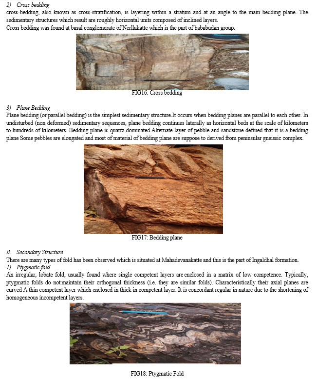
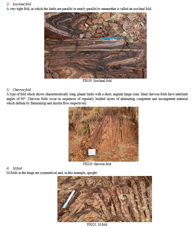

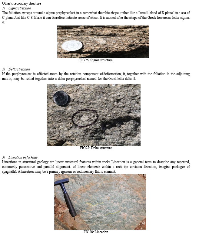


14) Volcanism
Volcanic rocks varying from spinifex textured peridotitic komatiites (STPK) to rhyolites are found in the Chitradurga schist belt scattered at several places from south to north. Though ultramafic schists (metavolcanics) occur mainly in the Ghattihosaballi part and southern part of the belt, STPK have been from the Kibbanballi arm of the belt. Jogimardi,Mardihal1i and BeHara volcanics have been studied in some detail but more complete and evolved suite of volcanic rocks are: found in the Gadag part of the belt where a complete sequence from basalt to rhyolite exists with well-preserved p1110w and spherulitic textures. Ultramafic schists are also found in the Gadag belt but their volcanic nature is not proved. The FeO-MgO ratio of the basaltic volcanics of the Chitradurga belt suggests that they have been derived by 10-15% melting of the mantle. Rkyolite could have been produced by the melting of the crustal rocks themselves. Detailed geochemiical studies on these volcanics, especially for REE and Sm/Nd isotopic determinations are awaited, for petrogenetic modelling. Pebbles of rbyolite are abundant in the conglomerate of the Gadag part of the belt. It is therefore inferred that the rhyolites in the belt are older than the Gadag graywackes. There is no evidence to suggest that volcanics of Kibbanahalli, BeHara, Mardihalli, Jogim~rdi and Gadag belong to one stratigraphic horizon. Even radiometric determinations may not be able to resolve the age difference between various flows, as the time gap of their emp1acement may be small, but field data clearly indicate that all these volcanics bave variable stratigraphic relationship with graywackes. Indirect relationship between volcanics and associated sediments indicate that volcanism has occurred at lea~t at two stratigraphic levels.
15) Sedimentation
Metavolcanics are interbedded with and are overlain by a variety of (1) chemogenic BIF (volcanogenic-volcanoclastic-exhalative sedimentary suite, (2) detrital mature quartzite-conglomerate-meta arkose- carbonaceous shale suite and (3) graywacke- phyllite-carbonate BIF suite. The chemogenic sediments include fuchsite quartzite, oxide- carbonate-sulpbide facies B1F, cherts, carbonates and Mn formatioos which are spread in all groups but with differing relative abundances. Vol canoclastic sediments include tuffs, volcanic breccia and probably ash beds. Detrital mature quartzites are found in the Bababudan and Javanahalli groups. Detrital mature conglomerates are found at the base of the Bababudan group. Graywackes and graywacke conglomerates are widespread in the Chitradurga group. More than 70% of the belt is made up of graywackes and graywacke conglomerates.
The chemogenic sediments of some part of the telt appear to have been derived from volcanogenic exhalative processes (Naqvi et ol ]981). The Ni and Cr contents of the sediments like barite, fuchsite quartzite and calc silicates are abnormal1y high ranging up to 1000 ppm Ni and 3000 ppm Cr The geochemistry of the volcanoclastic sediments has not been studied as yet. Graywackeconglomerates are found at different horizons and named as Talya, Aimangala,and Kurmardikere conglomerates in the' central part, Mayakonda in the northwestern part, and Kodkal-Bagewadi conglomerate in the Gadag part ihe conglomerates of the central part of the belt contain pebbles of quartzite, gneiss, tonalite, BIF, carbonate, amphibolite, vein. quartz, and chert. Pebbles of quartzite are often folded and represent an earlier-cycle of ductile deformation. During the Chitradurga orogeny, these pebbles witnessed brittle deformation In the conglomerates of Gadag schist belt, pebbles of rhyolites and porphyritic K-feldspar granite are found in addition. Presence of rhyolites and granite pebbles indicates that the Gadag conglomerates are younger than those of Chitradurga and have been deposited after intrusion of K-granites The graywackes of the Gadag part of the belt are also different from those of the central part. These graywackes contain abundant volcanic rock fragments and fragments of quartzites whereas the graywackes from the central part of the belt seldom contain volcanic rock fragments Also, marked differences are noticed in plagioclase K-feldspar and quartz/chert- quartzite ratios. Differences are found in the chemical composition also High MgO + Fe201 content of the G & dag graywackes reflects the high volcanic and BIF debris component as compared to that of the central part. Similarly, the Na20/K20 ratio e){hibits a very larg(: scatter in having relatively high K20 abundance. Rb, Sr, Ni, Cr, Co and Zr contents of th~ Gadag graywackes show a large scatter compared to those from the central part CNaqvi et at under preparation). The REE distribution patt~rns of the graywact
XI. MICROSTRUCTURAL DETAILS AND METAMORPHIC RELATIONS
Metavolcanic rocks of Bababudan Group in the CSB are mainly metamorphosed in the amphibolite grade. Preliminary analysis shows that these amphiboles are Ca–rich, indicating low–grade amphibolite facies condition. Amphiboles are grown in S1/S2 foliation planes indicating that the deformation has occurred during amphibolite facies conditions at least in metavolcanic rocks. Volcanoclastic sandstone has more quartz and plagioclase in the matrix with two types of amphiboles. One generation of amphibole grains are aligned parallel to the foliation (type A), and other generation of amphiboles (type B) are randomly aligned.
This implies two–generation amphibole growth in the Bababudan Group, and the exact reason behind this is not clear yet. In chlorite–actinolite schist, chlorite is seen as the crenulated porphyroclast within a quartz–rich matrix, and actinolite is developed along S4 shear planes . S–C–C’ relation shows a dextral sense of movement.
Pyrite is also present as an accessory phase in this sample.
Quartzites in the Bababudan Group are having muscovite in their S2/S3 foliation plane; in some localities presence of fuchsite is also noted.
For samples from Chikkaramapura (13 km NE of Kibbanahalli) within a narrow shear zone in the Bababudan–Chitradurga Group boundary, biotite is seen along ‘S’ foliation, and muscovite is developed along ‘C’ planes, and S–C fabric shows a sinistral sense of motion. Similarly, within folded samples also muscovite is developed along the grain boundaries of biotite, indicating the same retrograde metamorphic condition for both D2 folding and D3 shearing.
In some samples two generations of biotite are present, the first generation in the matrix is probably detrital in origin. The second generation of biotite is developed along the shear planes along with muscovite.
Hiriyur Group rocks have chlorite and muscovite developed along the shear planes. Typical sandstone from Hiriyur Group has quartz, plagioclase, calcite and muscovite as the main assemblage, with chlorite and muscovite aligned along the S3 foliation plane. Shear related, S3 foliation shows a sinistral sense of motion S–C–C’ fabric defined by muscovite and asymmetrical tails around quartzite clast in the conglomerate sample of the Chitradurga–Hiriyur boundary shows east–side–up motion sense, indicating a reverse sense of movement.
Sheared rocks from the Akkanahalli Zone of GMSZ also have chlorite in the shear plane, and some samples have muscovite developed along the S3 shear plane. S–C–C’ shear planes are prominent, suggesting a sinistral sense of movement.
It is evident from the above–mentioned fact that, from the lower to upper layer of the stratigraphic column, the metamorphic grade has a transition between Bababudan, Chitradurga, and Hiriyur Groups along with the Akkanahalli Zone. Metavolcanic rocks in the Bababudan Group are metamorphosed in amphibolite facies condition. Metasedimentary rocks in both, Bababudan and Chitradurga Groups are metamorphosed in biotite–muscovite grade, but the Hiriyur Group, Akkanahalli Zone, and GMSZ region are metamorphosed in muscovite–chlorite grade, consistent with the observations in Hokada et al.
XII. MAPPING
Map is a symbolic representation of selected characteristics of a place usually drawn on a flat surface. Maps present information about the world in a sample, visual way. They teach about the world by showing sizes and shapes of countries, locations of features, and distance between places. We learned about two type of mapping in the field
A. Plane Table Mapping
Plane table surveying is the graphical method of surveying in which field observation and plotting are done simultaneously helping the surveyor to compare the plotted details with actual features of the ground.
Process of plane table mapping –
Plane table mapping involves the preparation of a map in the field by direct observation. Details can lso be added to existing maps or aerial photographs by this process. In the classical method a single operator uses simple equipment that can be hand-made whereas stadia mapping involves a minimum team two and more expensive equipment.
The basis of either method is to secure a sheet of paper or other material to a table and so locate points with rays drawn.
The operation involves two steps-
- Construct an accurate triangulation network
- Fill in detail as required this may be topographical geological botanical geomorphological etc. Both stages may be carried out simultaneously.


Mapping is increasingly become multi disciplinary. lithological mapping activity is usually combined with geochemical grid pattern sampling for preparing geochemical maps. For rapid coverage of large areas, high mountainous ranges and inaccessible terrains, remote sensing and aerial photographs are used extensively.
2) Steps Involved In Geological Mapping
Once an area is selected for geological mapping it is essential to collect the available geological and geographical data of the chosen area.
The latest topographic maps published by Survey of India on 1:50000 and/or 1:25000 scales as required are to be obtained to use as a base map. It is important to carry out the survey by traverses to determine the various lithologies present and their order of superposition.
While mapping, useful information can be obtained by studying well section, road cutting, tunnels, mine working etc.
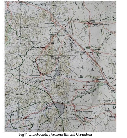
The exact location of ones position must be determined by intersection of bearing lines and contour lines. A geologist should become proficient in estimating the distance. He should also check the features on the toposheet. Geological mapping should be carried out systematically with object of covering the entire area. After studying the outcrop, the rock type should be noted and located on the map. Geological boundaries should be drawn in full lines whereas an approximate boundary should be indicated by broken lines. Joints, Fractures, Folds, Plunge of lineation, Dip, Strike and Foliation of lithological beds should be noted on the map. Every geological map should have a legend explaining the characteristic lithological units.The scale and direction of geographic north line should be clearly indicated. The geological maps prepared by following these steps are of standard type, and will give most of the required information and this information can be easily understood by the observers.
In the present field work, Brunton compass was used to measure the strike and dip of formations and lithological contacts have been marked based on readings obtained using a GPS.
XIII. ACKNOWLEDGMENTS
I am Very Thankful to My University Professors for Their Kind and Constant Support and Help.
Conclusion
Detailed field and structural studies in the southern part of CSB were carried out. Unconformable relations between basement rocks, Bababudan Group, Chitradurga Group, and Hiriyur Group are identified. Geological and structural relationships between different rock types show these unconformities developed in a sedimentary setting within a shallow marine environment. A progressive change in the metamorphic grade from the Bababudan Group to the Hiriyur Group is observed. Volcanic and sedimentary rocks of the study area show characteristics evolved in a narrow basin of failed rift zone developed by the fracturing of basement rocks, rather than an accretionary prism evolving during the subduction process. Inversion tectonics related collision events should have resulted in sinistral transpression that post–date rifting events. The stratigraphy of the Chitradurga region suggests depositional events began after peneplanation and mature weathering of the Peninsular Gneiss basement. Basal quartz-pebble conglomerate and cross-bedded quartzites probably formed in relatively shallow water in a platformal environment Basic volcanism and sporadic introduction of crossbedded, clean washed sands, locally with spectacular penecontemporaneous dewatering structures in south-east Bababudan, characterize this platformal regime which we suggest covered much of the Karnataka craton at this time.Formation of the dewatering structures may have been triggered by seismic shocks related to volcanism and faulting of the basement. Thicker basic volcanic rocks within the Chitradurga arc indicate greater subsidence of the sialic foundation which we relate to rifting and graben formation. Greater rates of subsidence in this part were maintained throughout the stratigraphic evolution of the belt, though progressive deepening of the whole basin also took place to accommodate the youngest rocks, namely, greywacke—turbidites and local polymict conglomerates represented in the Chitradurga region by the Aimangala Conglomerate. The fine grain size, thin bedding and grading in uplift of the basement and injection of diapirs. However, recumbent folds may not be common in the Dharwar supracrustal belts and younger granitoid material appears to be less widespread at the present level of exposure in the basement foundation to these belts in Karnataka.
References
[1] Belousova, E.A., Kostitsyn, Y.A., Griffin, W.L., Begg, G.C., et al. (2010) The growth of the continental crust: constraints from zircon Hf–isotope data. Lithos, 119, 457–466. [2] Chadwick, B., Ramakrishnan, M. and Viswanatha, M.N. (1981) The stratigraphy and structure of the Chitradurga region: An illustration of cover–basement interaction in the Late Archaean evolution of the Karnataka Craton, Southern India. Precambrian Research, 16, 31–54. [3] Chadwick, B., Vasudev, V.N., Hegde, G.V. and Nutman, A.P. (2007) Structure and SHRIMP U/Pb zircon ages of granites adjacent to the Chitradurga Schist Belt: Implications for Neoarchaean convergence in the Dharwar Craton, Southern India. Journal of Geological Society of India, 69, 5–24. [4] Gokarn, S.G., Gupta, G. and Rao, C.K. (2004) Geoelectric structure of the Dharwar Craton from magnetotelluric studies: Archean suture identified along the Chitradurga–Gadag schist belt. Geophysical Journal International, 158, 712–758. [5] Sengupta, S. and Roy, A. (2012) Tectonic amalgamation of crustal blocks along Gadag–Mandya Shear Zone in Dharwar Craton of southern India. Journal of the Geological Society of India, 80, 75–88. [6] Radhakrishna, B.P. (1983) Archean granite–greenstone terrane of the South Indian Shield. Geological Society of India, Memoir, 4, 46. [7] Mukhopadhyay, D., Baral, M.C. and Ghosh, D. (1981) A tectono– stratigraphic model of the Chitradurga Schist Belt, Karnataka, India. Journal of Geological Society of India, 22, 22–31. [8] Dhuime, B., Hawkesworth, C.J., Delavault, H. and Cawood, P.A. (2017) Continental growth seen through the sedimentary record. Sedimentary Geology, 357, 16–32. [9] Mishima, K., Yamazaki, R., Satish–Kumar, M., Ueno, Y., et al. (2017) Multiple sulfur isotope geochemistry of Dharwar Supergroup, Southern India: Late Archean record of changing atmospheric chemistry. Earth and Planetary Science Letters, 464, 69–83.
Copyright
Copyright © 2023 Pekham Ganguly. This is an open access article distributed under the Creative Commons Attribution License, which permits unrestricted use, distribution, and reproduction in any medium, provided the original work is properly cited.

Download Paper
Paper Id : IJRASET56342
Publish Date : 2023-10-28
ISSN : 2321-9653
Publisher Name : IJRASET
DOI Link : Click Here
 Submit Paper Online

