Ijraset Journal For Research in Applied Science and Engineering Technology
- Home / Ijraset
- On This Page
- Abstract
- Introduction
- Conclusion
- References
- Copyright
Traffic Volume Studies and Congestion Solutions of Urban Road in Junagadh City
Authors: Shailendra Parmar, Bonny Bhut, Shekhar Parmar
DOI Link: https://doi.org/10.22214/ijraset.2024.62223
Certificate: View Certificate
Abstract
Urbanization is a defining feature of modern civilization, with cities rapidly evolving into hubs of economic, social, and cultural activities. As the developing cities continue to grow in population, the efficient movement of people and goods becomes a critical challenge due to the increasing amount of vehicle. One of the central aspects influencing urban mobility is the traffic volume on road sections. As the population continues to grow, the volume density of traffic on roads also increases. This analytical paper aims to explore the problems faced by various road users, including vehicle users, pedestrians, and other users, due to the rise in traffic volume density. The study highlights the challenges associated with increased traffic, such as congestion, longer travel times, safety concerns, and environmental impacts. By understanding these issues, policymakers and transportation authorities can develop effective strategies to mitigate the negative consequences of increased traffic volume density. In this project, traffic on the urban road between two intersections at both ends of MG Road in Junagadh city is studied. Owing to the continuous growth of population, growth in number of vehicles and concentrated development of the city resulted into traffic congestion which calls for the demand of remedial measures especially in between the intersections which is not managed and control appropriately and thus resulting in decreased facilities to moving vehicles and pedestrian. Due to the lack of land, adding more lanes or constructing a grade separator to improving the traffic flow or increase capacity is not an easy task. However, efficient use of existing resources for the remedial measures which doesn’t cost much could be a proper solution to overcome congestion issue
Introduction
I. INTRODUCTION
The essence of the importance of transportation is encapsulated in the statement that mobility is guiding civilization toward a more optimistic future. Presently, transportation stands out as one of the most pressing issues on a global scale. Each country addresses transportation challenges uniquely, tailoring solutions to its specific needs and capacities. When developing architectural plans, it is crucial to determine the loads exerted on the structure to calculate the necessary reinforcement for ensuring the secure functioning of the building. In transportation, volume plays a crucial role. Whether you're planning, designing, or operating a transportation system, knowing the volume is essential. Volume refers to the number of vehicles passing a particular part of a road. However, expressing this as a simple count per unit time becomes problematic when dealing with diverse vehicle types with different characteristics. To address this, traffic volume is often measured in terms of Passenger Car Units (PCU) per hour, where different vehicles are converted into equivalent passenger cars.
Handling traffic with various vehicle types interacting on the road can be quite complicated. Moreover, traffic volume is not constant; it changes over time. To keep the transportation system running smoothly, it's crucial to continuously calculate and monitor the volume. If this data is not consistently available, the transportation system could face challenges, potentially causing difficulties for the country's economy.
II. PROBLEM STATEMENT
The population of Junagadh city is 4.39 lakh as per the 2023 updated data. The population has grown from 3.19 lakh in 2011 to 4.39 lakh by the year 2023. Due to urbanization, vehicular ownership is growing very rapidly in Junagadh city. In Junagadh city scenario of vehicular growth is presented in table below.
Also due to poor public transportation system more use of private vehicles by people. There are various factors which creates congestion on the road like, mixed vehicle types, road condition, insufficient road capacity, weather condition, inefficient traffic management, inadequate public transportation, Lack of Alternative Modes of Transportation etc.
The problem of traffic congestion is one of the most significant in modern city. So, it is necessary to take steps to reduce the problem of congestion and to provide effective solutions.
A. Scope of study
The aspects of vehicular flows include their volume, types, and the distribution of traffic over time and directions. The volume of traffic, or magnitude, is determined by how many vehicles are present. Vehicles are categorized based on their size and capacity. On a two-way road, we count the vehicles moving in each direction separately to understand the proportion. Analysing the time and directional split helps identify patterns like tidal flow.The distribution of vehicles in the traffic flow. The proportion of vehicles reveals whether public or private transportation is more prevalent in the traffic system. It also reflects the preferences of road usersChanges in the flow of traffic on various approaches at a junction or different segments of a road network system.Variations in vehicular flows across hourly, daily, yearly, and seasonal intervals. Understanding these fluctuations is essential for determining expansion factors for future planning. By utilizing these expansion factors, the Annual Average Daily Traffic (AADT) can be calculated based on a short count.
B. Objective of study
To conduct a thorough study of traffic volume patterns on a selected urban road section..Quantifying the traffic volume on the chosen road section..Analyzing congestion patterns and identifying bottlenecks.To identify the key factors contributing to congestion in the chosen road section..Proposing contextually relevant congestion mitigation strategies.To propose effective and practical solutions for mitigating congestion and improving traffic flow.
III. STUDY AREA DETAILS
Junagadh District is one of the 33 districts in the State of Gujarat, India. Positioned in the western part of Gujarat within the region known as Saurashtra, Junagadh was historically one of several princely states in the Saurashtra region before India gained independence in 1947.The total area of Junagadh city spans 160 square kilometres, spanning from : 21°31′19.9″N to 70°27′28.4″E with a population density of 2000 individuals per square kilometer.As of the 2011 census, Junagadh municipality had a population of 319,462. Over the span of a decade from 2001 to 2011, the population of Junagadh district experienced a growth of 9.87 percent.
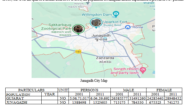
The population of Junagadh city is 3.19 lakh as per the 2011 census data. The population has grown from 2.23 lakh in 2001 to 4.39 lakh by the year 2023.
IV. DATA COLLECTION
The purpose of this survey is to comprehend the traffic dynamics, including average daily traffic, traffic composition, peak hour traffic, and directional split at specific survey locations. This survey is undertaken for various types of highway projects to gain insights into the diversity of vehicles passing through.
There is variety of vehicles are in the existence in urban areas of India. There is major two types of transport vehicles visible on Indian roads which are
- Motorized Vehicles
These are the vehicles which runs with any mechanical arrangement inside the vehicle. There may be patrol, diesel or any other type of electric engines which provides the power to the vehicle to move from one place to another one.
Motorized transport includes vehicles like:
- 2 wheelers scooters and mopeds
- 3 wheelers rickshaws and other 3ws
- 4 wheelers cars
- Light commercial vehicles
- High commercial vehicles
- Buses
2. Non-Motorized Vehicles
These types of vehicles are normally hand drawn type of vehicles or pulled or pushed by any animals like camels, bullocks, etc. or driven by user but not containing external power for movement like bicycles.
A. Data Collection Method
Before going for the actual work, we have conducted a reconnaissance survey on the previous day of actual work. We decided to do Direct survey of Manual Counting Method with the help of ‘Traffic Volume Count Mobile Application’. We visited the section of study and divided two groups at both ends of the road and four groups at selected junctions in between both ends of the road. We have conducted the survey of peak hours for the four days (24-Feb-2024 to 27-Feb-2024) including Saturday, Sunday, Monday and Tuesday of the week for better understanding of the volume of vehicles.
Then we took the average of the collected 4 days data in 15 min spans to find out the actual vehicle compositions of different vehicle types to define equivalent PCU factors.
B. Passenger Car Unit
A Passenger Car Unit (PCU) is a standard measure used in transportation engineering to represent the traffic flow and capacity of a road network. It serves as a way to express the varying effects of different types of vehicles on traffic congestion. The PCU is typically defined as an equivalent unit of passenger car size and traffic flow characteristics.
In simpler terms, it allows for the standardization of diverse vehicles based on their impact on traffic. For instance, a larger or slower-moving vehicle may be assigned a higher PCU value than a smaller or faster-moving passenger car. This unit simplifies the analysis and planning of road systems by treating all vehicles in terms of their equivalent impact on traffic flow, helping in the evaluation of road capacities and congestion levels.
VI. ACKNOWLEDGMENT
I would like to express my sincere gratitude and appreciation to all those who contributed to the successful completion of my project thesis report, titled " Traffic Volume Studies And Congestion Solutions Of Urban Road In Junagadh City." I extend my heartfelt thanks to my dedicated project guide, Mr. Bonny M. Bhut (Assistant professor), for their invaluable guidance, unwavering support, and insightful feedback throughout the course of this project. Their expertise has been instrumental in shaping and refining my work.
I am also thankful to Mr. Shekhar H. Parmar (Assistant Professor) for their constructive critiques and valuable suggestions that have enriched the quality of this thesis. Special thanks to my peers and colleagues for their collaborative spirit and for sharing their knowledge and experiences, which significantly contributed to the overall development of this project. I would like to acknowledge the support of my family and friends, whose encouragement and understanding have been a constant source of motivation.
Conclusion
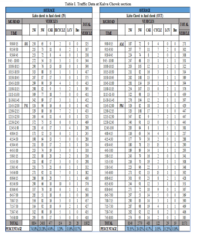
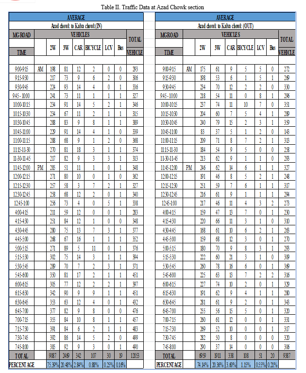
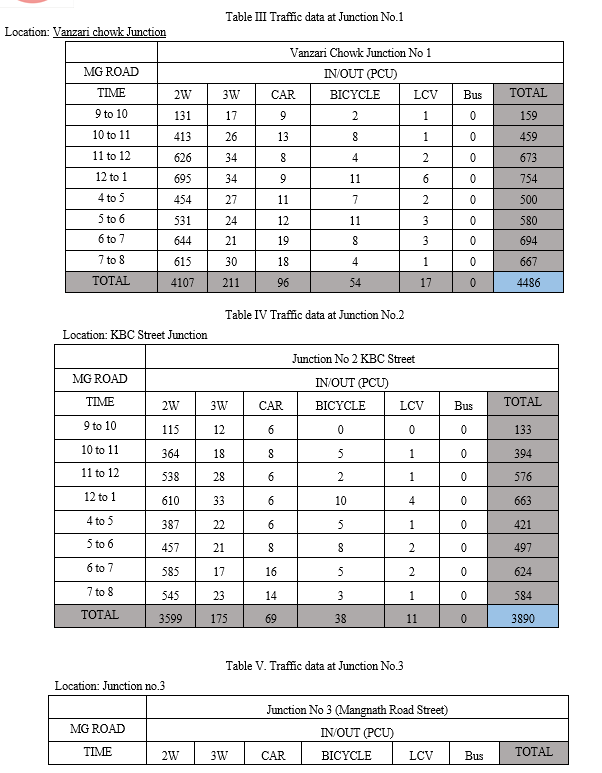
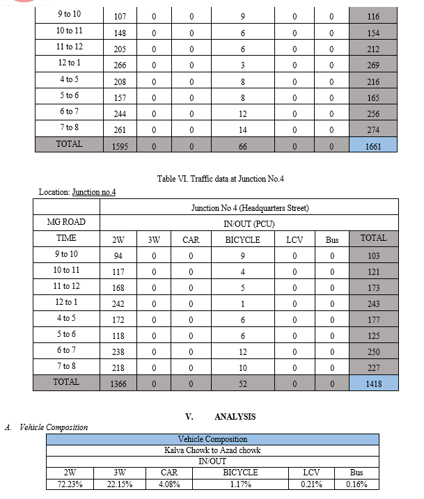
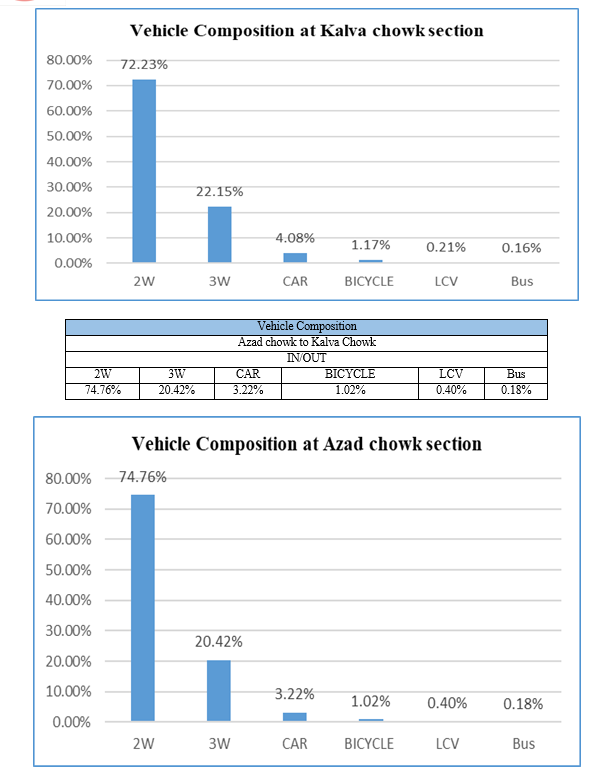
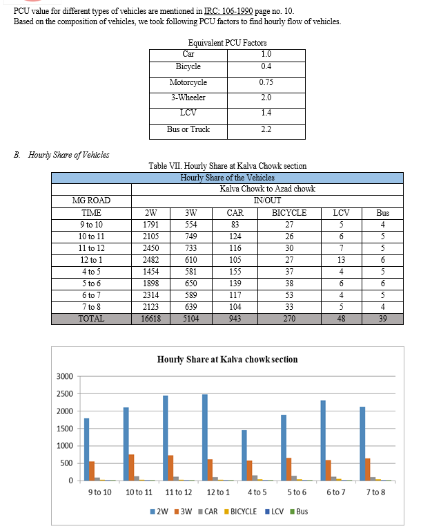
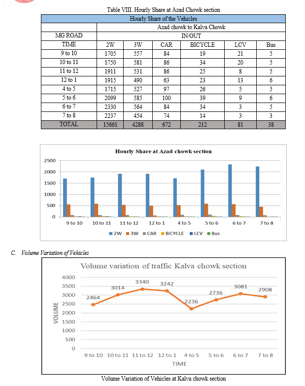
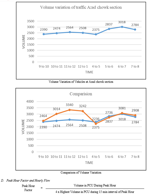
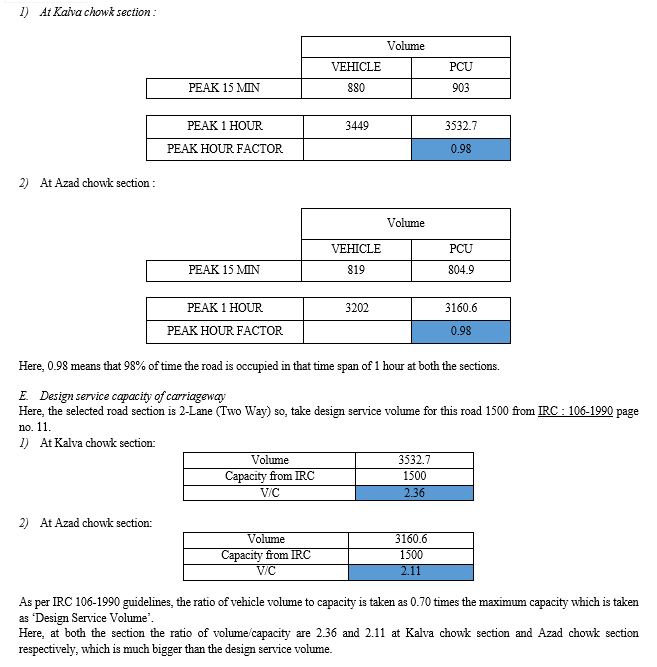
A. Conclusions 1) Discussion on vehicle composition: From the data, we can see that most vehicles in the area are motorcycles and three-wheelers, with cars making up a smaller portion. This distribution indicates a heavy reliance on two-wheelers and three-wheelers for commuting between Kalva Chowk and Azad Chowk. Buses, though fewer in number, are usually municipal buses or police vehicle. This suggests a need for better public transportation, including more buses and improved maintenance. Overall, the data highlights the importance of upgrading the transportation system to better serve the community\'s needs. In conclusion, while the dominance of light vehicles reflects the proximity of the location to high-income residential areas, also there is no presence of public transportation buses underscores modification in the transportation system. Therefore, strategic interventions aimed at bolstering public transportation services and modernizing existing fleets are warranted to enhance the efficiency and quality of the traffic system. 2) Discussion on survey data of Four junction: a) Junction No 1 (Vanzari Chowk Junction): • This junction shows varying levels of traffic throughout the day, with peaks during the 11 AM to 12 PM and 6 to 7 PM time slots. • The total number of vehicles recorded is 4,486. b) Junction No 2 (KBC Junction): • Similar to Junction No 1, this junction experiences peaks during the 11 AM to 12 PM and 6 to 7 PM time slots. • The total number of vehicles recorded is 3,890. c) Junction No 3 (Mangnath Road Street): • This junction exhibits lower traffic volumes compared to Junctions No 1 and 2, with peaks during the 6 to 7 PM time slot. • The total number of vehicles recorded is 1,661. d) Junction No 4 (Headquarters Street): • Junction No 4 also shows lower traffic volumes, with peaks during the 6 to 7 PM time slot. • The total number of vehicles recorded is 1,418. Based on the comparison, Junction No 1 (Vanzari Chowk Junction) has the highest total number of vehicles recorded, indicating potentially higher levels of traffic and congestion. Junction No 2 (KBC Junction) follows closely behind in terms of total vehicle count. Therefore, Junction No 1 is more likely to create more trouble for the main road due to the higher volume of traffic it experiences. 3) Discussion on hourly share of vehicles: Based on the survey, we can observe that the data is collected between 9 AM to 8 PM, the highest numbers of vehicles observed are during the 6 to 7 PM time slot, followed closely by the 7 to 8 PM time slot. Two-wheelers dominate the traffic throughout the day, with their numbers peaking during the evening rush hours. The data highlights the importance of understanding the hourly distribution of vehicles to effectively manage traffic flow and plan transportation infrastructure. It suggests that measures may be needed to address peak traffic periods, particularly during the evening rush hours, to ensure smoother and more efficient travel between the two locations. Overall, the data underscores the need for strategic planning and management of transportation resources to alleviate congestion and improve commuting experiences for residents and commuters in the area. 4) Discussion on volume variation of traffic a) Kalva chowk section: • This direction experiences varying levels of traffic throughout the day, with peaks during the 11 AM to 12 PM and 6 to 7 PM time slots. • The total number of vehicles recorded in this direction is 23,021. b) Azad chowk section: • This direction also shows fluctuations in traffic volume, with peaks during the 11 AM to 12 PM and 6 to 7 PM time slots. • The total number of vehicles recorded in this direction is 20,951. Comparing the total volume of traffic between the two directions, Kalva Chowk section has a higher total number of vehicles recorded (23,021) compared to Azad Chowk section (20,951). Therefore, Kalva Chowk to Azad Chowk direction potentially experiences higher levels of traffic and congestion, indicating it may create more trouble for the main road compared to the Azad Chowk section. 5) Discussion on hourly flow of vehicles: a) Kalva chowk section: • This direction experiences varying levels of traffic throughout the day, with peaks during the morning and evening rush hours. • The total hourly flow of vehicles varies between 595.9 PCU and 903.0 PCU. • The peak hour for this section is 11:15 AM to 12:15 PM. • The total volume of vehicles recorded in this direction is 24,393. b) Azad chowk section: • TShis direction also shows fluctuations in traffic volume, with peaks during the morning and evening rush hours. • The total hourly flow of vehicles varies between 520.9 PCU and 870.1 PCU. • The peak hour for this section is 7:00 PM to 8:00 PM. • The total volume of vehicles recorded in this direction is 21,758.8. 6) Discussion on design service capacity of road section: Both sections are experiencing traffic volumes exceeding their capacity as per IRC standards. As per IRC 106-1990 guidelines, the ratio of vehicle volume to capacity is taken as 0.70 times the maximum capacity. It indicates the degree of congestion, with higher values suggesting more severe congestion. The V/C ratio of both section is much higher at Kalva Chowk (2.36) and Azad Chowk (2.11), indicating potentially higher levels of congestion at throughout the section. B. Recommendations 1) Periodic Review of Design Standards: It\'s crucial for transportation authorities to regularly reassess and update design standards to match evolving traffic dynamics, urban population growth, and development patterns. 2) Parking Facility: We observed that there is a need for better parking facility alongside the road due to the lack of parking space besides carriageway. 3) Expansion of Carriageway: Considering the evident correlation between carriageway capacity and road width, exploring options to widen carriageways where possible is prudent. This could involve repurposing space from non-essential areas, lane reallocation, or innovative solutions like road widening projects. 4) Integration of Sustainable Transportation: Alongside expanding road capacity, emphasis should be on promoting sustainable transportation modes such as public transit, cycling infrastructure, and pedestrian-friendly designs. This holistic approach not only eases congestion but also addresses environmental concerns and enhances urban quality of life. 5) Technology Integration: Leveraging advancements in traffic management technologies, like intelligent transportation systems (ITS), can optimize traffic flow, enhance safety, and maximize the utilization of existing road infrastructure. Real-time traffic monitoring, signal synchronization and adaptive control systems can significantly enhance urban road network efficiency. 6) Community Engagement: Engaging local communities and stakeholders in the planning process is vital for garnering support for road design initiatives. Collaboration with residents, businesses, and advocacy groups ensures that urban road designs align with community needs and aspirations. Implementing these recommendations can help urban areas develop resilient road networks that cater to current and future transportation demands while promoting sustainability, safety, and accessibility for all road users.
References
[1] , “A survey of road Traffic Congestion Measures Towards a sustainable and Resilient Transportation System” Tanzina Afrin, Nita yodo, Department of Industrial Manufacturing Engineering, North Dakota,2020 [2] “Traffic volume studies & congestion solution” Vishal Singh, Shaib Shabir, International Journal of Scientific Research in Engineering and Management (IJSREM) July – 2021 [3] “Analyzing traffic patterns on street segments based on GPS data Using R software” Emililian Necula, , Publication: Science direct (2015) [4] “Traffic congestion in Buenos Aires: diagnosis and public policy Recommendations for a more Sustainable city” Juan Ignacio Fulponi, AIIT 3rd International Conference on Transport Infrastructure a Nd Systems (TIS ROMA 2022), 15th-16th September 2022, Rome, Italy (science direct) [5] “Smart Traffic Scheduling for Crowded Cities Road Networks” Md. Abdul Fattah, Syed Riad Morshed, Syed Yad Morshed, Md. Mojammel Hoque, Md. Nazmul Haquea Egyptian Informatics Journal 23 (2022) [6] “Optimized solutions for resolving traffic congestion at university circle” Akshay Jadhav, Deepak Anchule and Shekhar Bade International Journal of Civil Engineering and Technology (IJCIET) Volume 7, Issue 2, March-April 2016, pp. 278–289, Article ID: IJCIET_07_02_024 [7] “Optimized solutions for resolving traffic congestion at university circle”, Chandan Kumar Dey, Siba Prasad Mishra, Kamal Kumar Barik and Deepak Ku. Sahu, Current Journal of Applied Science and Technology 41(7): 45-60, 2022; Article no. CJAST.85664 ISSN: 2457-1024 [8] “Suggested Solutions for Traffic Congestion in Greater Cairo” Abdul-Wahab El-Kadi1, Journal of Sustainable Development; Vol. 6, No. 11; 2013 ISSN 1913-9063 E-ISSN 1913-9071 [9] , “A Survey of Methods and Technologies for Congestion Estimation Based on Multisource Data Fusion” Dominik Cvetek, Mario Muštra, Niko Jeluši? and Leo Tišljari? Journal: Appl. Sci., 2021 Volume: 11 Number: 2306 [10] “Geographical patterns of traffic congestion in growing megacities: Big data analytics from Beijing” Pengjun Zhao, Haoyu Hu, Volume 92, September 2019, Pages 164-174 (Elsevier). [11] “Congestion, Road Safety, and the Effectiveness of Public Policies in Urban Areas” Daniel Albalate and Xavier Fageda , Sustainability 2019, 11(18), 5092 [12] “Assessment of traffic congestion scenario at the CBD areas in a developing city: In the context of Khulna City, Bangladesh” Md. Asaduzzaman Noor, Sultana Ashrafi, Md. Abdul Fattah, Syed Riad Morshed, Saima Rahman, Transportation Research Interdisciplinary Perspectives 11(2021) 100435. [13] https://cot.gujarat.gov.in/statistics-junagadh-en.htm [14] https://cot.gujarat.gov.in/rto-junagadh.htm
Copyright
Copyright © 2024 Shailendra Parmar, Bonny Bhut, Shekhar Parmar. This is an open access article distributed under the Creative Commons Attribution License, which permits unrestricted use, distribution, and reproduction in any medium, provided the original work is properly cited.

Download Paper
Paper Id : IJRASET62223
Publish Date : 2024-05-16
ISSN : 2321-9653
Publisher Name : IJRASET
DOI Link : Click Here
 Submit Paper Online

